DC region forecast: Powerful weekend storm expected to bring heavy rain, gusty wind
Rain, wind expected to pound East Coast this weekend
A powerful storm could bring rain and wind to the D.C. region this weekend. FOX 5's Mike Thomas has your weekend forecast.
BETHESDA, Md. (FOX 5 DC) - Something that we watch for very carefully in El Niño winters is the storm track.
As we mentioned in our FOX 5 Winter Weather Outlook, winters like this one tend to feature some big storms.
Most of them, however, tend not to be snowstorms or blizzards, but instead heavy rainmakers.
That is exactly what we are in for this coming weekend, as a powerful storm system pushes north up the East Coast.

Much like last weekend, Saturday is expected to be the pick of the weekend.
Some morning sunshine, temperatures in the middle 50s.
By the middle of December by standards, it is a really nice day!
Clouds will be on the rise, however, as the storm develops to our south. By Sunday, clouds will greet us by the morning hours, though it does look like it should stay mostly dry through lunchtime.
By the late afternoon and evening hours, however, rain will start pushing into our region from south to north.

Rain could be rather intense during the evening hours, much like it was last Sunday evening.
Travelers in our region should exercise caution, especially after the sunset hours.
We should also be on guard for the potential for some localized flooding concerns given the wet pattern we have been in this month.
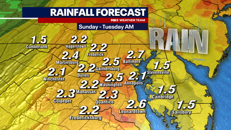
Early model projections are that between one and three inches of rain will be possible with this storm system, which could linger into Monday morning. If that all sounds familiar, that’s because this is nearly identical to the forecast from last weekend here in the D.C. region.
Dynamically though, that was a different setup that led to the same results. It was essentially a strong cold front that pulled in a lot of Gulf moisture. The system this weekend is an actual area of low pressure that will end up being the equivalent of a strong Nor’easter without snow.

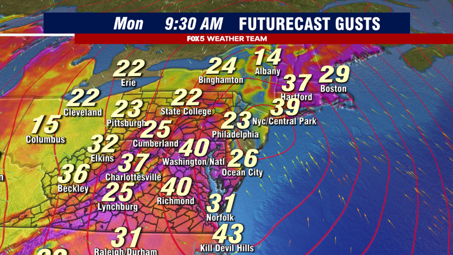
Even without the snow component though, we still have to watch out for another very common threat from Nor’easters, and that is strong winds. Particularly overnight into the early morning hours of Sunday, winds could at times gust 30-40 mph or greater.
This time of year, after the ground got soaked last weekend and trees are weaker as they go into dormancy for the winter, we will have to monitor for the threat of downed branches, trees, and power lines.
The Monday morning commute could be a rough one as the storm system exits the region. Winds are expected to remain gusty through the day on Monday.

Speaking of snow, many around the region remember that last weekend’s system ended with a period of steady snow. Enough for several inches to fall in some locations, to the point that several school districts decided to delay schools early Monday morning.
With this particular storm, that is less likely to happen with the Monday portion of the storm, as cold air is hung up well to the west with this storm system.
The storm track itself would be one that will be a big-time snowmaker for much of the Mid-Atlantic and Northeast, but the lack of any connection to a cold air mass will prevent that this time around.

However, as that storm exits to the north on Monday, colder air will be pushed southward into our region on Monday night. Overnight into Tuesday, a strengthening upper-level trough will dip into the region.
There is a lot still up in the air about exactly how the upper-level energy associated with this trough will track, and exactly how much moisture it will have available to it, but there is the threat that parts of our region could see a little snow falling around here during the early hours of Tuesday.
- Winter 2023 - 2024: What you need to know
- The science behind how El Niño's return will affect winter weather in DC
- FOX 5 Forecast: Winter 2023-2024 in the DMV
Typically, there ends up being more snow showers and flurries than anything else. There are some scenarios though where a more intense trough could lead to some areas of heavier snow showers or even snow squalls, so these will be threats we will monitor into the new week.
At this time, no model shows significant snowfall in our area yet, though. We will continue to monitor this threat through the weekend.

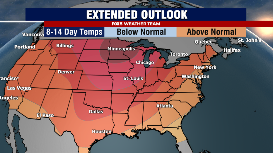
In the short term, expect another wet end to your weekend. Saturday is absolutely the best day to get outdoor activities and traveling done. Beyond the storm, the pattern for much of the United States looks warmer than normal in the run-up to the Christmas holiday.
With a ridge centered over the north-central portion of the country into Canada though, the potential for storms to "slip under the ridge" and pull into the East will be one we need to watch for into the end of the month.
We are expecting another strong storm between Christmas and New Year, though it’s far too early to say if it is looking like another rain event like this weekend, or if it has more wintry potential.
DMV Winter 2023-2024 Outlook
Here's why we're expecting more snow and a chance for blizzards in D.C. this winter.


