DMV Winter 2023-2024 Outlook: Why we're expecting more snow, chance for blizzards in DC this winter

DMV Winter 2023-2024 Outlook
Here's why we're expecting more snow and a chance for blizzards in D.C. this winter.
WASHINGTON - As we near November, you may be wondering – how much snow will we see in the DMV this winter? Will there be snow storms or a blizzard? What even is the average amount of snowfall in D.C.? Or could it be a winter like last year, with little snowfall and barely a need for that snow shovel that's been collecting dust.
READ MORE: Snow in DC could make a February return. Here’s what we could be expecting
With a potentially strong El Niño in play for the 2023-2024 winter, we're forecasting more snow than an average winter, but big winter events may not arrive until the new year, and there are many factors covered in this comprehensive winter weather outlook. Read on to learn the answers to all your winter weather questions, and learn some historical facts about winter weather in the Washington, D.C. area over the last several decades.
- Winter 2023 - 2024: What you need to know
- The science behind how El Niño's return will affect winter weather in DC
- FOX 5 Forecast: Winter 2023-2024 in the DMV
- More snow Friday likely to cause delays, closures in DC region
READ MORE: DMV Winter 2024-2025 Outlook: What we can expect from La Niña

DMV Winter 2023-2024 Outlook: Why we're expecting more snow, chance for blizzards in DC this winter
With a potentially strong El Niño in play for the 2023-2024 winter season, we're forecasting more snow than an average winter for the Washington D.C. metro, Northern Virginia and Maryland.
Winter 2023-2024: What you need to know
How much snow will the DMV get in winter 2023?
For the Washington, DC metro area, we are expecting more snow than last winter (0.4") and above normal snow (13.8"). We are forecasting 12-20" of snow.

How much snow could we get in Washington, D.C., Northern Virginia and Maryland this winter 2023 and 2024? Total forecast snowfall amounts could be up to 20 inches from Charlottesville, VA through Washington, D.C. and up to Baltimore, MD. The Hagersto
How many winter storms will the DMV have this winter? Will there be a blizzard in D.C.?
The DMV may see one to three "Winter Storm" level weather events. There is an above-average chance for a blizzard-level storm.
How cold will it be this winter?
There will be periods of cold, but we favor a warmer-than-normal winter when average. It's likely that this winter will be back-loaded – with the greatest snow risks coming after the new year begins.
Last winter in the DMV: Why winter 2022-2023 was extremely rare
Last winter we forecasted 9-18" of snow, an average to slightly above average season, with above-normal temperatures. While we were correct in the temperatures department, the snowfall aspect left a lot to be desired. A near-persistent negative phase of the Pacific-North American pattern set up over the western half of the county. This buckled the polar jetstream in a way that prevented any favorable storm tracks from coming our way.

Total snowfall for Winter 2022-2023 map shows less than an inch fell in the Washington, D.C. metro area. Winter 2023-2024 is projected to see more snow, one to three winter storms, and there is an above average chance of a blizzard.
While Neutral-La Niña winters like the last one are not the most favorable for snow, one as snowless as last winter is extremely rare. The winter of 2022-2023 was only the fourth time on record that DC picked up less than 1" of snow. More than 97% of all DC winters on record have had more snow. Despite the low total, in 138 years of record keeping, D.C. has still not had a snowless winter.
The science behind how El Niño's return will affect winter weather in DC
What is the difference in an El Niño or La Niña winter?
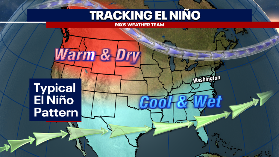
Something that has been a bit of a thorn in the side of snow lovers for the better part of the last five winters has been the presence of La Niña. Simply put, these are colder than normal waters in the equatorial Pacific that often impact the jetstream in a way that is not the most favorable for winter storms in the eastern half of the county.

Since 1950, the difference in snowfall for an El Niño winter and a La Niña winter is 18.5" for El Niño and 9.5" for La Niña. (Graphic: FOX 5 Weather Team)
The La Niña first started gathering strength through 2019-2020, and we were officially in a La Niña from the summer of 2020 through the winter of 2023. In the four winters since our last El Niño combined, D.C. picked up just 19.6" of snow total. By comparison, we got 16.9" of snow in the winter of 2018-2019 alone, our last El Niño winter. El Niño, which is where waters in the equatorial Pacific, is responsible for a more active subtropical jetstream. This more active jetstream from the tropics brings more Gulf of Mexico moisture farther northward. When it interacts with the polar jetstream, which supplies the cold air, you get the ingredients necessary for winter storms. Not all El Niño years are created equally however, and this one may have some unique characteristics that could heavily impact our winter pattern.
El Niño: Why its strength matters for DC's winter weather outlook
The stronger the El Niño does not necessarily mean the higher our risk for snowstorms and blizzards. We divide the tropical waters where El Niño is found into four sections, simply named Niño 1, 2, 3, and 4. How the warm waters are spread through these zones, and their intensity, has been found to impact what type of winter we have here in the eastern half of the country.
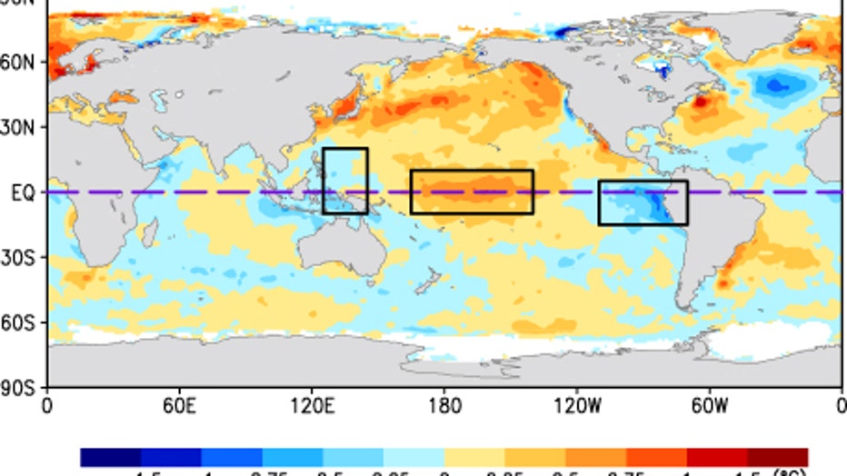
The idea setup for snow in the D.C. region, like the record-setting winter of 2009-2010 where D.C. picked up over 50" of snow, is something called a "Modoki" El Niño. This is where the waters in the central Pacific Ocean are anomalously warmer than those in the western and eastern Pacific. This type of El Niño has been present during some of the more extreme snowfall winters over the past several decades, including 2002-2003 (40.4") and 2009-2010 (56.1").
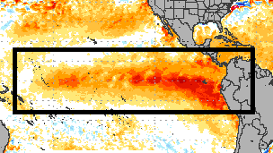
As you can see from the image above, the upcoming winter will not be a Modoki El Niño. The reason why is that water just off the western coastline of South America, known as the Niño 1+2 region, is also very anomalously warm. That being said, the Niño 3+4 region, which is the central Pacific, is also anomalously warm, but since it is not flanked by cooler waters, this is not a Modoki winter.
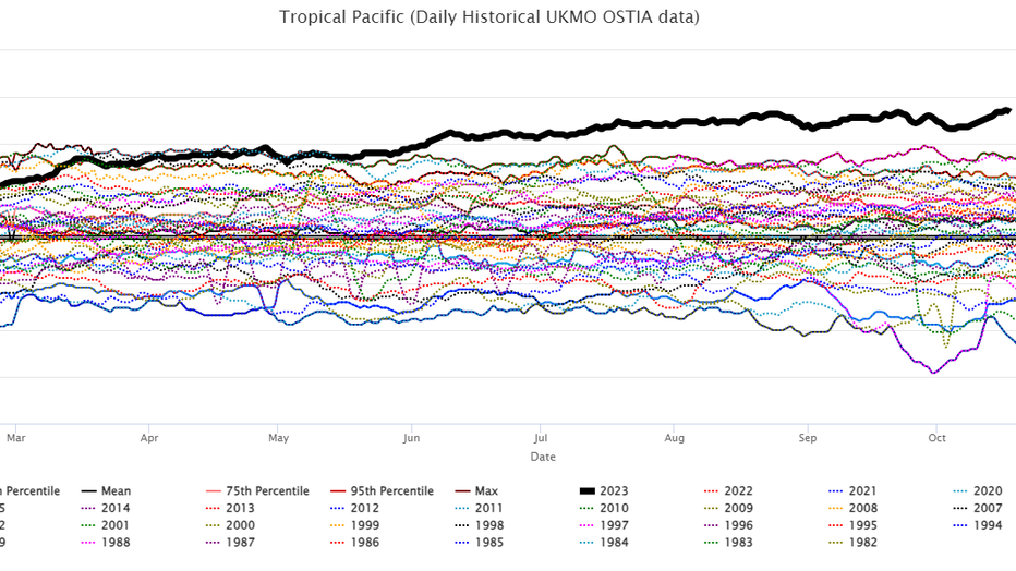
In addition, the entire tropical Pacific, including all the Niño zones, is running extremely warm – even warmer at this stage than some of the strongest El Niño years on record. This, plus climate models, tells us that not only are we heading for our first El Niño winter in about five years, but it will likely be classified as a strong to very strong El Niño as well.

This is important because while a moderate El Niño event is well correlated with colder than normal winter temperatures during the winter months in the D.C. region, the chart above shows you that strong El Niño event is strongly correlated with warmer than average temperatures across the region. However, it is also correlated with the wettest type of El Niño you can have for the DC region, averaging over ten inches of precipitation. This is due to the strong subtropical jet that we mentioned earlier in this article, which should make for a very active storm pattern. Sadly for snow lovers, that does not necessarily mean a snow-filled winter.

The above breaks down the average snowfall based on whether we are in a weak, moderate, or strong El Niño year. You can see that all of them favor above-normal snow in the D.C. area. What you can't see from just the chart though is that it is nearly a 50/50 split between whether a strong El Niño produces above or below normal snow in the DC area. On record, four have produced above-normal snow, while three have produced below-normal snow. The thing about strong El Niño winters is that because of the strong subtropical jet surging northward with Gulf warmth, you need a particularly strong surge of cold air to push the polar jet southward at the same time in order to get a good snow in a strong El Niño situation. As a result, years like this one tend to be feast or famine in the snowfall department. That is to say, it is more likely that you will get snow from one or two bigger storms, than smaller snows throughout the winter.
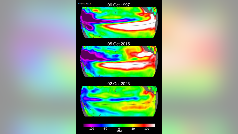
Take the last very strong El Niño winter that we experienced. That was the winter of 2015-2016, which was one of the warmest on record – the ninth warmest since records began back at Reagan National Airport in the 1940s. Still, this is not what the winter is remembered for. Instead, after a brief but strong cold snap in the middle of January, one of the most impactful blizzards to ever hit the D.C. region struck on January 22 to 23, dropping over 18" of snow. For the remainder of the winter combined, we only picked up a measly four inches of snow.
By contrast, the previous strong El Niño before that one was the winter of 1997-1998. This winter continues to be tied for the one with the least snow in DC history, with a dismal 0.1" of snow for the entire winter. So the biggest gamble with the winter forecast ahead is that it is likely to be a feast or famine type of winter in terms of snowfall. Despite the forecast for above-normal snow, we do believe that there will be more rain storms as opposed to snowstorms that come our way this winter. So the risk for a "bust" winter is there if the polar and subtropical jetstreams are unable to link up to give us a decent snow. But because we do not expect this El Niño to be as intense as those two cases (see above image) we believe that the chances for snow may at least present themselves a bit more regularly than in these previous two cases.

El Niño and PDO
Another factor we are keeping a close eye on is something known as the Pacific Decadal Oscillation (PDO). Much like El Niño and La Niña, this a pattern of sea surface temperatures across the North Pacific that can influence wind patterns and the location of the polar jetstream across the United States. A positive phase of the PDO is correlated with a more favorable storm track in the eastern United States, which can be better for snow lovers when paired up with an El Niño.

This year, while we certainly have the El Niño component, the PDO in not just in a negative phase, but average through the summer and September, it is in one of the strongest negative phases on record. As shown above, a negative phase is where warm waters prevail in the central North Pacific, while cooler waters wrap around it like a horseshoe. Not only does this configuration promote warmer than normal temperatures, but also typically drier than normal conditions in the eastern United States.
While we believe this will likely be balanced out or overwhelmed by the strength of the El Niño, if winter does end up being warm with less snow, this will likely be a reason why. Winters following falls and summers of similar PDO strength have averaged just seven inches of snow through the winter. Phases of the PDO are slow to change. The last time we were in a sustained positive phase? The last strong El Niño winter of 2015-2016, which did feature a blizzard.
Other factors for winter 2023-2024
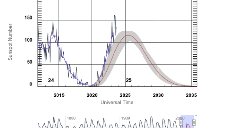
There are a number of other factors that we monitored when writing this outlook. We are nearing the peak of Solar Cycle number 25. While the correlation is not the strongest, some of the bigger snows in D.C. history have come during periods of low solar activity, such as 2009-2010.
The Snow Advance Index, which tracks snowfall expanse across the Arctic and parts of Asia and Europe, is running at near average to just below. Rapid expansion of snowfall can lead to more frequent sudden stratospheric warming events, which are linked to stronger polar blocking, which in turn means Arctic air displacement farther south during the winter months. How it expands through November can give hints on what may happen later in winter.

You’ve heard of El Niño and La Niña, but have you heard of its cousin? The Indian Ocean Dipole, or IOD, is also in one of it’s strongest positive phases in recent years. While it is much more impactful to weather in the Far East and Australia, it does impact global wind circulations which can have a trailing effect on the North American pattern. Though strong at the moment, climate models are forecasting it to weaken by the time winter arrives. Years when a positive phase of the Indian Ocean Dipole matched up with an El Niño have averaged over a foot of snow in the DC area. They feature some big winters as well, like 2015-2016 (22.2") and 1963-1964 (33.6") but also some famine winters as well, like 1997-1998 (0.1") and 1972-2973 (0.1").
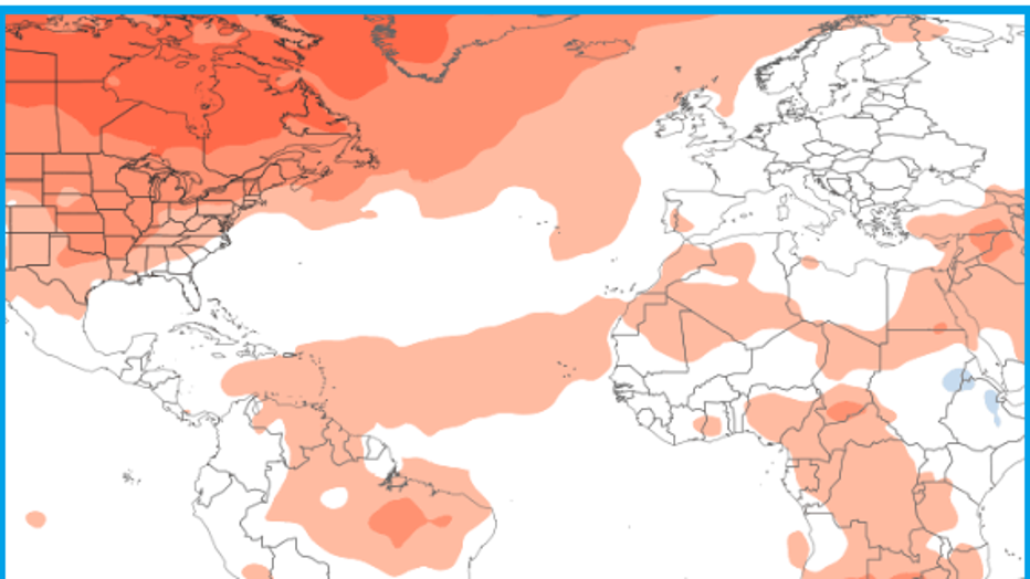
Finally, we also have to watch the ocean that is closest to us here in D.C. While the Pacific Ocean, surprisingly, is generally more impactful thanks to the fact that upper-level winds in the Northern Hemisphere always blow west to east, the Atlantic can still be very impactful in regard to patterns in the high latitudes around the Arctic. The Atlantic Multi-decadal Oscillation, or AMO, tracks sea surface temperatures across the North Atlantic region. At the moment, with Atlantic water temperatures near record warm levels, the AMO is near record levels of its positive phase as well.
This can actually have an enhancing impact on the El Niño pattern, as winters during the positive phase of the AMO are often warmer and drier across the North, while cooler and wetter across the South. The compliments El Niño perfectly. Upper-level blocks around the Poles are more common in these years. These blocks can further buckle the polar jetstream at times, which is a key component to any decent snow event along the East Coast.
FOX 5 Forecast: Winter 2023-2024 in the DMV
So what does this all mean for the Mid-Atlantic and Washington, D.C. region? The short answer is, we expect that this winter is going to be a warm one. Even weaker El Niño winters are typically warm at the start of winter, so we expect that December will come in with above-average temperatures. This does not mean shorts and t-shirt weather, but the threat for a December to remember blizzard, such as the one that hit in December of 2009, is well below normal. The colder months, relative to their average, are likely to be January and especially February.

There have been eight strong El Niño winters, and four of them have brought plenty of snow to the DMV. (FOX 5 Weather Team)
This has in large part to do with the type of El Niño it is. As we highlighted above, the majority of major snow winters occur during moderate El Niño. This is because the southern subtropical jet, which both supplies the moisture for storms, is not "supercharged" to the point it can overwhelm the polar jet, which provides the cold. One of the strongest correlations that we have as far as strong El Niño is that the vast majority, five of the seven cases historically have featured well above normal temperatures in the D.C. area. With the PDO being strongly negative as well, this just adds to the confidence that the winter as a whole will be warm-leaning. This does not mean that we do not expect any cold at all. The Atlantic AMO pattern suggest periodic bursts of Arctic blocking that we have also seen at times through the summer and fall months. This should bring the cold in "waves," but we think that the threat for prolonged periods of cold is very low this winter.
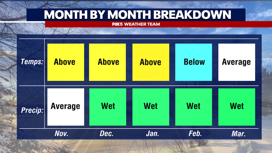
Winter 2023-2024 month by month breakdown (FOX 5 Weather Team)
Note that a strong subtropical jet means we are expecting that this will be a stormy winter in the eastern United States. Stormy, however, does not necessarily be snowy. Most of the larger storms that come our way this winter will be rain events. In any winter, it rains more than it snows in the D.C. area, but this will likely be exacerbated with the strong El Niño in place.
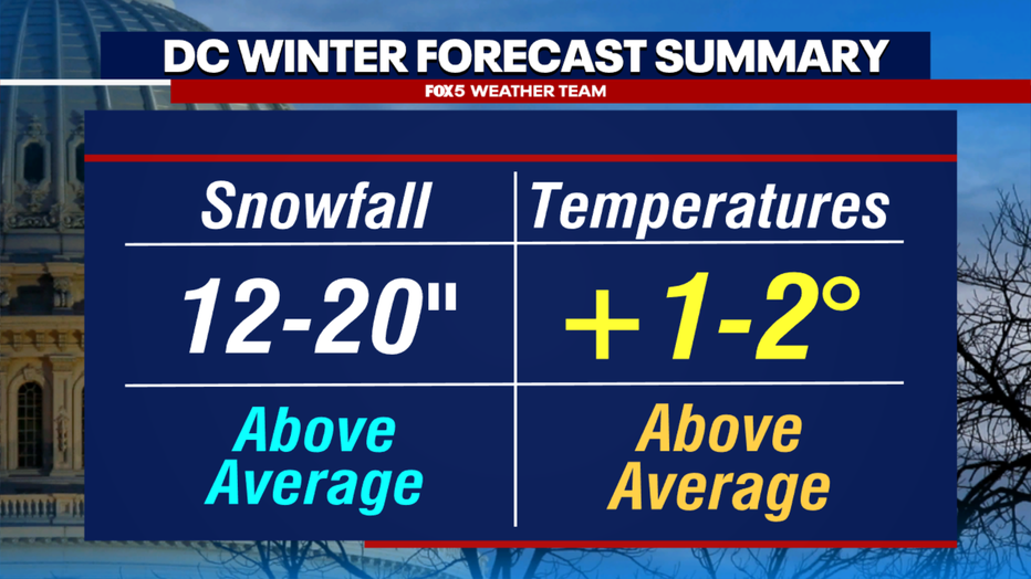
DC Winter forecast summary: Above average snowfall of 12-20 inches, temperatures one to two degrees above average. (FOX 5 Weather Team)
Despite all this, we are still going with above-normal snow for the winter ahead. Why? Because as the winter of 2015-2016 proved, all it takes is one storm around here to make for an above-normal season. That being said, this is obviously the part of the forecast that makes us the most nervous. We expect our best chances for snowfall would come in the second half of winter--the second half of January through the first half of March. This is when the polar jet is climatologically at is strongest. We believe that periodic burst of cold air will provide the opportunity for a snowstorm or two this winter.
As with every winter, the threat for a bust exists. There have been several strong El Niño winters with very little snow, like 1997-1998 (0.1") that are risks to the forecast. As far back as records go however, D.C. has still never had a completely snowless winter. The opportunities for snow should present themselves several times in the winter ahead.
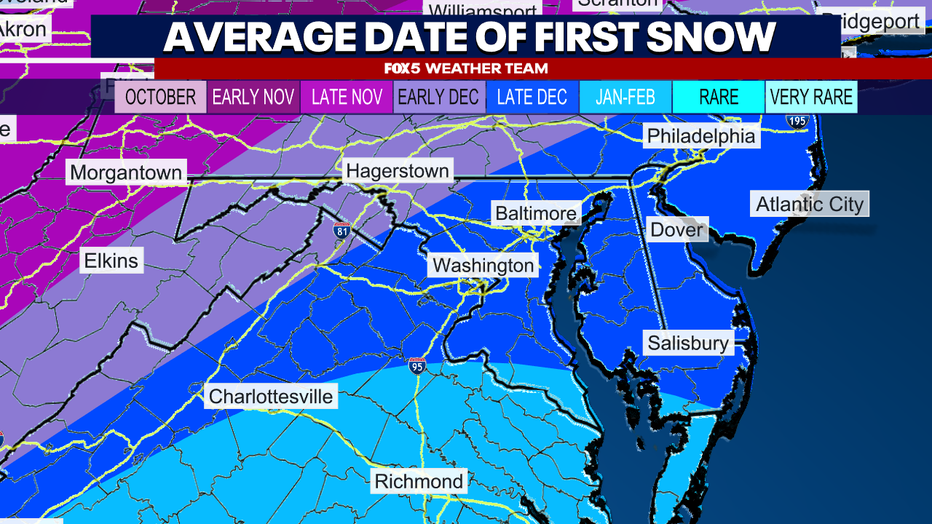
Average date of first snowfall in the DMV-Washington and Baltimore typically see the first measurable snow in late December, while Richmond typically sees the first snowfall in January-February. Hagerstown falls on the earlier side, in early December
How soon could it snow in DC?
Winter officially begins on the shortest daylight day of the year, the winter solstice, on December 21st this year. Typically, the first measurable snow falls during the latter half of December here in D.C., but we would not be surprised if it came later than normal this year
And there you have it. Your FOX 5 Weather Forecast for the winter ahead!
Now look, this forecast will undoubtedly be less than perfect as seasonal forecasting is notoriously difficult, as no two winters are exactly the same. This one will contain its own surprises, and the Fox 5 Weather Team will be here to help you through each of those surprises as they come..

