Could a blizzard hit the DC area this weekend? Here’s what we know

Could another snowstorm impact DC region this weekend?
Weather models hint at a significant snowstorm later this week, potentially bringing blizzard conditions, though uncertainty remains. FOX 5 meteorologist Mike Thomas has the latest forecast.

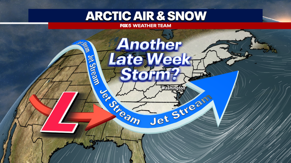
A storm in the south later this week has a shot to ride the jetstream northward, bringing more snow to the Mid-Atlantic & Northeast
Record-breaking snowfall?
D.C. is recovering from one of the city's largest snowfalls in the last decade.
Reagan National Airport saw 7.2 inches, making it the city's largest snowfall since almost seven inches fell in early January 2022.
While D.C. did not break a record, which was nine inches set back in 1892, both Dulles, VA, and BWI in Baltimore did set new snowfall records with nearly half a foot at each location.
Some of the coldest air of winter has come down from Canada as well and will be sticking around. This means the snow that fell Monday will not be melting away anytime soon.
It also means the threat of ice, especially during the evening and early morning hours when temperatures are expected to be well below freezing. So, even if a road appears clear, we still urge travelers to use extra caution.

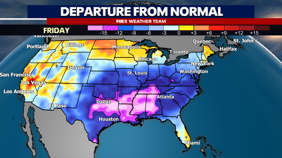
Weather models show well below normal temperatures across the eastern half of the country through this entire week.
‘Double hitter’ two storms in D.C. this week
With the cold going nowhere, our eyes begin to turn towards the future, and whether the District could be impacted by a "double hitter", that is, two snow storms over the course of a single week.
The answer to that question is yes, we absolutely could. It has happened before as well. Famously back in February 2010, D.C. picked up 17.8" of snow on the 5-6th of February, followed just two days later by another 10.8" of snow on the 9th-10th of February.
Should it come to fruition, the storm later this week could have much higher snowfall totals, ones that could rival those February cases. But even inside five days, there are still some major differences in the weather modeling, and questions about whether a storm will even happen in our region.

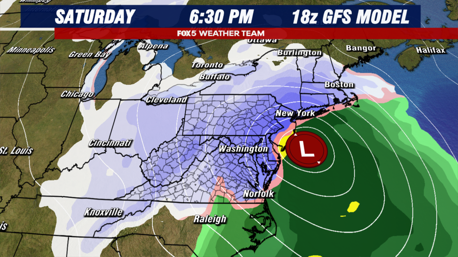
A snapshot of the American Weather Model (GFS) showing a forecast of heavy snow in the Mid-Atlantic & Northeast this weekend.
Blizzard expected to hit DC region Friday, Saturday
The American model is the one that has been making all the rounds on social media. For the better part of the past two days, it has been showing – well, let's be frank here – a blizzard for the D.C. region Friday night through Saturday. Storms like the one modeled here tend to give people in the region not just multiple inches of snow, but the potential for feet of snowfall.
What makes a winter storm a blizzard?
Why would this be considered a blizzard when Monday's snow was just a winter storm? The primary reason is that, at least in this model, the storm is a strengthening wave of low pressure up the coastline.
As a storm strengthens, it produces strong winds. Strong winds blowing snow reduce visibility, and this is the most important criterion needed for issuing a blizzard warning.
When was the last blizzard in D.C.?
D.C. has not had a blizzard watch or warning since the late January blizzard of 2016.

A snapshot of the American Weather Model (GFS) showing a forecast of heavy snow in the Mid-Atlantic & Northeast this weekend
European model forecast
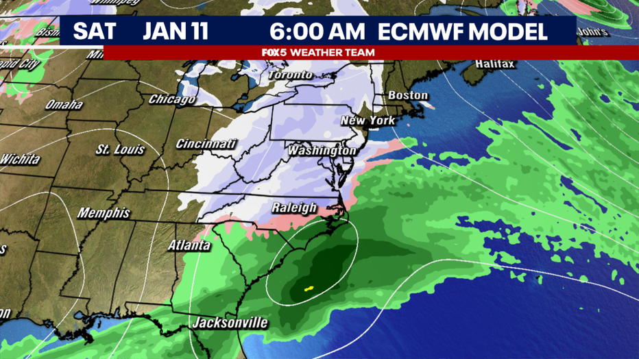
With such a strong signature from the American model, why did I say that there is a chance no storm could form at all? Well, that's because of how the model differs from what is shown by its counterpart, the ECMWF, commonly called the European model.
The American model shows what is known as a phase. It is where a storm from the south links up with energy in the northern jetstream, creating a powerful nor'easter that turns northward up the coastline.
Recent runs of the European, which arguably performed better with Monday's snowfall across the D.C. region, have suggested that this connection will not actually happen. Without this phasing, the storm remains considerably weaker, and drifts across the southeast and then out to sea. It does still show a period of potential light snowfall on Saturday morning, but these amounts are considerably less than its American model counterpart.
So which is correct?
The answer is, we are honestly not sure yet.
The devil is always in the details with a larger storm and small shifts in how either model sees the upper air energy that will create this storm means big differences in how it will track.
The FOX 5 Weather Team will continue to keep you ahead of the second possible storm as we examine new data coming in. Models will likely be in much better agreement by Wednesday or Thursday about whether we are heading for our second major snowstorm in a week, or a much more manageable, weaker system.
The Source: FOX 5 meteorologist Mike Thomas provided the information for this story.


