DC heat wave: Record temperatures possible as summer begins

Heat dome, heat wave, to hit DC region this week
It is not officially summer just yet – at least not until Thursday – but the D.C. region is already preparing for what could be one of the hottest stretches of weather for the entire summer ahead. FOX 5's Mike Thomas has the forecast.
BETHESDA, Md. (FOX 5 DC) - It is not officially summer just yet – at least not until Thursday – but the D.C. region is already preparing for what could be one of the hottest stretches of weather for the entire summer ahead.
Temperatures surpassed the 90°F threshold on Monday for the start of what is expected to be a long-duration heat wave across the D.C. region.
The National Weather Service officially defines a heat wave in our region as three or more days in a row where the air temperature reaches at least 90°F. A term you are likely hearing used a lot is "heat dome," but what exactly is a heat dome?
What is a heat dome?
A "heat dome" is defined as an exceptionally hot air mass that develops when high pressure aloft prevents warm air below from rising, thus trapping the warm air as if it were in a dome. Strong areas of high pressure develop in areas of the atmosphere where air is converging, causing broad areas of sinking air in the middle atmosphere. This sinking can prevent widespread cloud cover along with showers and thunderstorms from developing each afternoon, leading to prolonged periods of hot, dry, sunny weather at the surface.
Our region will be under the influence of one of these heat domes this week.
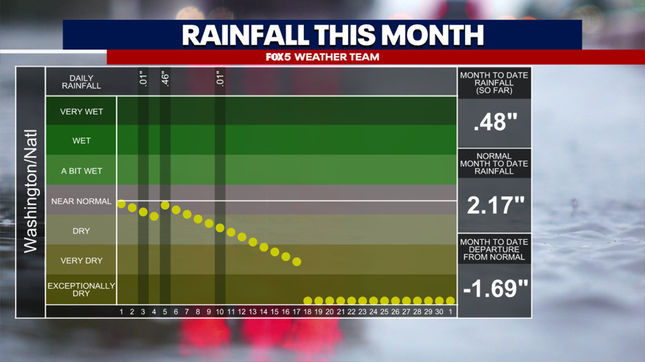
In addition to the heat dome, another aspect of the pattern that is a concern is just how dry we have already been this month. Quite the opposite of May, where we seemed to be dodging showers and thunderstorms throughout the month. Less than half an inch of rain has fallen so far this month, well below normal.
Most of that fell on one day as well, June 5, the day of the tornado outbreak around the D.C. region.
READ MORE: DC activates Heat Emergency Plan, cooling centers amid extreme heat
Dry soils are easier to heat compared to moisture-rich soils, and thus the longer the dry pattern persists, the hotter the temperatures could rise as the ridge peaks later in the week.
Heat advisory possible in DC?
It is the end of the week when temperatures are expected to peak.
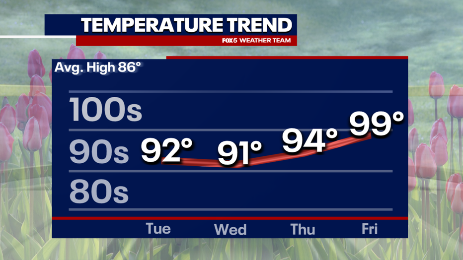
While the heat wave likely officially began with Monday's high of 91°, heat during the front half of the week will be rather manageable — mostly lower 90s.
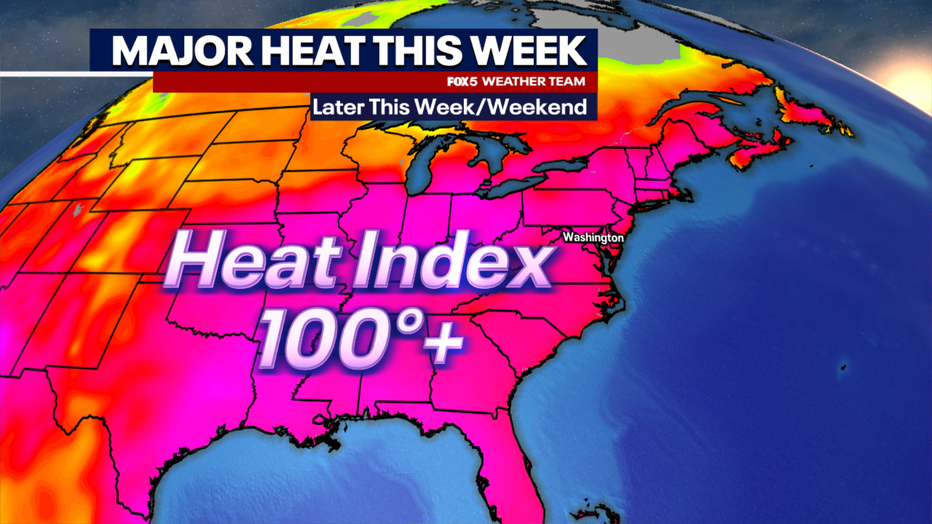
D.C. is not expected to hit "heat advisory" levels (where the heat index could exceed 105°F) until the second half of the workweek, so the heat wave will have a relatively gentle start. However, by the weekend, heat could reach downright dangerous levels.
Will temperatures reach 100 degrees in DC?
Rather ironically, the first few days of summer will be the hottest of the entire heat wave, with temperatures that were typical of the hottest of the entire summer in previous years.
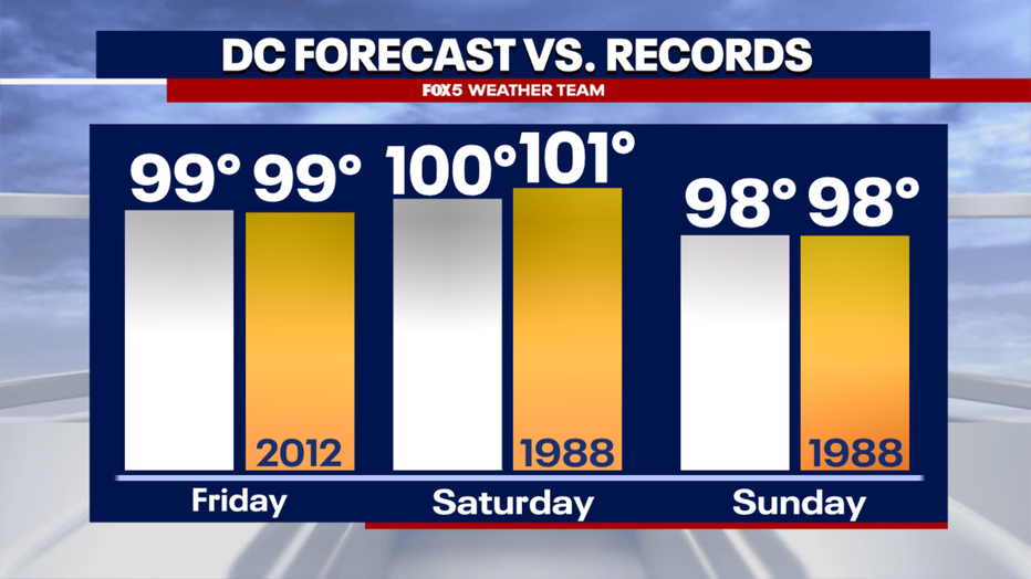
Records will likely be challenged and perhaps surpassed around our region on Friday, Saturday, and Sunday as the mercury soars into the upper 90s.
Featured
Heat wave could bring triple-digit temperatures to DC next week
Could D.C. see its first 100° day in years next week?
Even triple digits will be possible, a mark that has been rather elusive in recent years.
For as hot as recent summers have been, D.C. has not seen a 100°F day since August 2016. Whether we do will likely depend on just how much humidity is present this weekend.
Humid air, though making it feel like well over 100°F, is harder to heat than drier air, and thus, while weather models can show triple-digit potential, it can sometimes be harder than they indicate to hit this level.
Still, it is expected to be close. D.C. will run the risk of excessive heat warnings this weekend, meaning the heat index (real feel) values could exceed 110°F.
Be sure to have a plan to stay cool!
How long will the heat wave last in the DC region?
The question then turns to how long can this heat wave last.
The most extreme numbers in the upper 90s should only last for four days or so later this week. But what about the 90s?
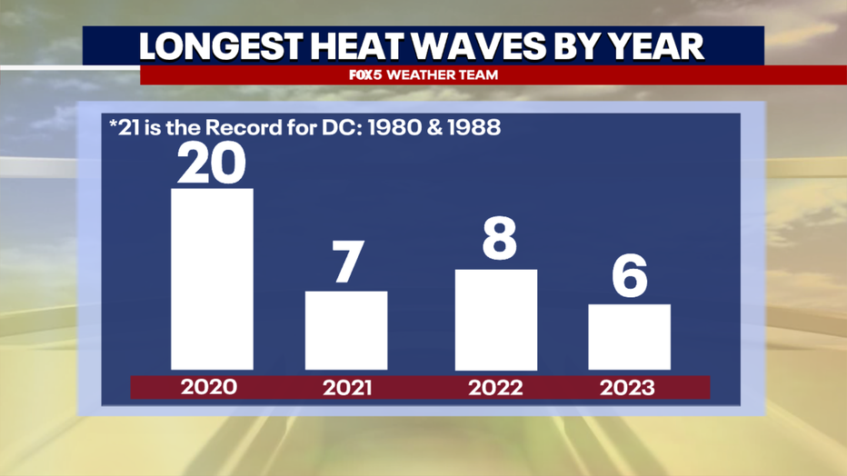
In recent years, the longest heat waves each summer were typically around a week in length.
A notable exception is 2020, where in late June through the middle of July we recorded twenty straight days of 90°F temperatures. This was the third-longest stretch ever recorded in D.C. history.
Some models suggest we may get closer to that number with this particular stretch of hot weather. It also does not help that this heat wave is coming just ahead of D.C.'s typical hottest time of the year.
In fact, the average high temperature in D.C. hits 90°F on July 6.
Whether this could be a stretch that goes for the record books could largely depend on how dry our region stays in the weeks ahead.

One thing that we do know is that the pattern is going to weaken next week, as the "heat dome" pattern shifts over towards the Southwest United States.
This will introduce more northwest flow into the middle atmosphere, with less subsidence, allowing for greater potential for showers and thunderstorms.
READ MORE: Major heat wave on the way for DC, Maryland, Virgina
While the shift in the upper atmosphere alone will put an end to the most extreme temperatures, whether it will put an end to our streak of 90-degree weather will remain to be seen.
Several of the most accurate longer-range weather models suggest that 90° temperatures could linger the rest of the month and go right into early July.
Severe thunderstorms possible after DC heat wave
Others suggest that thunderstorm variability will at least occasionally keep our temperature from hitting that mark.
In this regard, it is a wait-and-see type of situation.
We rarely break a heat wave without one or two stronger thunderstorm days though, so watch for severe weather risks as the ridge weakens next week.
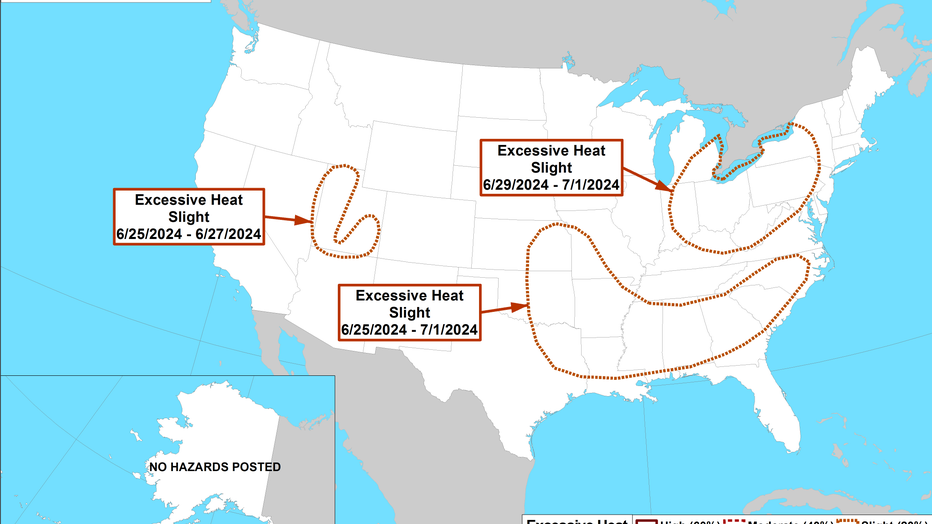
There is the risk, however, that any break may be short-lived, with NOAA's Climate Prediction Center already highlighting parts of the Midwest, Northeast, and Mid-Atlantic, including us in the D.C. region, as being at risk of another strong heat wave near the end of the month.
As we mentioned in our summer outlook, summers where we are transitioning from an El Niño to a La Niña pattern have historically run very hot in the eastern half of the country, especially since the turn of the century.
Early indications are that summer ahead may fit into that mold.
Count on the Fox 5 Weather Team to keep you ahead of anything that the summer sends our way!


