Heat wave could bring triple-digit temperatures to DC next week

Intense heat wave expected in DC: 100-degree weather Possible
Despite the late-week heat, many forecasters are already sounding the alarm that next week's heat wave could be one of the strongest in recent memory here in the D.C. region. FOX 5 meteorologist Mike Thomas has the forecast.
Summer is a little over a week away, but it could come in with a vengeance as an intense ridge of high pressure is forecast to settle over the eastern half of the country next week.
So far in 2024, D.C. has seen the mercury exceed 90°F just once, back on May 2, when we reached 91°F.

Despite that, what forecasters call "meteorological spring" (March, April, and May) is still verified as the third-warmest on record in the D.C. region.
After a relatively tame start to June, summer heat will build quickly, with the middle 90s even possible by Friday of this week, before the 80s return for the weekend.
Despite the late-week heat, many forecasters are already sounding the alarm that next week's heat wave could be one of the strongest in recent memory here in the D.C. region.
In 2023, the hottest temperature in June was just 94°F, a figure we may surpass before the end of this week.
READ MORE: DC breaks January heat record
The longest and most extreme heat wave of 2023 was actually in September. Starting September 3, D.C. had six straight days of 90°+ temperatures, with five of them exceeding 95°F.
The heat wave peaked at 99°F on September 5th.

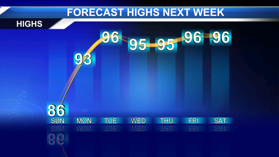
Current model projections suggest that the upcoming heat wave may have the potential to exceed the length of that September heat wave, with temperatures in the 90s potentially remaining through not only next weekend but into the following week.
The uncertainty in the forecast is whether any thunderstorms could provide some cooling relief in the forecast period. Conditions underneath intense heat ridges like the one forecast next week are often abundantly sunny due to sinking air in the middle atmosphere limiting cloud cover, but with high humidity levels and strong surface heating, pop-up storms could fire each afternoon, particularly as the ridge starts to weaken.
With the extreme heat, severe weather would be possible on days when this occurs, but it is too early to pinpoint any day that would be a risk.

NOAA's Climate Prediction Center has already warned that the heat in the D.C. region could be what they call "excessive" during the middle of next week. Excessive Heat is defined as a heat index, which is the "feels like" temperature that accounts for humidity, of 110°F or greater east of the Blue Ridge, and 105°F or greater west of the Blue Ridge. A watch is used when the risk of excessive heat waves has increased, but its occurrence and timing are still uncertain. The warning is used for high heat conditions that pose a significant threat to life.
READ MORE: DC weather: Temperatures could reach 90 degrees with threat of thunderstorms next week
The D.C. area has not seen excessive heat alerts since late July 2023, when the temperature hit 97°, but the heat index climbed to nearly 112° in a few locations.

How hot could it get in DC?
The vast majority of guidance suggests that we could see a prolonged period in the middle to upper 90s next week. This alone will be enough to activate the District's Heat Emergency Plan which is activated anytime the air temperature or heat index exceeds 95°F.
Residents should plan now if they need access to cooling centers, and sensitive at-risk groups should avoid the outdoors during the peak heating hours of the afternoon (1 p.m. – 5 p.m.).
Some models suggest that D.C. could even see its first 100° day in years.

DC Heat Emergency Plan activated as temperatures in the 90s expected; cooling centers open
Washington, D.C. has activated its Heat Emergency Plan. The District says it enters a heat emergency when temperatures or the heat index – a gauge of how hot it feels outside based on the temperature and humidity –reaches 95 degrees.
D.C. has not seen a triple-digit air temperature day since August 15, 2016.
There have been close calls though, as the city has hit 99°F a total of five times since that date! Could this heat wave be the one to end the streak?
Count on FOX 5 to keep you up to date with the latest forecast all summer long.


