

DC heat wave could linger into July, 100-degree weather expected this weekend
For the third straight day, high temperatures in D.C. have hit 90°F or greater, officially marking the start of the first heat wave of the year in 2024.
All of this before even the official start of summer, which kicks off on Thursday in the Northern Hemisphere with the longest daylight day of the year.
There will be 14 hours and just about 54 minutes of daylight on Thursday, and one thing is for sure, the vast majority of them are going to be hot.
Has the heat dome reached the D.C. region?
Despite already being the hottest week of the year so far, the actual "heat dome" that you have heard so much about is not even present just yet.
It is only in its early stages of development.
This ridge of high pressure in the middle atmosphere is just beginning to strengthen and will peak over the Mid-Atlantic region heading into the end of the workweek.
This means our hottest temperatures are still yet to come, and we could be in record territory for the very first weekend of summer.
What is causing the heat wave in DC?
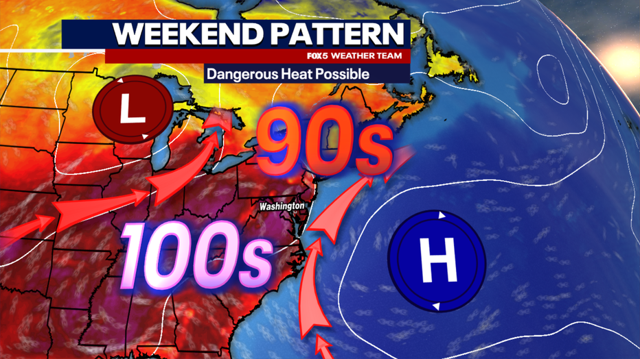
At the surface, a feature known as a Bermuda High will be present off the East Coast.
It has been there all week, though it has been centered on more of the New England coastline during the early part of the workweek.
By the end of the week, this feature will shift to the south. At the same time, a wave of low pressure will develop over the Northern Plains and push eastward through the Great Lakes.
This is important to our region because both of these features will work in tandem to turn winds in a more south-southwesterly direction.
This, combined with the heat dome overhead, is expected to usher in extreme heat and humidity into the D.C. region.
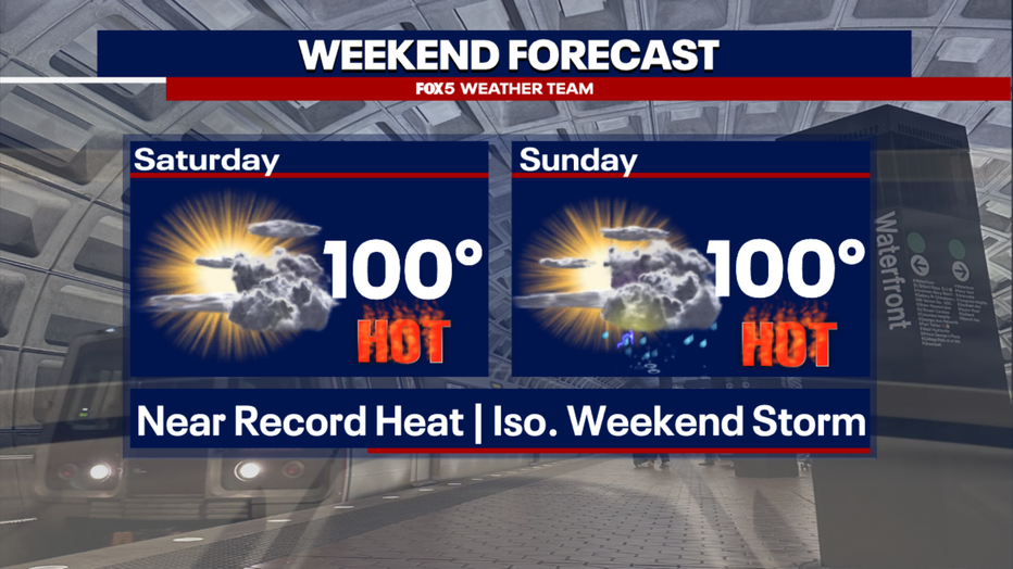
DC weekend forecast: 100-degree weather on Saturday, Sunday
By the weekend, temperatures will soar into the upper 90s, and potentially even triple digits.
As of Wednesday afternoon, the FOX 5 Weather Team is officially calling for the elusive 100°F mark for D.C. on both Saturday and Sunday afternoons.
I say elusive because hitting the century mark is not something that D.C. has done very often in recent years.
When was the last time it was 100 degrees in D.C.?
You have to go back eight summers to the last time that D.C. saw the mercury hit 100°F+, to August 15, 2016.
Since the turn of the century in 2000, D.C. has hit 100°F or greater just 25 times, with 17 of those days coming during the extremely hot summers of 2010-2012.
Triple-digit heat is so rare in D.C. mostly because of where we measure D.C.'s official high temperatures, at Reagan National Airport right next to the Potomac River.
Any wind off the river at all can play a huge role in the temperature reading, often keeping us cooler than surrounding areas even if those areas are all well above 100°F.
DC heat alerts
Heat will not be the only concern here in the D.C. region, but an extreme heat index, which is a measure of what the temperature feels like when combined with humidity, will be possible as well.
Friday through Monday will be the most extreme heat in the short term, with Sunday having the unfortunate distinction of being the "worst of the worst."
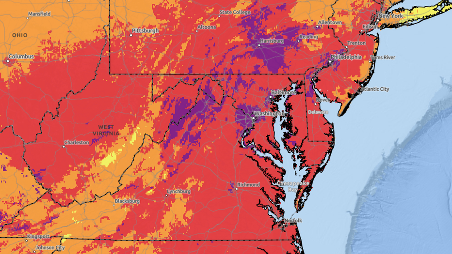
The National Weather Service (NWS) is noting that heat-related impacts are expected to be greatest on Sunday, when excessive humidity could get the heat index into the 105-110°F range, enough for rare excessive heat alerts in the D.C. region. The NWS Heatrisk analysis is forecasting level 4, magenta level extreme heat risk on Sunday afternoon, their highest level of concern. According to NWS, this level is issued for rare and/or long-duration extreme heat events with little to no overnight relief that will impact anyone without effective cooling and/or adequate hydration. Impacts likely in most health systems, heat-sensitive industries and infrastructure.
Featured

DC heat wave: Record temperatures possible as summer begins
Records will likely be challenged and perhaps surpassed around our region on Friday, Saturday, and Sunday as the mercury soars into the upper 90s.
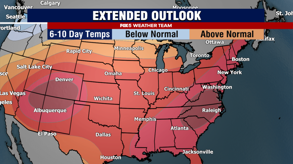
By the end of the weekend, the upper level high that is responsible for the more extreme heat will shift westward, towards the Desert Southwest of the United States.
The shift in this feature does not necessarily mean cooler temperatures, but does mean that more instability will be present across the Midwest, Northeast, and Mid-Atlantic regions. Models show an upper atmospheric trough sweeping the region on Sunday afternoon and evening.
Similar to waves in the ocean, air ahead of this feature is more susceptible to rising motion, and thus thunderstorms will become more likely later in the day on Sunday.
In such a high heat, high humidity environment, and storms that cause fire fires, Sunday will have the threat of becoming severe, so be warned if you do have pool or beach plans this weekend that scattered storms could interrupt activities by the evening hours.
Just because the "heat dome" shifts west, does not mean it is the end of our heat wave though.
In fact, many weather models suggest that this may just be the beginning.
Some models suggest that two more "pulses" of stronger heat are possible, one in the middle of next week with another centered around the final weekend of June where temperatures could again hit the upper 90s or possibly approach 100°F again.
Many models keep the high temperature in D.C. above 90°F every day, though at least the fourth of July holiday, possibly even beyond that.
Record-breaking heat wave in DC possible
If we do indeed keep this heat wave going through the fourth of July, that would be at least eighteen straight days of temperatures above 90°F.
Now, there are unknowns in that time period.
Could cloud cover, rain, or thunderstorms keep D.C. from hitting 90°F on a particular day?
Could a more easterly wind off the Potomac River limit heating on a day?
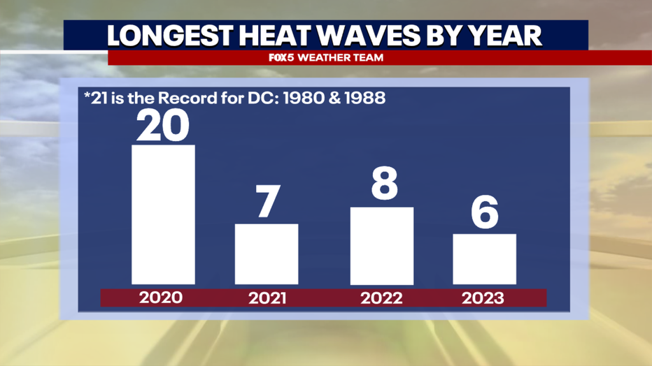
Those are details that we will have to monitor for in the weeks ahead. However, if we do indeed see the 90s persist into the upcoming Independence Day holiday, we could quickly be approaching record length as far as the longevity of the heat wave is concerned, at the very least the longest in four years.

Heat dome, heat wave, to hit DC region this week
It is not officially summer just yet – at least not until Thursday – but the D.C. region is already preparing for what could be one of the hottest stretches of weather for the entire summer ahead. FOX 5's Mike Thomas has the forecast.
Back in 2020, we had a 20-day stretch of 90°F+ heat that lasted through late June into early July, the third longest such stretch on record.
The standing record is at three weeks, which D.C. has done twice before, back in 1980, and 1988.
I think most would agree that these are records we would rather not see broken.