

Tropical Depression Debby brings tornado threat to DC region

Tornado warning issued in West Virginia
A tornado warning was issued in parts of West Virginia Thursday night as the remnants of Tropical Storm Debby approach the northeast. FOX 5 Meteorologist Mike Thomas is tracking the storms.
BETHESDA, Md. (FOX 5 DC) - Severe weather has led to tornado warnings across parts of Virginia and Maryland as Tropical Depression Debby slowly moves up the Eastern Seaboard.
Tornado warnings in Northern Virginia
A tornado warning is in effect until 10:15 p.m. for west central Loudoun County.
The National Weather Service in Sterling, Virginia, issued a tornado warning for several areas in northern Virginia, southeastern Clarke County, and north central Fauquier County. That warning was in effect until 9:30 p.m.
At 9:07 p.m., a severe thunderstorm capable of producing a tornado was detected near Middleburg, approximately 12 miles west of Brambleton. The storm moved northwest at 35 mph.
A tornado warning was in effect for north central Stafford and south central Prince William counties until 8:30 p.m., as the National Weather Service reported a severe thunderstorm with the potential to produce a tornado was detected at 7:54 p.m.

Debby remnants reach Northern Virginia counties; tornado warnings issued
FOX 5 meteorologists Caitlin Roth and Mike Thomas track Tropical Storm Debby and the possible tornadoes forming across the D.C. region.
The storm was located seven miles west of Stafford, moving northwest at 35 mph.
Residents in the Fredericksburg, Virginia area were urged to remain alert as the tornado-warned cell, which has strong rotation, was heading in their direction.
The National Weather Service in Sterling, Virginia, also issued a Tornado Warning for southeastern Fauquier County in northern Virginia, effective until 8:45 p.m.
Just before 8:15 p.m., a severe thunderstorm capable of producing a tornado was detected nine miles southeast of Bealeton, or 13 miles west of Stafford. The storm was moving northwest at 35 mph, posing a serious threat to the area.
A tornado watch has been issued for the Washington D.C. metro area, including dozens of Virginia counties such as Culpeper, Spotsylvania, Prince William, Fairfax, and Stafford until 7 a.m. Friday as a band of heavy rainfall continues to impact the region.
A tornado warning was issued Thursday evening for Montgomery County until 6 p.m.
The warning was issued after enough rotation was detected within the storm system, prompting immediate action for those in the affected area.
What areas are affected by the Montgomery County tornado warning?
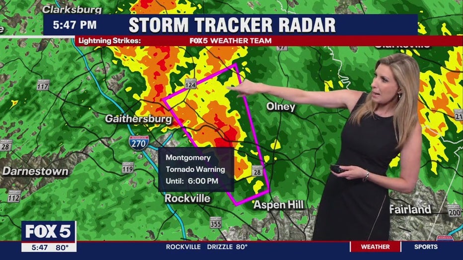
The storm, which has been producing heavy rain across parts of the county, particularly along and east of Interstate 270, has shown signs of rotation that have raised concerns. Residents in Redland and a small sliver of Montgomery County just north and west of Aspen Hill, including Route 28 and up to Route 124, are urged to take shelter immediately.
FOX 5 meteorologist Caitlin Roth says the affected areas, include Avery, Sycamore Acres, Manor Park, and neighborhoods near Route 200. The storm is moving north-northwest, placing communities between Gaithersburg and Olney, including Redland, in the path of potential tornado activity.

Debby brings tornado warning to Montgomery County
A tornado warning was issued for Montgomery County until 6 p.m. Thursday. FOX 5's Weather team is tracking Tropical Depression Debby.
Roth says the storm doesn’t show the traditional hook often associated with tornadoes. Instead, it features what is known as an "S curve" within the cell, indicating wind patterns that could result in rotation.
Roth says this is not your typical weather event. The rotation in the winds is causing these cells to produce tornadoes without the usual storm signs.
Featured

Debby Tracker: DC forecast cone map, path, live radar, rainfall totals
Track Tropical Storm Debby’s impact on the D.C. region with live radar, forecast cone maps, path tracker, rainfall total, radar loop, and the updated forecast.
A FOX 5 Skycam near Rockville captured images of the storm, showing significant movement within the cloud deck. The camera provided a view of the lowering cloud base, which Roth noted as an indicator of potential tornado formation.
This storm is parallel to Interstate 270, with a velocity couplet detected just east of Rockville, indicating rotation.
Residents along Bowie Mill Road and Applewood Lane should be especially cautious as the storm passes.
What time does the Montgomery County tornado warning expire?
As the evening progresses, more tornado warnings may be issued.
The current warning, set to expire at 6 p.m., is just one of many possible warnings as the storm system continues to move through Montgomery County and beyond.
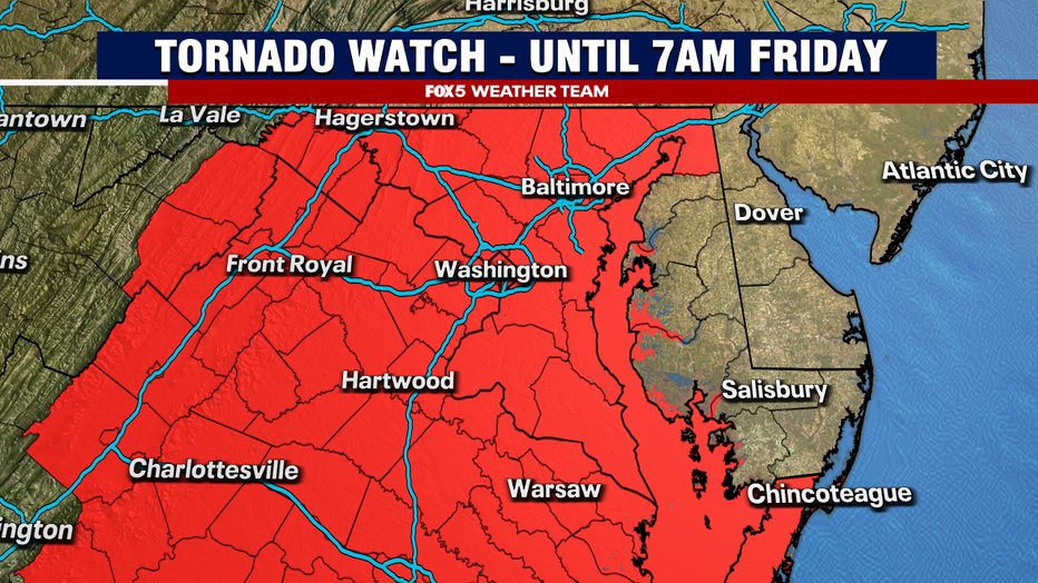
Virginia counties included in Tornado Watch
- Accomack
- Albemarle
- Amelia
- Amherst
- Appomattox
- Arlington
- Augusta
- Brunswick
- Buckingham
- Campbell
- Caroline
- Charles City
- Charlotte
- Chesterfield
- Clarke
- Culpeper
- Cumberland
- Dinwiddie
- Essex
- Fairfax
- Fauquier
- Fluvanna
- Frederick
- Gloucester
- Goochland
- Greene
- Greensville
- Halifax
- Hanover
- Henrico
- Isle of Wight
- James City
- King and Queen
- King George
- King William
- Lancaster
- Loudoun
- Louisa
- Lunenburg
- Madison
- Mathews
- Mecklenburg
- Middlesex
- Nelson
- New Kent
- Northampton
- Northumberland
- Nottoway
- Orange
- Page
- Pittsylvania
- Powhatan
- Prince Edward
- Prince George
- Prince William
- Rappahannock
- Richmond
- Rockingham
- Shenandoah
- Southampton
- Spotsylvania
- Stafford
- Surry
- Sussex
- Warren
- Westmoreland
DC flood watch
Additionally, a flood watch is in effect for the D.C. metro area, with heavy rain expected to continue through the night and into the early morning.
The National Weather Service is monitoring the situation closely. They reported a funnel cloud near the Grosvenor Metro station, though no ground touchdown has been confirmed.
We’re seeing the rotation stretch out and weaken, so the tornado warning is expected to expire soon.
Residents are advised to remain vigilant and prepare for possible renewed tornado threats later in the night, along with potential flash flooding.
As always, if a tornado warning is issued, take shelter immediately, preferably in a basement or an interior room on the lowest floor of a sturdy building.
Eastern West Virginia, northern and central Virginia, and central and western Maryland flood watch
A Flood Watch is currently in effect for the entire Eastern West Virginia, northern and central Virginia, and central and western Maryland. The National Weather Service says scattered to numerous instances of flooding are possible, especially on Thursday night.
There is a considerable threat of flash flooding for areas near the Blue Ridge Mountains.
This is a developing story. Check back with FOX 5 for updates.