

Thanksgiving travel troubles: Rain, wind could make Tuesday a travel nightmare in DC region

Thanksgiving travel alert: Rain, wind forecasted to disrupt Tuesday's DC region commute
The Thanksgiving travel season is upon us, but unfortunately, so is Mother Nature’s fury.
BETHESDA, Md. (FOX 5 DC) - The Thanksgiving travel season is upon us, but unfortunately, so is Mother Nature’s fury.
We have had a very dry pattern across the D.C. region. In fact, it has been nearly two months since late September brought us our last soaking rain. But as the influence of a moderate to strong El Niño ramps up across the United States, there are signs that that pattern is about to change.

FOX 5 Weather forecast for Tuesday, November 21
Taylor Grenda has the FOX 5 Weather forecast for Tuesday, November 21
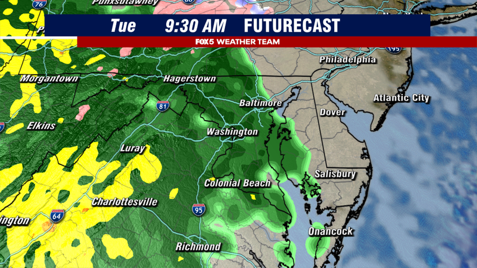
It all starts early Tuesday, likely around the morning commute, as rain overtakes the region from our southwestern areas first, to our northeastern areas throughout the morning. Those up around sunrise may escape with an hour or two of dry weather, but when the rain does pick up, it may not let up for much of the day.
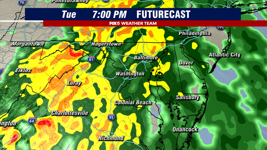
As the day goes on, and the storm system gets closer, even more atmospheric moisture will flood into the region. The thing about this setup that becomes more and more common as we get into the colder months of the year, is it is what we call a cold air damming setup. This is where heavy, chilly air gets trapped at the surface and can act like a ramp in the atmosphere. As the moisture runs up and over this heavy, cooler air, it can increase rainfall rates. So it is likely to be heavier as the evening rush hour starts than during the morning commute.

Just ahead of the front passage late Tuesday night into Wednesday morning, Futurecast is even suggesting enough instability for the isolated thunderstorm to get embedded within the rainfall. Indeed, the Storm Prediction Center has outlined the D.C. area and our southern suburbs for the thunderstorm potential Tuesday, although these should be isolated.
The rain should wrap up in the overnight hours, with drying and some clearing expected for sunrise on Wednesday.
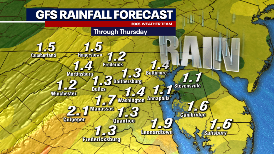
On the positive, this is much-needed rain for our region. Much of our region is running abnormally dry through the fall, and western zones near the I-81 corridor are in a severe to extreme drought. This rain is welcome, just not something that will make for great travel.
Expect delays both on the wet roadways and in the air.
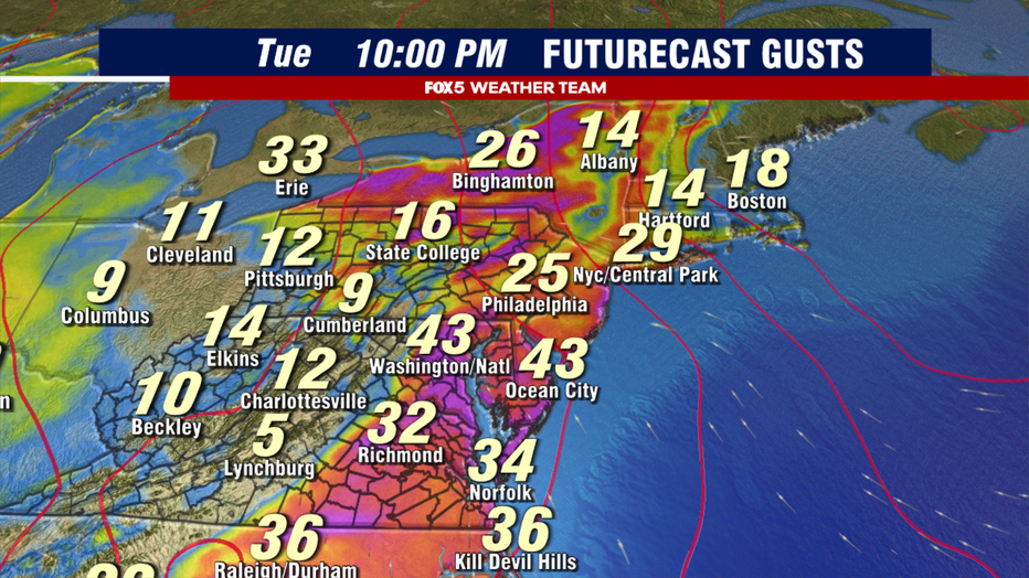
Heavy rain can, of course, delay air travel in itself, but what may be a bigger concern is the gusty and shifting winds, which is typically what causes most of the delays when these storm systems come by.
Winds could gust 30-40mph or greater ahead of the cold front passes, with the strongest gusts expected between 6 p.m. and midnight Tuesday. We do not believe the winds will be strong enough or rain bad enough for complete airport shutdowns but expect that travel delays are likely to grow as the day goes on.
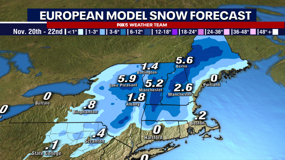
As far as winter weather is concerned, advisories are in place for the higher elevated areas of the Appalachian Mountains to our west. If you are getting an early start and traveling west Tuesday, be aware that some ice will be possible in these elevated zones (west of I-81) but that it should change over to rain quickly during the morning hours. For those traveling into the interior Northeast, this system put down the first widespread coating of snow in many locations. Those traveling to upstate New York or interior New England should expect some major delays as the storm leads to slick travel conditions in that region.
The good news is that the storm exits quickly on Wednesday, returning the D.C. region to sunshine – though it will be cool and breezy.
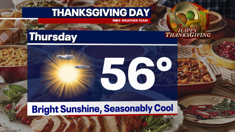
The Thanksgiving forecast on Thursday has been showing improvement, as weather models are now showing that it will not be as chilly as it was looking last week. We are now forecasting highs in the middle to upper 50s, which is about average for this time of year, but may make for the cooler Thanksgiving in recent years.
Here are D.C.’s temperatures on Thanksgiving over the last decade!
2022 - 61°
2021 - 59°
2020 – 67°
2019 - 54°
2018 - 42°
2017 - 47°
2016 - 57°
2015 - 64°
2014 - 49°
2013 - 40°