

SNOW FORECAST: Snow, sleet and rain expected Sunday into Monday across DC region

FOX 5 Weather forecast for Friday, January 14
Mike Thomas has the FOX 5 Weather forecast for Friday, January 14
WASHINGTON - It is becoming increasingly likely that parts of the region will be dealing with a significantly impactful winter storm during the second half of the upcoming Martin Luther King Jr. holiday weekend.
Overnight weather model guidance continued to trends towards the storm turning northwards up the East Coast as opposed to passing to our south out to sea.

FOX 5 Weather forecast for Wednesday, January 12
Tucker Barnes has the FOX 5 Weather forecast for Wednesday, January 12
While there is more agreement this morning that the storm will make an impact, the exact nature of that impact is still yet to be determined due to a number of factors. The devil is in the details with a storm like this, and the details will still need several more days to work out.
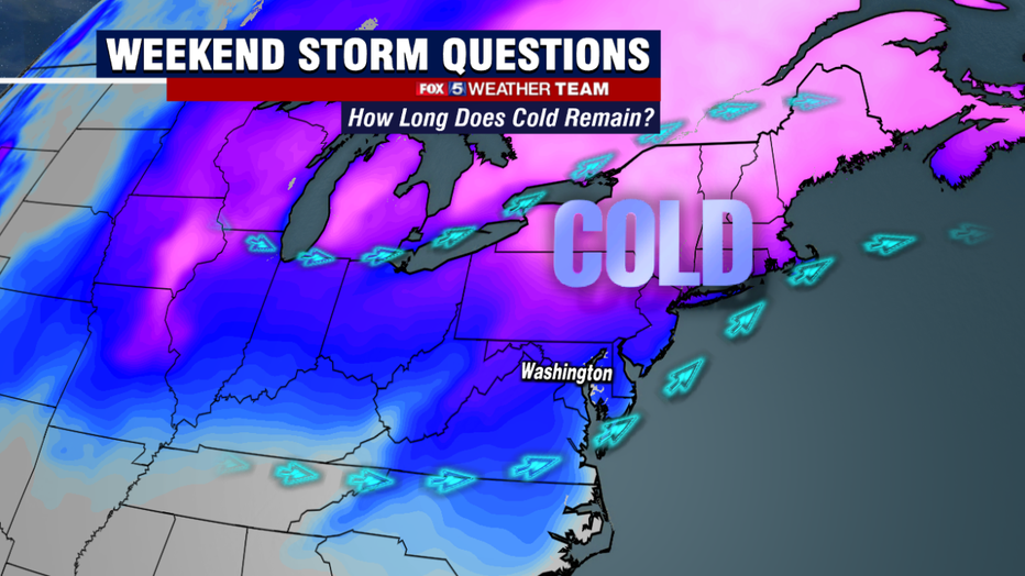
The one thing that does appear to be a certainty is just how much cold air will be around ahead of the storm. While Tuesday was the coldest day that DC has seen in about three years, Saturday could be even colder.
This cold air will start to exit throughout the day on Sunday, and then the race is on. The faster the moisture arrives during there day on Sunday, the more likely it is that the region sees a widespread snowfall as the system begins.
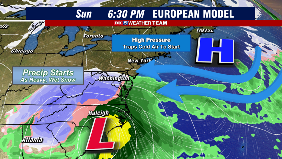
Examining some of this morning's guidance, the consensus as of today is that the precipitation starts pushing into the DC region sometime on Sunday afternoon. Enough cold air is likely to still be around, the in all likelihood this would start as snowfall for most of the region.
While the snow is coming down though, cold air would be on the retreat as high pressure, the feature responsible for bringing in the cold air on Saturday, starts to exit into the Atlantic.
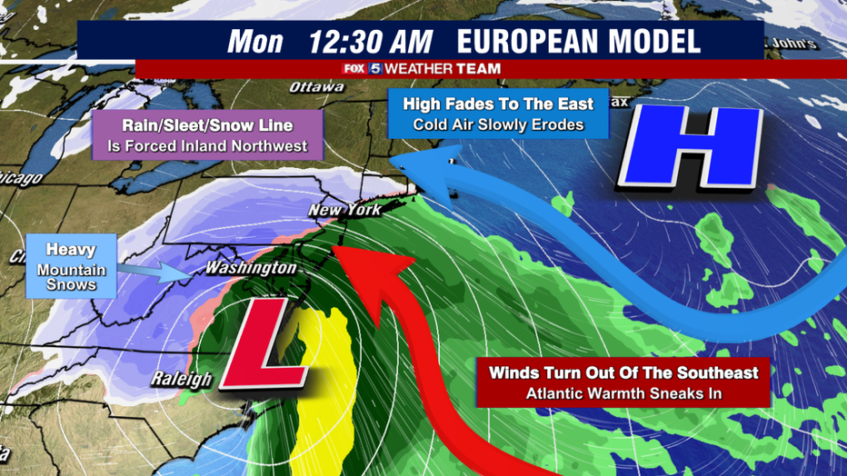
As the cold air exits, and the storm begins to intensify to our south, winds will start to turn out of the southeast. This starts to mix some milder, Atlantic moisture into our region, which would cause the snow to switch over to sleet, and potentially even a soaking rain depending on the exact track of the storm. Even with the storm pumping in the warmer air though, cold air can still become trapped near the surface and be slow to exit.
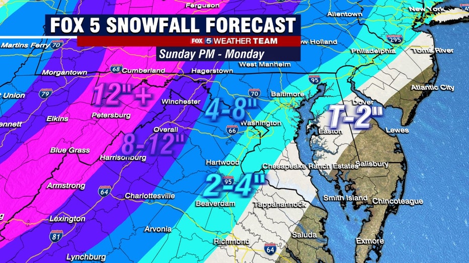
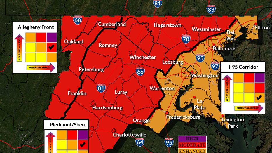
If this ends up being the case, there could be a prolonged period of sleet and freezing rain, both of which would cut back significantly on snowfall potential in our region. At the same time, this would not be the case for everyone. Some out to the west would likely see very heavy snows continue as ample moisture gets pumped into our region. The areas west of the I-81 would be at the greatest risk for the highest totals in such a scenario.
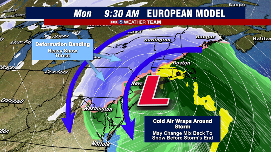
As the storm continues its journey northward and intensifies, it would eventually wrap back down some cold air from the north onto the backside of the storm. This could have the potential to change mix and rain back over to snow as the storm pulls away.
I will say, more times than not, this ends up not happening for the DC area as cold air usually fails to make it down this far south fast enough, but the potential would be there for some of our nothern zones to bring in some additional accumulation on the backside of this system, even if they at one point do turn over to rain.
So what kind of totals are we talking about here? Well one thing that seems certain if this storm comes up the coastline, is that it will not lack for moisture.
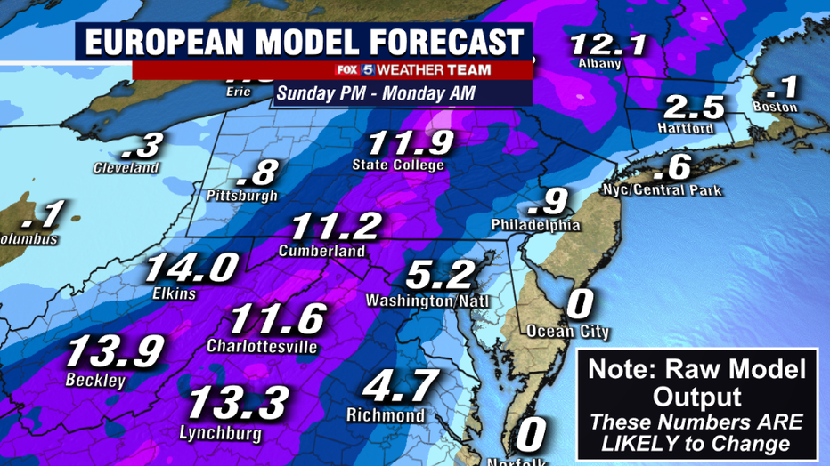
Both of the weather models today suggest that up to 2" of liquid would be possible out of this system. If that was all pure snow, that would suggest around 20 inches…but in all likelihood it will not be. However, this does make it more likely that someone in the Mid-Atlantic and Northeast will end up with a foot or more of snow when this is all said and done. It is determining where that is tricky.
This morning's guidance all suggested these highest totals would be found to the west of town. Both models do have DC picking up several inches of snow initially, before the change to rain. As mentioned at the beginning of this article, the devil in the details, and these details still need to be worked out in the days ahead.
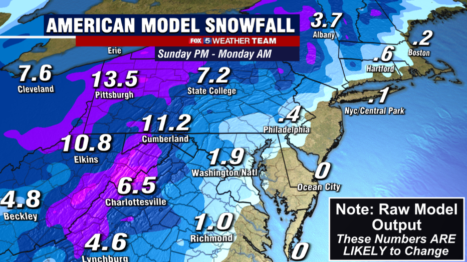
One of those "devilish details" is the exact track of the storm. The European model today was the farther to the east with the track of the storm, and thus the rain/storm line did not track as far inland to the northwest. By contrary, the American model was significantly farther west with the track of the storm, and that allowed warmer air to penetrate much farther inland.
This would lead to more mixing, even in northwest zones, with the highest totals being confined to the mountain regions. Which model will be correct? Only time will truly tell, but we will continue to monitor the data as it comes in to look for farther agreement. Expect updates throughout the remainder of the week.
Regardless of how much snow ends up falling, the storm is likely to have a very high impact on travel up and down the East Coast for the holiday weekend. Wind, snow, ice, and rain are all likely to cause pretty significant travel delays.
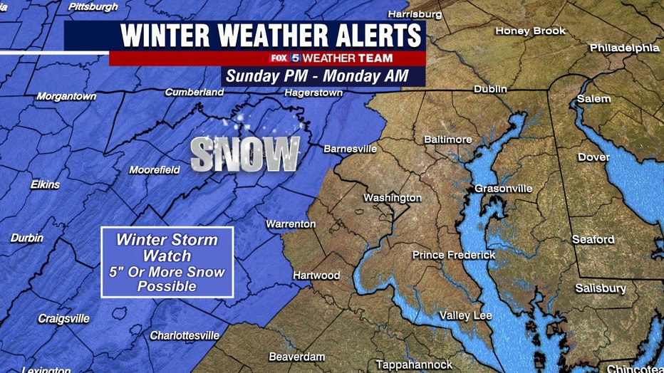
Confidence has increased enough that the National Weather Service placed most of our region in a moderate risk of a high impact winter storm event for the upcoming weekend. So make sure your checking back for the latest information on the weekend ahead, especially if you plan to travel.