

Multiple snow, ice threats for DC through mid-February
DC winter weather: More snow, ice, and freezing rain on the way
Upcoming winter weather threats include freezing rain Thursday, potential snow and ice Saturday, and a mixed weather event next Tuesday. FOX 5 meteorologist Mike Thomas has the latest forecast.
Just days ago, Punxsutawney Phil famously saw his shadow in eastern Pennsylvania, predicting that six more weeks of winter would grace our skies here in the eastern half of the United States.
At least in the short term, he does appear to be right.
When will DC's winter weather end?
While temperatures certainly are not forecast to be as cold as they were in January, there are still a number of opportunities for winter weather in the D.C. region over the next couple of weeks.
This has everything to do with where we find ourselves in the current pattern. Winter cold remains strong but focused primarily up in Canada.
At the same time, some early signs of spring are starting to make their presence felt in the southern states, where more frequent 70s and 80s have been so far this month.
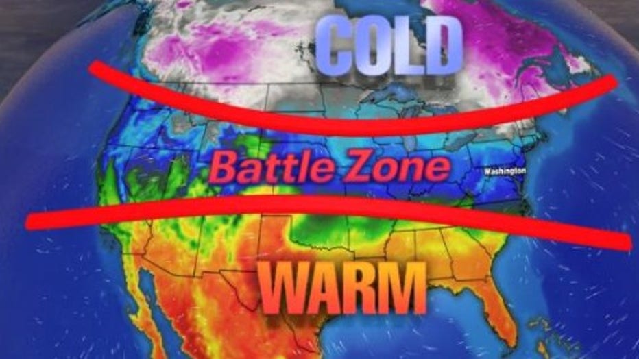
What is a baroclinic zone?
Caught in between is much of the Plains, Midwest, Mid-Atlantic, and Northeast in an area known as a baroclinic zone.
This is the area where there is a great change in temperature over a relatively short distance. They are zones of instability, and zones where storms often form. This is where we find ourselves here in D.C. and, indeed, there are several opportunities for stormy weather ahead.
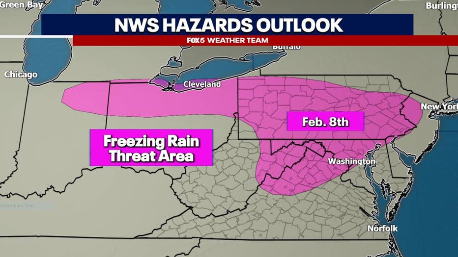
Threat One: Overnight - Thurs:
When we are in this type of pattern, what we get is a lot of back and forth. Milder days, replaced by colder days, but then, as cold air begins to leave, you tend to "attack" it with moisture-rich warmer air from the south.
This is the case overnight into Thursday morning.
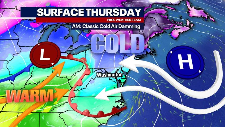
Cold air damming
Cold air is actually leaving our region, but due to the mountains to our west, and winds shifting out of the east, the cold gets almost "stuck" at the surface.
Referred to as cold air damming, this process traps a layer of drier, colder air (which is heavy) near the surface as warm air streams in overhead.
It is a classic recipe for sleet, freezing rain, and ice.
The strength, and most importantly, the atmospheric depth of the trapped cold air is what matters the most for events like this one. Freezing rain occurs when most of the layer is actually above freezing, but the air closest to the surface remains below freezing.
This causes it to appear that it is simply raining outside, but the rain freezes upon contact with a subfreezing surface. The ice it causes can be extremely dangerous to travelers, and can lead to downed trees and subsequent powerlines.
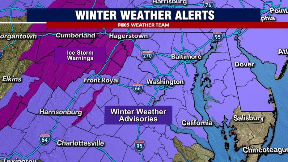
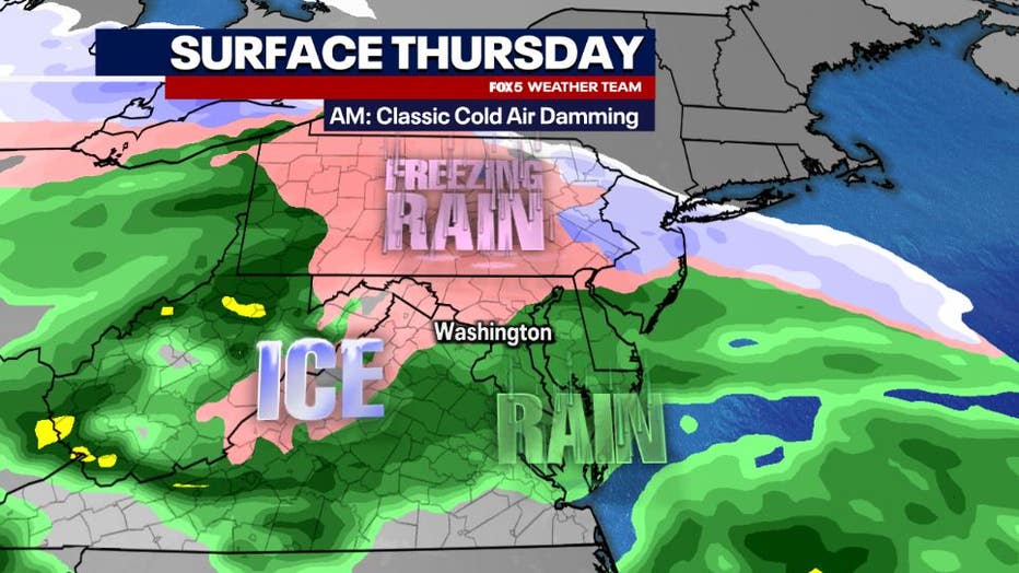
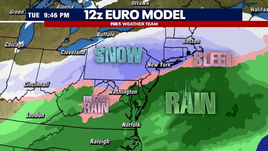
Winter weather advisories, freezing rain in DC region
Most models Wednesday night are suggesting what is pretty typical for freezing rain events in the DC region — the risk is going to be greatest northwest of the immediate D.C. area.
While winter weather advisories were expanded today to include much of Southern Maryland and the Eastern Shore, recent guidance suggests the threat for icing in that region is more isolated, as most of the area may hover just above freezing. Far northwestern zones, where Ice Storm Warnings have been issued, are more likely to see more significant icing impacts.
Still, a number of school districts have decided to at least issue school delays tomorrow in the hopes of getting past the worst of the icing concerns.
The system is also a very fast mover.
Most models suggest that moisture moves out quickly by the middle to late morning hours.
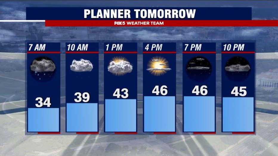
DC weather forecast
Some sunshine is even possible by the time we get to the afternoon, allowing temperatures to rebound into the 40s and 50s across much of the D.C. region. Any impacts from the morning ice event should not linger past midday.
The evening commute Thursday should be just fine.
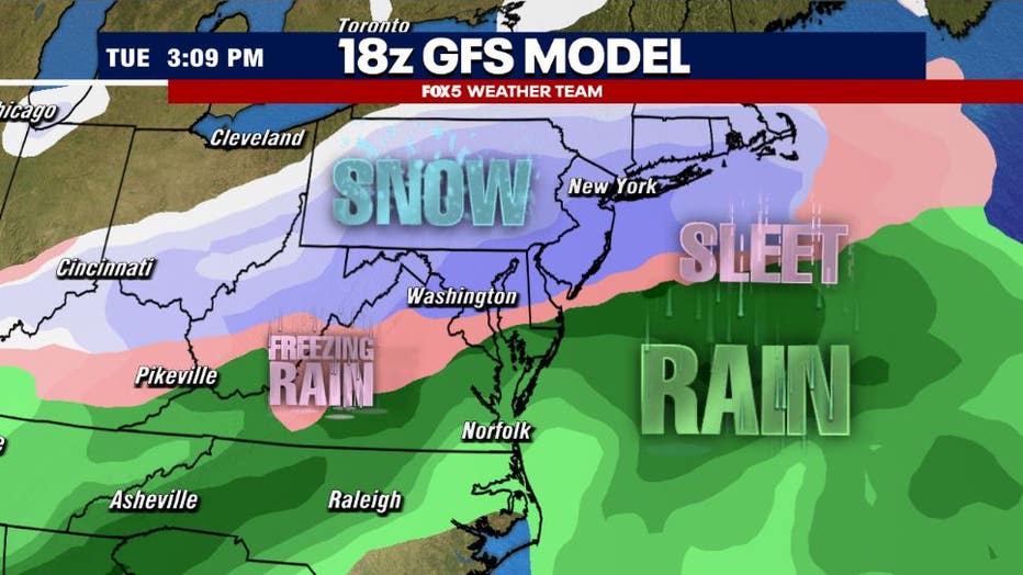
Threat Two: Saturday:
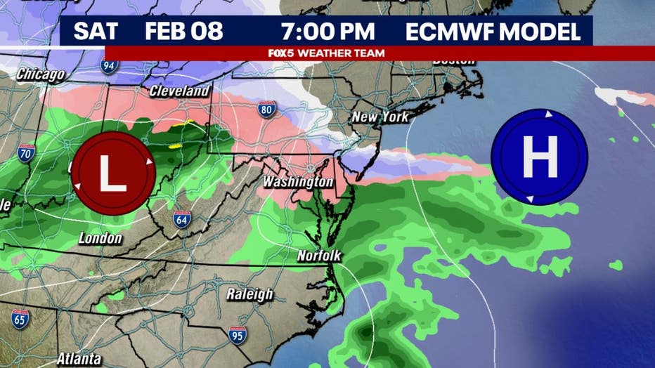
Saturday brings a very similar threat as Thursday morning does, though the timing is different. The setup is very similar.
Potential snow, sleet Saturday across DC region
Cold air is entrenched across the Mid-Atlantic with high pressure overhead on Saturday morning.
By Saturday afternoon, this high starts pushing off the Northeast coastline as a wave of low pressure builds in from the west in its wake.
Unlike Thursday evening, which is mostly a pre-dawn concern, this system may start moving into D.C. later in the day on Saturday.
There is the potential that initially the depth of the cold pool could be strong enough that the event could start as a period of snow, before going over to sleet and freezing rain later in the evening.
As the system quickly gets to our north, temperatures are likely to warm into the overnight hours into the early morning hours on Sunday, when a few lingering rain showers are possible.
Clearing is then expected for the remainder of the day.
The primary impact of Saturday's system will be felt by those with evening plans for Saturday night. Impacts are not expected to linger into Sunday.
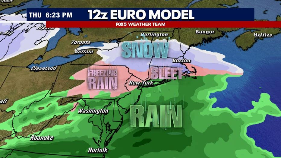
Threat Three: Next Tuesday:
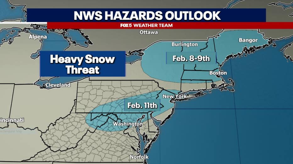
Looking even further ahead, there is a lot of buzz on social media about the potential for more winter weather next week.
I have seen a lot of high snowfall maps being tossed around social media, and even the National Weather Service has parts of our region highlighted in a zone of "heavy snow potential." I would be rather cautious getting caught up in snowfall totals this far out from a winter weather event.
Much like the pervious two systems, this one very much has the potential to deal with some mixed issues.
While weather models over the last several days have been pretty consistent with showing shoveable snowfall event in D.C., several weather models have started to suggest on Wednesday that cold air may not hold strong enough for a pure snow event in the immediate D.C. area.
What is an overrunning snow event?
This event looks to be what forecasters call an overrunning snow event.
Similar to what happened here back in January, this is an event where warm air moves over a deeper cold layer, causing snowfall.
If that sounds similar to what causes freezing rain in D.C., it is! The difference is simply that the cold air is much deeper in the atmosphere, or rather, the warmer air moving in is initially very shallow.
This can allow an event like this one to start as primarily snowfall, and the potential for a heavy one at that.
Several inches could quickly pile up on the front end of the system. However, as the cold air weakens and the warmth continues to stream in, these very often lead to transition events, where snow changes to sleet, freezing rain, and eventually rain.
This can significantly cut back on forecast snowfall totals.
This is the primary concern I have with the system on Tuesday, that it is not just a pure snowfall event.
Of course, there are models that disagree.
The American model for example, has a much stronger and more stubborn cold pool holding place from D.C. to the north, keeping the event as primarily snowfall for the city.
This would end up being similar to the January event if it happens, and a winter storm level snow would not be out of the question. This event is still just under a week away though, so we have several days yet to watch to see how cold air will play out across our region next week.
That will be the key in whether or not we are shoveling, or dusting off the umbrella.
More Threats: Next Week ...:
How much snow fell in D.C. in January?
Regardless of what happens in the short term, there is no denying that this is a very active pattern for our region.
While January did bring the D.C. region over 8" of snowfall, it was a pretty dry pattern otherwise.
In fact, the month finished nearly an inch below normal in terms of precipitation.
Much of the region remains in a moderate to severe drought. The next two weeks we will try our best to make up for January's rain shortfalls.
Another system looks likely during the latter half of the workweek, though confidence is very low at this time whether there will be enough cold air around to make this anything other than a rain event here in D.C.
Models suggest another threat towards Presidents' Day weekend, however, and potentially more right into the second half of the month.
It's an active pattern, and we will continue to monitor and keep you up to speed as we make our way through the last month of meteorological winter.
The Source: The information in this report comes from the FOX 5 DC Weather Team.