

More snow Friday in DC area likely to cause delays, closures

Friday snowfall forecast: DC area braces for potential delays and closures
FOX 5 meteorologist Mike Thomas delivers the latest forecast so you can be prepared for the snow on Friday.
BETHESDA, Md. (FOX 5 DC) - After the snowiest day in two years on Martin Luther King, Jr Day Monday, our region looks likely to close out the shortened workweek with a little more snow. Here we go again!
While there is still some debate as to exactly how much snow will fall, the timing of that snow is likely going to make the morning hours around our region extra tricky on Friday.
Let’s dive into what we know as of Wednesday evening.
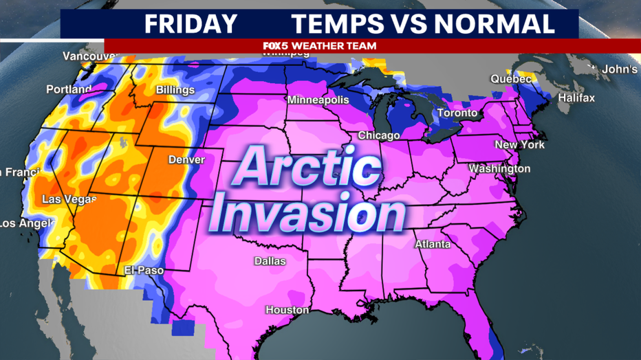
Just like the Monday event, the cold plays a major role in just how impactful even a light snow can be.
Washington, D.C. woke up to a temperature of 16° Wednesday morning, their coldest morning since last February.
Dulles Airport in Virginia saw temperatures dive into the single digits. It was 8°F on Wednesday morning – the coldest morning at the airport since Christmas Day of 2022.

DC, Maryland, Virginia prepping for second round of snow Friday
The DMV is getting ready for a second round of snow on Friday. FOX 5's Nana-Sentuo Bonsu spoke to officials in Virginia about prepping the roadways.
This is true Arctic air, called such because it originated up over the polar regions of northern Canada, which has made this the coldest week of winter so far.
The ground is plenty cold. The point?
Friday will be another case of every snowflake, whether light or heavy, will stick.
The question then simply becomes, how much will fall?

READ MORE: DMV Winter 2023-2024 Outlook: Why we're expecting more snow, chance for blizzards in DC this winter
READ MORE: How much snow fell? Totals for DC, Maryland, and Virginia
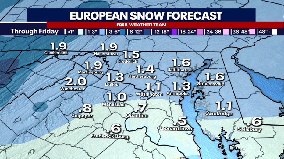
How much snow will the DC area get on Friday?

This is another case where it is not an easy call.
We are not dealing with a particularly strong surface system here. We are essentially dealing with a wave of upper atmospheric energy, what forecasters refer to as a shortwave, crossing over the Northeast and Mid-Atlantic on Friday.
This feature will drag some southern moisture northward and throw moisture on top of the cold air in place overhead. The exact track and strength of this feature are key to how much snow can fall in our region.
At the moment, we are favoring 1-3" of snow for those north of I-66 in Virginia, while those to the north of I-70 in Maryland could see some of the heavier 2-4" totals.
The mountains to the west, particularly westward-facing slopes, will see the highest amounts from this storm, and indeed, winter storm watches have already been issued for that region ahead of the storm.
For those on the eastern flank of the mountains, we do worry about a stronger fall line in snow totals compared to Monday’s event.
This is because this system is a little flatter, and is more west-east in direction when compared to Monday’s system.
The tricky part is, though, the energy of this system is greater on Monday. So will the two balance out?
This is something we will be watching closely in the next 24 hours.
What time will the snow start in DC on Friday?

Snow day fun in the DMV: Kids, parents bring out their sleds
Many school systems in the Washington, D.C., Maryland and Virginia regions were closed Tuesday after the D.C. area saw its first significant snowfall in years. FOX 5's David Kaplan was in Bethesda where the kids and parents were having fun on their sleds.
One thing we are confident about with this event is that it will impact Friday morning.
Many weather models bring the snow in right around or even a couple of hours before sunrise on Friday.
Given temperatures are naturally at their coldest before sunrise, the ground temperatures will be very cold, and it will not take long at all for snow to start sticking — especially on untreated surfaces.
With much of the region still covered in ice and snow from Monday’s event, this will likely only compound issues.
Friday’s commute could be an absolute mess.
Forget the amounts for a moment. Just given the timing of the snow event, there are likely to be widespread delays, if not cancelations around the region, unless something drastically changes before Friday.
Prepare for this possibility ahead of time!
The snow should wind down into the middle to late afternoon hours, tapering off to snow showers by the evening hours.
Bust Scenario:
In the forecasting world, a "bust" is what is called when a weather event significantly underperforms an expected outcome.
Much like Monday, this is another case where precipitation type is not in question. This will be a snow event.
The issue lies in exactly how much moisture will get pulled into the region, and how heavy it could be.
Several weather models, like the often-cited American and European models, suggest that snowfall will be very light.
I would say a bust for this event would be if most of the region east of I-81 and south of the Mason-Dixon line picks up less than an inch of snow.
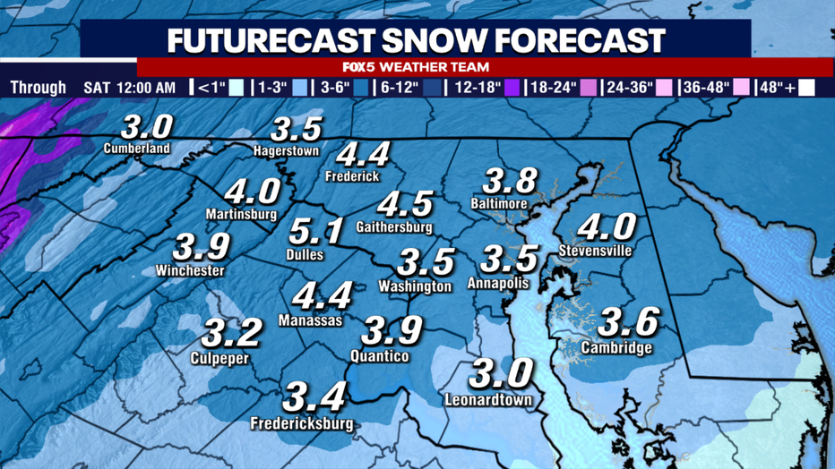
Boom Scenario:
The opposite of a bust scenario is, of course, the boom scenario, which is where much of the area picks up more snow than expected.
I would argue that this was indeed the case on Monday.
We were expecting 1-3" in D.C., but most of the area got 3-4" or more instead.
There are a couple of weather models that are suggesting that this could be the case once again. Whether or not this will come true will be heavily dependent on the exact track of the atmospheric energy relative to the D.C. region, but there are at least some models suggesting that it is a possibility.
This is still an El Niño winter, and storms during these types of winters tend to be a little more moisture-heavy than light. It will be a risk we monitor over the next 24 hours.
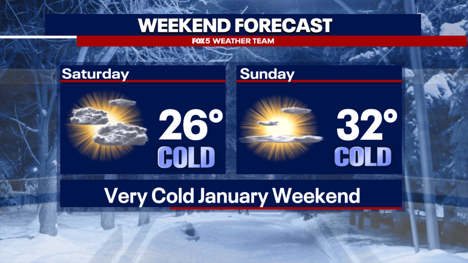
Regardless of how much snow we get, another guarantee we have is that the weekend will be extremely cold.
Saturday in particular, where temperatures are currently forecast to be their coldest since Christmas Eve of 2022 (D.C. had a high of 22°) and wind chills may not get out of the teens.
It will at least be a dry weekend, however, allowing our region to clean up from any of the snow leftover from Friday.
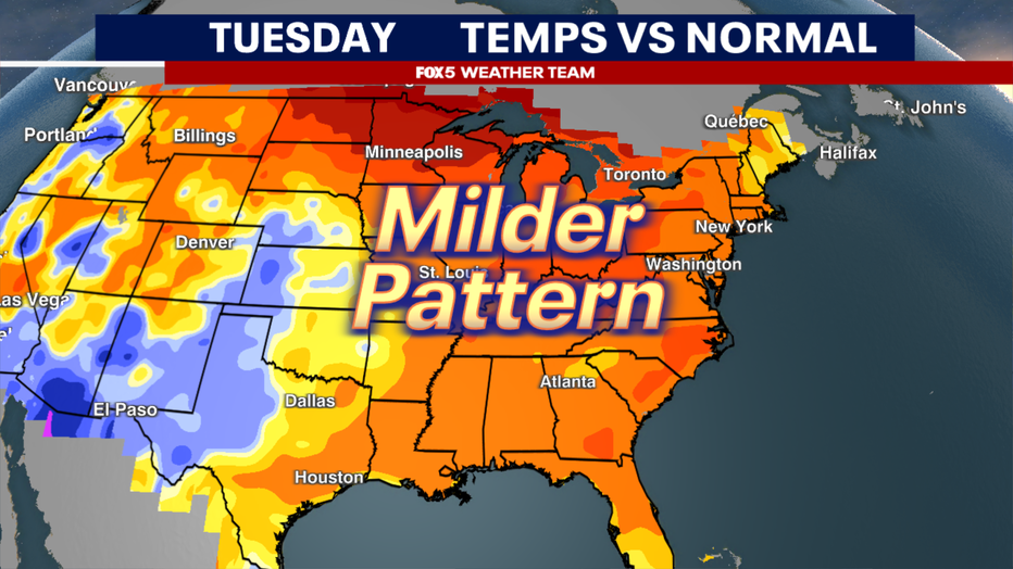
For those already over the cold and snow that January has brought us so far, I do have some good news for you.

DMV Winter 2023-2024 Outlook: Why we're expecting more snow, chance for blizzards in DC this winter
With a potentially strong El Niño in play for the 2023-2024 winter season, we're forecasting more snow than an average winter for the Washington D.C. metro, Northern Virginia and Maryland.
As we look beyond the weekend, this brutal cold that has overtaken much of the country will finally begin to soften.
By the middle of the week, high temperatures should return to average values (middle 40s) while early suggestions are that the upper 50s and perhaps even some 60s will be possible by the end of next week.
Does this mean we are done with winter? Not likely.
El Niño winters average over half a foot of snow in February.
Of the 27 cases of El Niño winters that we have here in D.C., only six cases have ever come with no measurable snow at all in February.
Long-range models do show some stronger winter cold returning to the D.C. region during the first couple weeks of February. Perhaps, some larger snows will come with them as well.
The FOX 5 Weather Team will be with you through them all!
When news breaks, stream FOX 5 DC anytime. Get the FOX Local app on your smart TV.