

Bulk of midweek snowstorm likely to miss DC: timing, impact, and what to expect

DC snow forecast: Bulk of winter storm to miss DC region
The bulk of a midweek storm that is moving toward the East Coast will likely miss the Washington, D.C. region and head out to sea.
WASHINGTON - UPDATE 8AM MONDAY: The bulk of a midweek storm moving toward the East Coast will likely miss the Washington, D.C., region and head out to sea. "The bulk of the energy here and the bulk of our storm, rather than sliding up the coast and giving the big cities a good snow, will kind of scoot out to sea here, off to our south and east," said FOX 5 Tucker Barnes.
GET THE LATEST FORECAST: https://tinyurl.com/27vwpd3d
A previous version of the story appears below:

DC snow threat: Are we talking blizzard?
You may have seen the buzz on social media, and yes, it’s true—there’s a strong chance of another significant snowstorm in the D.C. region next week. FOX 5 meteorologist Mike Thomas has all the details.
UPDATE 5 p.m. Sunday:
Weather model trends over the past 24 hours have turned towards a more progressive scenario with a midweek snowstorm in D.C.
This would mean the "slider" solution (detailed below) is more likely at this point. In this case we'd be talking about a lower impact storm with less snow, and a full on blizzard is likely off the table. However, we are still expecting snow in the metro from Wednesday afternoon through Thursday morning.
On Sunday evening, the models are generally showing six inches or fewer in the D.C. metro area with a harder hit down south, from southeastern Virginia through the lower Eastern Shore.
Updated forecast totals from the morning runs of the European model and American model are shown here.
An important thing to note is that this storm could still change, the higher snow totals could shift northward and be back over us. It is hard to imagine though that the historic, classic Nor'easter solution will reappear.
We are still 72 hours out from the storm, and therefore adjustments will likely be made.
When will it snow in DC this week?
The timeframe to watch is Wednesday afternoon through Thursday. But the big question remains: how much snow will we get?
That question is a little more difficult to answer at this stage, but we will do our best here to give you an idea of what some possible outcomes could be.
Will D.C. Get Snow? Here’s What We Know
As of Saturday night, I see two scenarios for this midweek snowfall here in D.C. Now, if your primary question is will we get snow at all? Then I have to say, I would say I have a 90-95% likelihood that, yes, snow will fall.
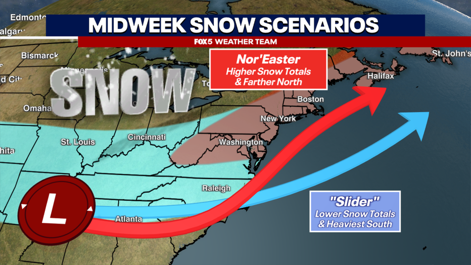
Where the uncertainty comes is in the amount of snow that we get, which is heavily dependent on the strength and location of the surface low-pressure system along the coastline. Unlike the last two storms we have dealt with in D.C. this winter, this one is the first that has true nor’easter potential with it, and therefore the "highest ceiling" when it comes to possible amounts.
And that leads us to our two scenarios. The first is a classic nor’easter. The storm hugs the coastline, rapidly intensifying, and throws back a lot of snow across the I-95 corridor — amounts that D.C. has not seen in the better part of a decade. Widespread areas exceeding a foot of snow from Richmond to Boston would be possible with such a storm, with snowfall amounts that we would likely talk about for years to come. This scenario is on the table for this particular storm.
Another scenario, one that I would give equal odds to as I sit here tonight, is what I call a "slider." This is where the storm passes to our south and takes a stronger curve to the east as it is pulled northward. This would keep the heaviest snow farther to our south and east, similar to what we have already seen happen several times this winter. Now, I want to be clear that in such a case, we would still get a solid snowfall for the D.C. region, just not one for the history books.
So, why are these two scenarios on the table today? And what does each look like? Let's break it down.
Scenario 1: The ‘slider’
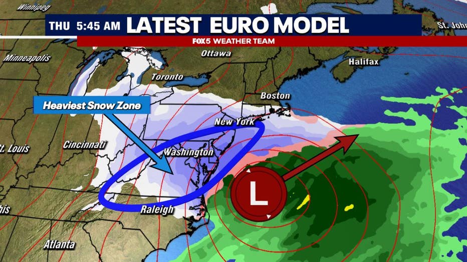
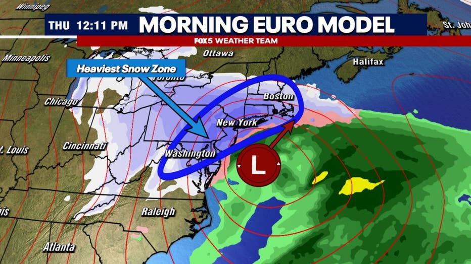
In a "slider" scenario, the wave of low pressure passes to the south of the Mid-Atlantic. It is still intensifying as it pushes off the coastline, throwing back heavy snow into parts of the Mid-Atlantic, but it takes a much more "rounded" turn to the northeast. As such, it gets farther off the coastline, faster. Giving less time for the heaviest bands to impact part of the D.C. region. As such, the heaviest snowfall is typically found to the south & east of the I-95 corridor. The most recent run of the European model, shown above, shows this.
What’s driving this storm?
So what’s driving this? The key to this entire event is going to be a wave of upper level low pressure over the Great Lakes & Midwest. Much of today’s weather model guidance on this feature was flatter and weaker. This is important because it is this feature which "captures" the storm when it is off the Mid-Atlantic coastline. If it’s stronger, the storm takes a more northerly track and hugs the coastline. If it is weaker and flatter, as the model above shows, the storm is pushed farther out to the east, and heavy snow is not as expansive.
By the numbers:
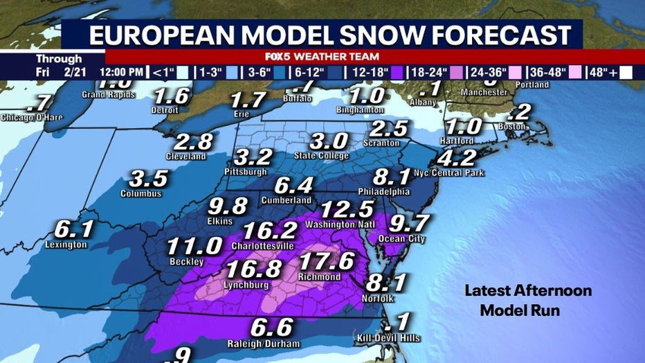
And you can see this reflected in the forecast totals out of the model at the surface. Note first, that this is raw data, and these numbers are guaranteed to change (as you’ll see they already have later in the article) in the days ahead. But also note that it is still showing a solid snowstorm for the DC area, but note where totals are highest…south and east. That is the "slider" scenario. Totals could go up or down depending on the strength of the surface low, which we need to continue to watch in the days ahead.
Scenario 2: A classic Nor’easter
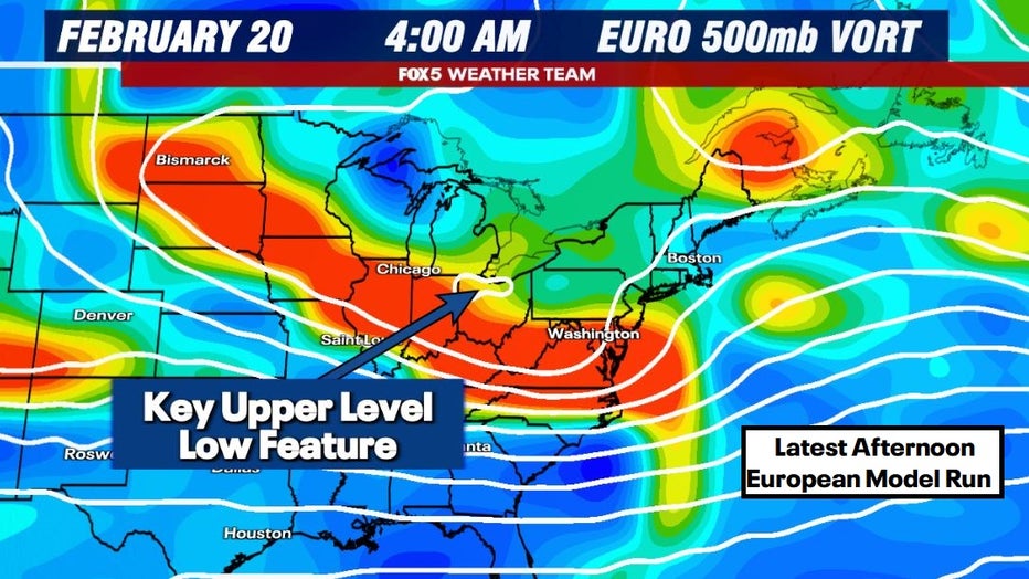
To give you an idea of how much things can change in weather, let's do something a little different. Let's take the exact same weather model. The European model is a favorite among weather forecasters, but let's go back just one model cycle, to the morning run of the European, known as the 0z run.
This run showed a classic nor’easter – a strong and rapidly strengthening storm just off the Mid-Atlantic coastline pushing up towards Cape Cod, MA.
Heavy snow blanketing the I-95 corridor as strong banding develops on the northwestern flank of the low. For at least the D.C. area, this model shows an (on average) once or twice a decade type snowfall event.
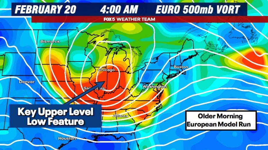
Now look at the upper levels. Keep in mind this is for the same time, same storm, same weather forecast model as we showed up above. It is just simply one model cycle different. Rather stark difference in the upper levels, right? You have a clear and strong cutoff low, dipping southward through the Midwest. It is this feature that is causing the storm to both rapidly intensify and hug the coastline. Changes to this feature are what are causing the differences in the storm at the surface.
What does this mean for snow?
By the numbers:

And that is clearly reflected in the forecast snowfall totals. As you can see above, this scenario would have widespread 1-2 feet totals from Richmond to Boston.
A classic Mid-Atlantic and Northeast blizzard, but that is only if the upper low over the Midwest cooperates. If that upper feature ends up coming in flatter and weaker, which the latest model runs have hinted at, you will not get a blizzard.
So those are the two scenarios I see at this stage.
Yes, there is the threat of some big snowfall totals next week. However, it would be foolish to suggest that a much more manageable, albeit still disruptive, snowfall scenario could not end up coming to fruition.
Stay with the FOX 5 Weather Team for the latest forecast updates as this active winter pattern continues for our region. The FOX LOCAL app is your source for live FOX 5 DC weather updates. Click here to download.
The Source: FOX 5 Weather Team