Light snow to dust DC Friday night, Winter Weather Warnings issued in Virginia
FOX 5 Weather Team Snowfall Forecast For Friday Night into Saturday for the DC region.
Another snowstorm headed toward DC region?
Cold air has allowed for very little melting across the D.C. region since Monday's snowfall.
Reagan National Airport still reported a snow depth of over 4" on Thursday evening, after picking up 7.2" during Monday's winter storm, the largest in over half a decade here in Washington.
Weather models have quickly moved away from the potential of a repeat or even bigger storm system to bring in the weekend here in the D.C. region, but that does not mean we get out of the system completely unscathed.
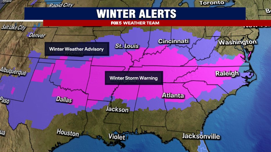
Winter Alerts Expand Across the North American South and Southeast ahead of a winter storm impacting the region.
Winter Storm Warnings from Texas to Virginia
As of Thursday night, winter storm warnings stretched from north Texas to the lower Eastern Shore of Virginia.
The city of Richmond, Virginia is also under a winter storm watch with the local National Weather Service office warning of the potential for the city to see 2-4" of snow. By comparison, the city picked up 3.5" of snow on Sunday night into Monday, but did mix with sleet, which impacted their snowfall totals earlier in the week.
There were not yet any watches or warnings for the D.C. area, and the FOX 5 Weather Team expects that the impacts are unlikely to get to winter weather advisory level for much of the area, with southeastern areas having the best chance for alerts.
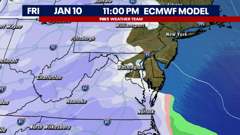
The European Weather Forecast Model, showing snow moving into the DC region after 10pm Friday night.
What time will snow start falling Friday?
After a pretty cloudy and once again cold Friday afternoon, light snow is expected to start overspreading the region into the later evening hours.
Snow is possible anytime after 8 p.m. in the far southwestern portions of the D.C. area, approaching D.C. sometime between 10 p.m. and midnight.
Unlike the last event which featured a wide swath of snowfall, it is likely that the snow field will be disrupted by the mountains to the west of town. The air is expected to be very dry over the D.C. region, as the center of this storm will be passing so far to our south.
It may take some time for the first flakes to actually reach the ground as some will undoubtedly be lost to evaporation.
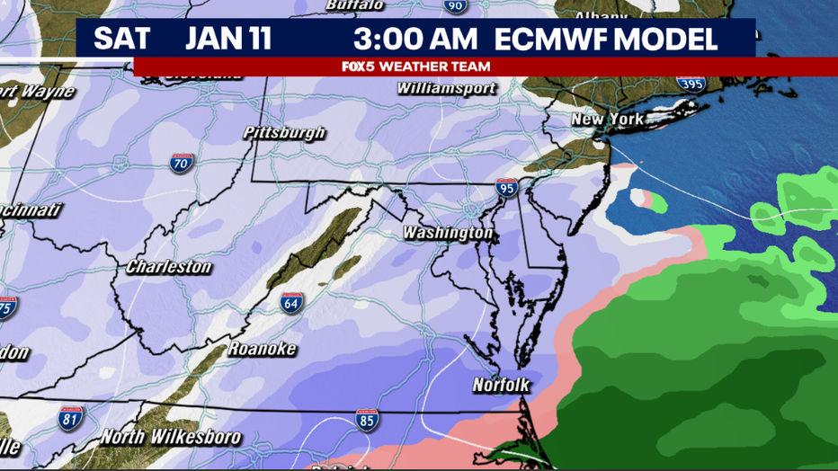
The European Model showing snowfall across the region in the hours before dawn on Saturday morning.
The snow is expected to be most widespread during the overnight hours.
The parent surface low with this storm system is passing far to the south, closer to the Outer Banks of North Carolina. If you want to be closer to the storm (just to the northwest of it) for heavier precipitation, the areas that are expected to see the most out of this particular system are closer to the Richmond, Virginia area, and through central, southern, and eastern Virginia where those winter storm warnings are already in place.
How much snow will fall in DC?
Around the D.C. area, as the storm strengthens, some light to moderate bands could develop closer to our region, though they are most favored southeast of the city.
The potential for an inch or two is present here, though we are not expecting snowfall rates nearly as heavy as what the region saw on Monday. North of town, I expect that the snowfield will likely be a lot more scattered with dry air intrusion.
Some north of D.C. will not see any snow at all.

The European Model showing snowfall exiting the DC region on Saturday morning.
Because the storm will not be turning to the north after passing through North Carolina, the system will exit our region relatively quickly on Saturday morning.
What is a shortwave?
The upper-level energy responsible for steering the storm, known as a shortwave, will pass over our region on Saturday morning. Enough upward motion is expected with this feature that some scattered snow showers and flurries will linger through the morning hours of Saturday, but by the afternoon, the snow should be all over in the D.C. region.
Some sunshine may even sprinkle in the second half of the day, ahead of a sunnier, dry Sunday.
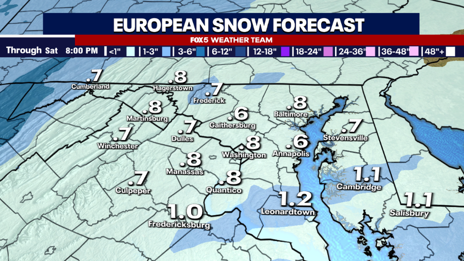
Raw data output from the European Weather Forecast Model, showing less than an inch for most of the DC region.
As mentioned above, this is expected to be a lighter snow in the D.C. region.
The most aggressive modeling we have tonight suggests that, at worst, 2-3" is possible in D.C., and 3-5" is possible in Southern Maryland, but these are "worst case" or so-called "boom" scenarios that are less likely to come true.
This far north of the storm there is a lot of dry air in place, and with the cold temperatures this is likely to be a finer snow than what parts of the region saw on Monday. There should be much finer flakes that will be easy to dust off when you awaken on Saturday morning.
All things considered, we expect this will be a minor impact event that is not terribly disruptive for the D.C. region.
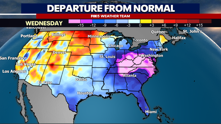
The forecast continues to favor strong cold well into next week.
Below freezing temperatures in DC next week
Beyond the weekend, the cold weather shows no signs of letting up through next week.
This looks most extreme during the middle of next week, when temperatures may struggle to make it out of the 20s for much of our region.
Some early week snow flurries courtesy of the Great Lakes do look possible, but the chance of accumulating snow looks low through most of the next workweek. Just keep the extra layers handy as the D.C. region continues to deal with its coldest start to January since 2018.
Toward the end of next week, changes in the pattern are expected to start to occur.
Upper atmospheric features closer to the polar regions have been driving the strong cold across the eastern half of the country. Anytime these patterns start to shift, you do have to be on guard for a storm to fire as the atmosphere "adjusts" to the shifting pattern.
This looks likely to happen around the timeframe of next weekend. However, I will caution that the word "storm" does not necessarily mean "snow." While we will be coming out of a cold pattern, the timing of when this happens for the next potential system is critical. Storms as a cold pattern breaking down can bring winter weather to D.C., but they can just as easily pass west of the D.C. region and bring the area plain old rainfall.
Timing all of these components is something the FOX 5 Weather Team will be watching closely over the next week.
The Source: FOX

