

Hurricane Helene Tracker: After landfall in Florida, could storm remnants impact DC region?
Tracking Hurricane Helene
FOX 5' meteorologist Mike Thomas has the latest details on Hurricane Helene and its impact on the D.C. region.
WASHINGTON - Fast-moving Hurricane Helene is advancing across the Gulf of Mexico toward Florida, and it's been upgraded to a Category 2 storm. Hurricane warnings have been extended for much of the western Florida coastline near Florida’s Big Bend. Ahead of the storm, Florida has issued a state of emergency and evacuation orders for much of the zone expected to be the hardest hit.
READ MORE: Hurricane Helene forces closures at national parks across the Southeast
Earlier Wednesday evening, the National Hurricane Center increased their forecast projections for Helene, now predicting it will rapidly intensify into a powerful Category 4 hurricane at landfall, with winds exceeding 130 mph.
Some model guidance suggests the storm could be even stronger. The most powerful weather model for hurricanes, the Hurricane Weather Research and Forecast system (HWRF), indicates Helene may approach Category 5 strength with winds exceeding 150 mph ahead of landfall on Thursday night. Life-threatening storm surge and flooding rainfall are expected. Helene will be a devastating storm.
After making landfall on Thursday, Helene will push inland towards Atlanta while quickly weakening. Heavy rains will spread throughout the Southeast. Parts of Georgia could see over a foot of rain as the storm lifts northward before shifting west.
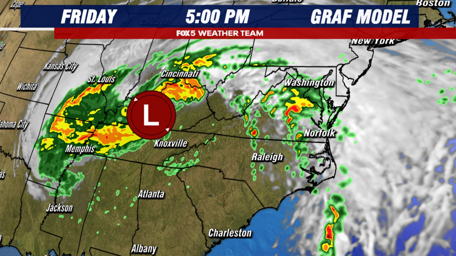
As the storm weakens, the associated precipitation field will expand northward into the Midwest and Mid-Atlantic states on Friday. Here it will clash with drier air at the surface, present over the Great Lakes and Northeast, causing the precipitation field to weaken.
Despite being more powerful than Debby at landfall, Helene is not expected to bring similar rainfall to the Washington, D.C. region due to its track. The area can expect some tropical downpours on Friday, with less than an inch of rain in the immediate D.C. area and 1-2 inches possible to the southwest.
READ MORE: Hurricane Helene: Maryland, Virginia rescue teams deployed to Florida ahead of storm

Helene will turn dramatically west due to a cutoff low, an upper-level low-pressure system stuck across the southern United States, separated from the jet stream in Canada. This feature will "catch" Helene’s remnant low, stalling it over the southern Midwest through the weekend. Unfortunately, this will impact the D.C. region’s forecast.
As long as this feature remains, the D.C. region will experience gloomy weather with clouds, drizzle, and showers. Initially, it seemed this would clear by the weekend, bringing sunshine. However, the cutoff low is moving slower than expected, so showers are possible on both Saturday and especially Sunday as Helene’s remnant low passes near the region.
This gloomy pattern could persist into the first half of next week until a shift in the jet stream finally moves the cutoff low out of the region by midweek.
