First snow of 2020 to impact Tuesday afternoon commute
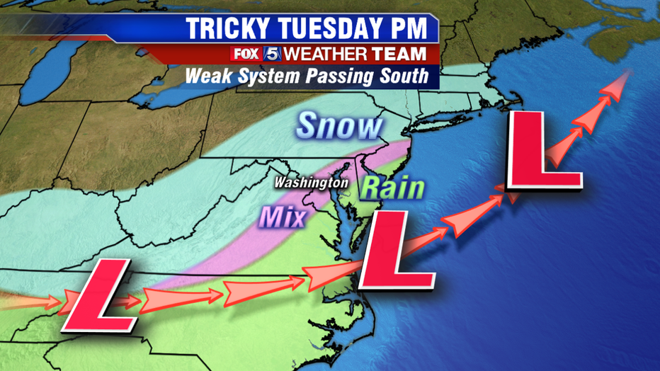
WASHINGTON (FOX 5 DC) - The holiday season has come and gone, thankfully without much winter weather concerns here in the Washington, D.C. region. As most get back to work and school on this first Monday of 2020, the quiet weather continues. Monday afternoon should feature sunshine with highs near 50 degrees downtown, not bad at all for a January day! Tuesday will bring that streak to an end though, as a storm system passing to our south should pull down enough cold air to change rain over to snow for a period of time tomorrow afternoon even within the Beltway. A Winter Weather Advisory will go into effect for parts of the region from noon to 7 p.m.
Download the FOX 5 Weather App

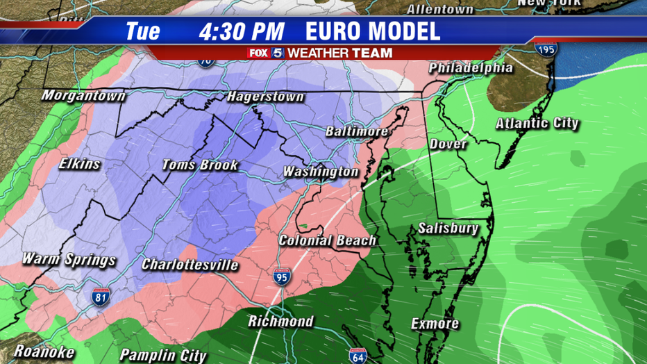
One key difference between this system and the winter events we saw during the month of December is in the timing. Every December snow event we had to contend with affected the morning commute across the region. This time around, we anticipate the morning commute being dry. With temperatures expected to reach the lower 40s, as the system approaches our region between 11am-2pm it should start to overspread the I-95 corridor with rain first. However, enough cold air will be present above the surface that as the rain picks up in intensity, we should start to mix with a period of sleet and then eventually change over to all snow by the middle to late afternoon for the metro area. Those north and west will make this transition faster, while those south and east will do so slower, and in some cases far enough south and east will not change over at all.

Once we do make that change over, the battle becomes a classic one when it comes to how much snow is able to stick. Can we snow at a heavy enough rate to accumulate snow faster than the ground can melt it? Consider this. Washington, D.C. has only hit the freezing mark once since December 26th. Ground temperatures are by no means warm, but they are not as cold as they could be at this time of year. Light snow would melt on contact, you need a moderate snowfall to cause issues. Now, some of our latest guidance does say that yes, there is going to be a period of time sometime between 3-6pm when models are saying some of the heaviest precipitation could be. Another key detail with this system that will affect the totals is how fast it will move. This is no winter storm, no blizzard. By 6-7pm the storm system should start to exit the region, and skies should even clear by the late evening hours.

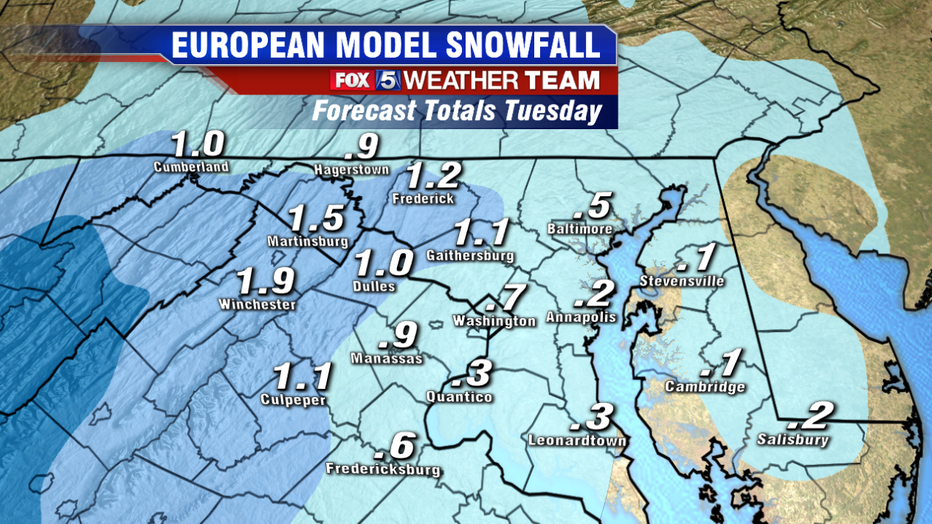
Similar to the snow events in December, we are not talking about a lot of snow outside of the mountain areas. Assuming that the guidance is correct and we do get a couple of hours of steadier snowfalls in and around the region, we could accumulate an inch or two of snow in some places. Northwest areas like upper Montgomery, western Howard, Frederick and Carroll counties in Maryland and western Loudoun and western Fauquier counties in Virginia will have the best shot at some of these amounts. Closer to the I-95 the slower transition over to snow should help keep snow totals below an inch in most locations.
The biggest issue would be the timing, as current guidance suggest we may make that transition during the front end of the evening commute. As we all know, it does not take much snow at all to cause problems on the roadways. The fact it will likely start as some rain will make treating the roads ahead of time tricky as well. So plan ahead on the evening commute tomorrow potentially being a bit of a rough one. Watch out for slick spots around and just after sunset, particularly on lesser traveled side roads and side streets. With the light amounts however, we do not anticipate any issues lingering into the Wednesday morning commute.
For those that are not big fans of the cold or snow, how about we wrap things up on a good note. We have 60s in the forecast again before the end of the week!
Stay tuned to Fox 5 and check out the free Fox 5 News & Weather Apps for the latest.


