

Debby brings flooding, tornado risk to DC region
BETHESDA, Md. (FOX 5 DC) - While we are on the outer edge of Debby's moisture field, we have already seen impacts from scattered rain and thunderstorms that have featured some very heavy downpours. This is due to the tropical air mass in place.

You can feel it immediately if you step outside anywhere in our region, just how moisture-heavy the air mass is.
Debby remains a tropical storm on Wednesday evening and is still moving at a snail's pace (less than 5 mph) off the coastline of South Carolina. The storm continues to be a major flooding concern for that region through Thursday, before mid-level winds increase and push her northward towards the Mid-Atlantic through Thursday, with her center expected to pass to the west of D.C. during the first half of the day on Friday.
Ahead of the primary storm system, there will be a strong influx of Debby's moisture into the D.C. region on Thursday morning.
This moisture will run into a stalled frontal system and the leading edge of some drier that is centered to the north of our region.
Drier air is denser than warm, moist air, and thus this moisture from Debby will be lifted a lot where it will quickly condense into an area of heavy rainfall.
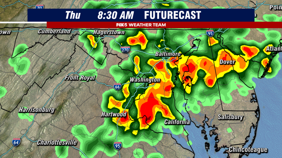
Rain is likely to be widespread during the morning hours, with the threat of some torrential downpours to be mixed in with the precipitation field as well.
Flash flooding will be a concern in some of these storms, as they will likely be slow-moving. Plan on some extra time for your morning commute, as the rain is likely to slow traffic to a crawl around our region.
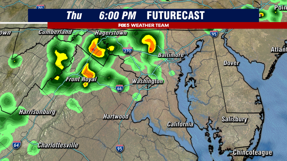
By the afternoon hours, the atmosphere will slightly stabilize as the surface boundary is forced northward.
This will make activity during the afternoon more of the scattered, hit-and-miss variety as opposed to washout. It will be an extremely humid day, however.
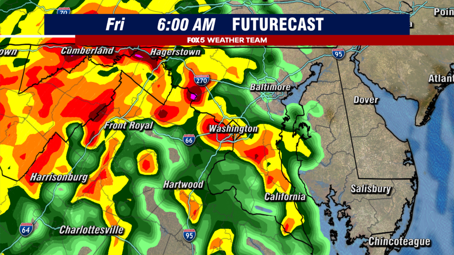
By Friday morning, the center of Debby's remnants will begin to work their way northward up the I-81 corridor. Another round of extremely heavy rain is anticipated, starting as early as the midnight hours for our western areas, but heaviest in the D.C. metro area closer to the morning commute timeframe.
Once again, downpours could be extremely heavy and flash flooding risks will be a major concern in those areas that see the heaviest rains.
Travel could be very tricky during the first half of Friday. Expect delays.
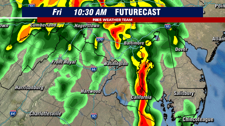
By the mid-morning hours, the remnants of Debby will begin to transition from being more tropical in nature, to being more subtropical – becoming more like a inland nor'easter.
Will Tropical Storm Debby bring tornadoes to the DC region?
As drier air wraps around the center and interacts with Debby's moisture field, thunderstorms are expected to blossom across our eastern zones as the primary low-pressure center lifts northward.
This creates an area where there will be an elevated risk for severe weather, notably tornadoes, due to the strong shifting in the winds between the surface and mid-levels of the atmosphere.
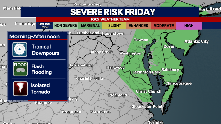
Debby has already spawned several tornadoes in the Carolinas, and the threat is likely in parts of our region as well, mostly along and east of the I-95 corridor.
It should be noted we are not expecting a tornado outbreak. We just do not want people to be caught off guard if a few tornado warnings do come up in our region on Friday.
The tornado threat will wane as the day progresses, however, and we should be in the clear by the late afternoon as Debby moves out of our region.
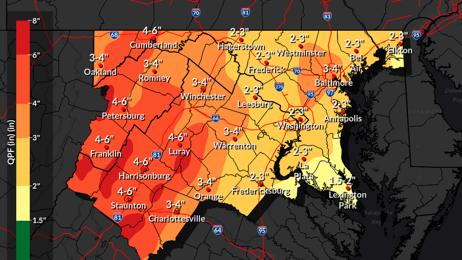
How much rain will Debby bring to DC region?
For the entire event, the National Weather Service expected a general 1-3" of rain along and east of the I-95 corridor, with 3-6" of rain possible for areas to the west of DC, centered around the I-81 corridor.
Locally higher amounts are certainly possible due to the nature of tropical downpours. It should easily be the most rain the entire region has picked up since the start of summer.

Tropical Storm Debby flood watches
As of Wednesday night, flood watches have been posted for Thursday and Friday in anticipation of heavy rains in the zones where the National Weather Service feels flooding concerns are greatest.
This does not include the D.C. and Baltimore metro regions as of the writing of this article, but these could be expanded Wednesday night or Thursday to include more of the region depending on where the heaviest downpours look like they may set up over the next day.
The good news in all of this? We do need rain.
Though some will be lost to runoff, and flooding is never good, the rain that does fall will help put a dent in the drought situation that we have had here in the D.C. region. It will not eliminate it, but it will help.
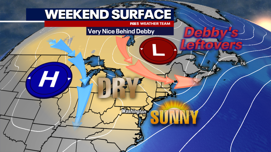
Then, on the other side of Debby, we will get one of the nicest stretches of weather we have had around our region the entire summer; warm afternoons in the 80s, low humidity, and pleasantly cool nights.
The weekend right through early next week looks like a real treat!