

Tropical Storm Debby to bring heavy, but needed rain to DC region
Tropical Storm Debby set to drench DC with much-needed rainfall
By the end of the week, southern winds will increase and lift Debby northward, with Thursday night - Saturday morning being the most likely time of Debby's slow passage through the region. FOX 5 meteorologist Mike Thomas delivers the forecast.
BETHESDA, Md. (FOX 5 DC) - This summer of 2024 has been a lot of things, but one way not to describe it would certainly be "wet."
The first half of summer (June 1 – Jul 15) was D.C.'s driest start to a summer since 1988 and tied for the third-driest on record.
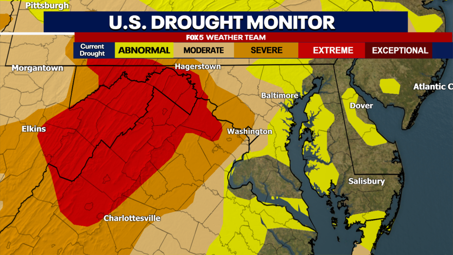
While late July and early August have brought more thunderstorms and more rain, much of the region remains in a severe to extreme drought. Our region needs rain, and with Tropical Storm Debby forecast to track northward in the days ahead, we just might have our best shot of the summer so far at putting a major dent in the current drought situation in our region.
Is Debby still a hurricane?
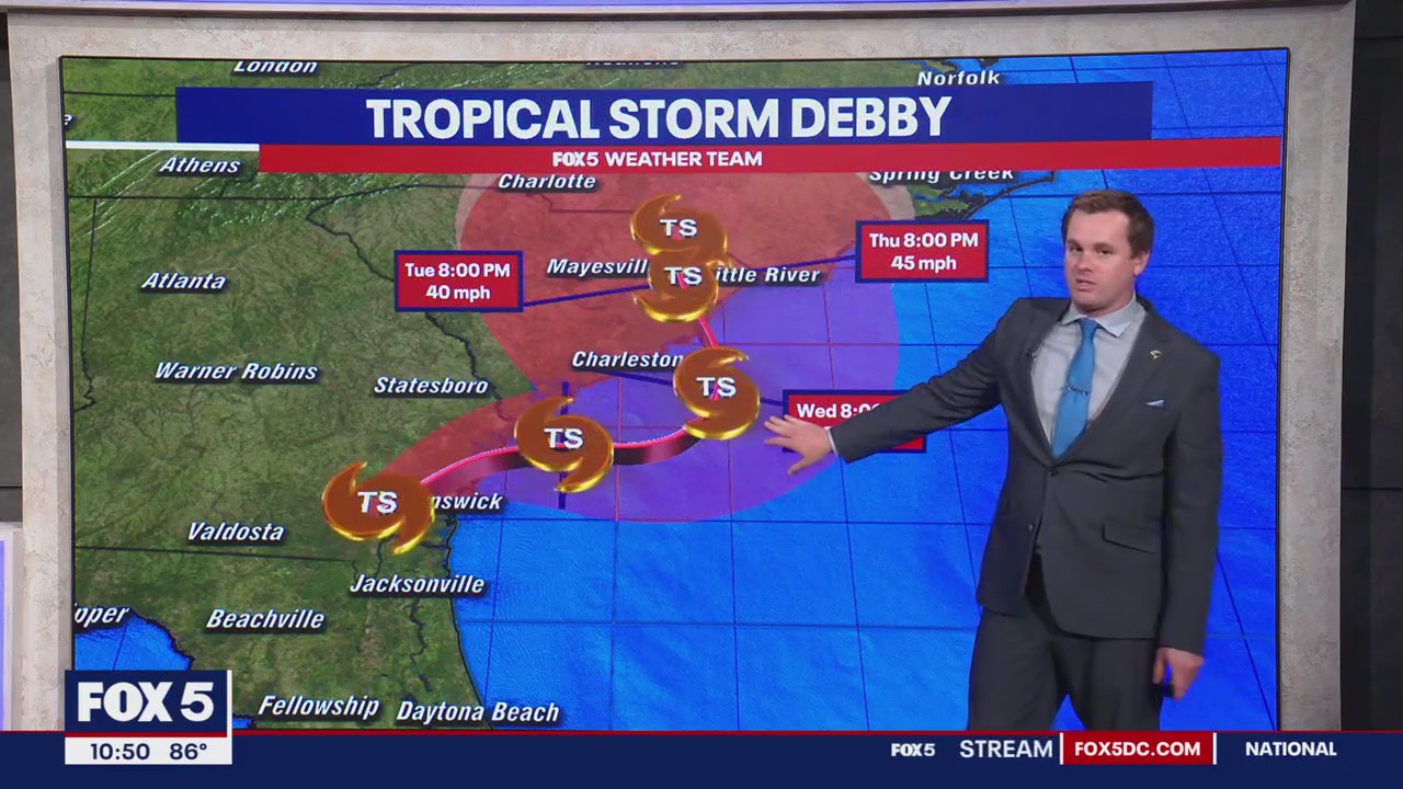
After making landfall as a hurricane in northern Florida on Monday morning, Debby has weakened to a tropical storm, and as of Monday night had crossed into Georgia.
Debby is forecast to eventually drift off the coast into the warm Atlantic waters off the Georgia and South Carolina coastlines, where she should maintain tropical storm intensity.
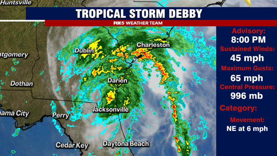
Her forward speed will slow to a crawl at this point, as upper atmospheric winds weaken. This means several days of heavy, likely flooding rains for parts of Georgia and the Carolinas, with the National Hurricane Center suggesting some areas around Charleston, South Carolina could see upwards of 20" of rainfall in the coming days.
Will Debby impact the DC region?
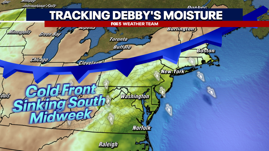
While Debby will remain far from the D.C. region during the middle of the week, the moisture she is propelling atmospherically will drift northward ahead of the storm.
Here, it will interact with a frontal boundary that will be sinking southward on Tuesday afternoon and evening, before stalling during the middle of the week.

Hurricane Debby path: Could DC region receive heavy rain from remnants of the storm?
The Washington, D.C. region could possibly see the remnants of Hurricane Debby move through later this week after the Category 1 storm brings heavy rain and catastrophic flooding concerns to parts of Florida, Georgia, and South Carolina.
Along and ahead of this boundary, the threat of heavy showers and thunderstorms will be elevated, though scattered in nature. While not expected to be a major issue midweek, localized flooding and severe weather are possible Tuesday through Thursday as this boundary remains present.
Tropical Storm Debby to bring rain to DC
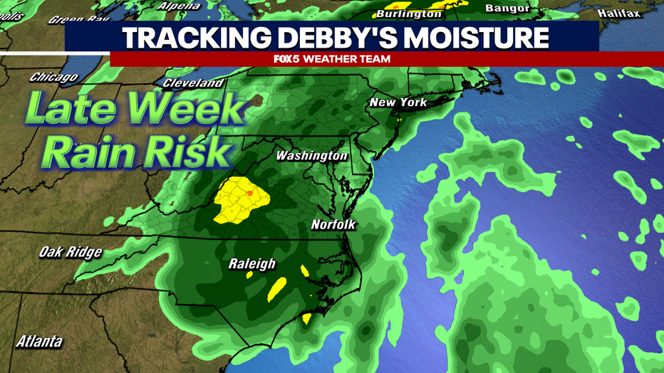
By the end of the week, southern winds will increase and lift Debby northward, with Thursday night - Saturday morning being the most likely time of Debby's slow passage through the region.
This would give the potential for something we have not had at all yet this summer…a washout. At this time, Friday looks like the most likely day of wall-to-wall rainfall in the DC region. Though it could start as early as Thursday night and end as late as midday Saturday, depending on Debby's exact forward speed.
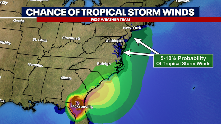
As the center of Debby is forecast to pass to the southeast of the immediate D.C. area, severe weather is not a big concern with this storm. In fact, the storm is expected to weaken enough by the time it gets here that tropical storm-force winds are not expected to be an issue.
It will likely be breezy, and gusts over 30mph will be possible, but as far as stronger gusts, those are most likely closer to the beaches like Ocean City, Maryland and Rehoboth, Deleware where winds coming off the open ocean will benefit from a lack of topographic friction to slow them down. But Debby is expected to be little more than a tropical depression when she passes by.
The biggest impact locally will be rainfall.
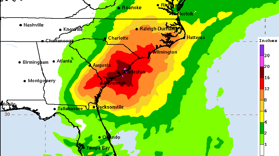
As mentioned previously, Debby's heaviest rains will be across coastal portions of the Carolinas simply because of her slow movement in this region and the fact the center will be sitting over a warm, open ocean, essentially creating an atmospheric highway of sorts for moisture to stream inland.
Flash flooding risks in these areas will be high, as many could see over a foot of rain in just a few days. These low-lying coastal areas are very prone to flooding during high precipitation events as well.
Closer to the D.C. area, the National Hurricane Center suggests that anywhere between 2" and 6" of rainfall is possible.
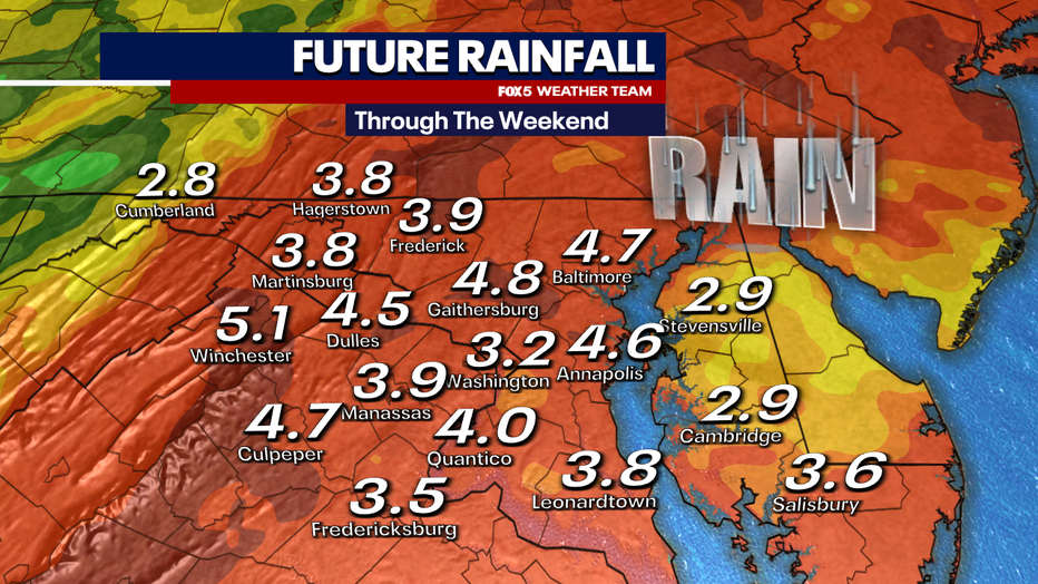
Model simulations for our region paint a soggy picture as well, with most suggesting anywhere between 3" and 5" of rain will be possible between Thursday night and Saturday afternoon.
Despite the dry drought conditions across the region, we will run the risk for some isolated flooding issues as the storm passes by our region due to the amount of forecast rain.
If you live in a flood-prone region, make sure you are paying attention to flooding alerts. The free FOX 5 Weather App is great for tracking these alerts.
While Debby will be one of the strongest systems that we have had to deal with this summer, it is hard to ignore the benefits that will come along with it.
We have already mentioned how much we need the rain to cut into the drought in our region. But as the storm pushes northward through the weekend, behind it will come a much drier, refreshing air mass out of Canada. Along with that, some cooler, but still comfortable, temperatures.
For a summer that has been the hottest in D.C. history, the cooler weather will bring heat relief to many – at least for a little while.…