DC Snow Forecast: Potential weekend storm likely to bring snow, cold rain, or mix of both

DC Snow Forecast: Potential weekend storm likely to bring snow, cold rain, or mix of both
The D.C. region is welcoming 2024 with our first chance of a winter snow storm in several years. FOX 5’s Tucker Barnes and Mike Thomas are tracking the potential weekend storm.
With 2023 now in the rear view mirror, we are welcoming the New Year 2024 with our first chance of a winter storm since about seven inches fell on January 3, 2022.
As with any type of precipitation being forecast nearly a week in advance, there are a lot of moving pieces to monitor and things that could change the track of the storm. Small changes can mean the difference between snow, cold rain, or a mixture of both.
READ MORE: DMV Winter 2023-2024 Outlook: Why we're expecting more snow, chance for blizzards in DC this winter
When could we see snow?
We are watching this upcoming weekend. The window of concern encompasses both Saturday and Sunday, though at this time the most likely time window appears to be after lunchtime Saturday lasting up until the early morning hours of Sunday. Various weather guidance shows rain from an early start on Saturday, to a later start Sunday though.
This is important as a storm that comes during the middle of the afternoon is more likely to feature some rain/mix which could impact snow totals, while a storm that comes after sunset or overnight is more likely to have more impactful snow. The exact timing will be something to monitor in the days ahead.
READ MORE: DC snow forecast: Chance for first significant winter storm next weekend
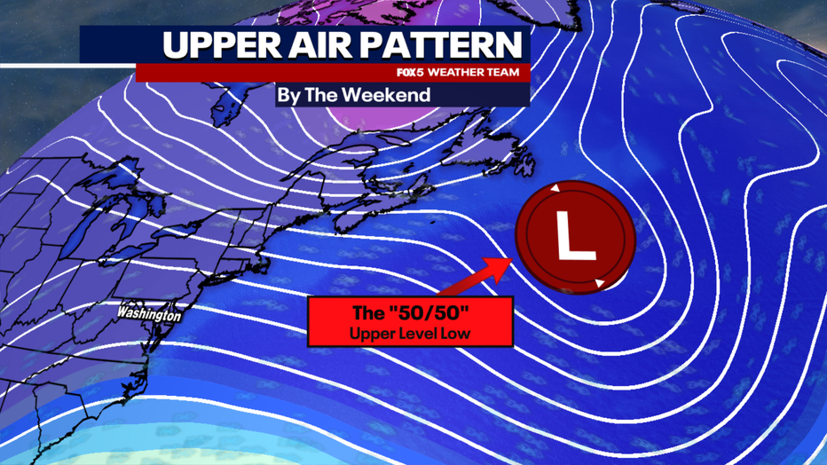
In Favor Of DC Snow: 50/50 Low & Greenland Block
A feature that weather forecasters watch very closely when forecasting a winter storm in the Mid-Atlantic and Northeast is a feature known as an upper level 50/50 low pressure area. This is a feature known by this name because it resides near the 50° latitude and 50° longitude lines on the globe, just off the coast of Nova Scotia, Canada.
This is important because it is essentially what forces cold air southward into the Northeast and Mid-Atlantic. As earth’s atmosphere is constantly in motion, how long this feature is present is what can increase our winter weather chances. That is where the Greenland block comes in, an anomalous area of upper level high pressure, which will be strengthening into the weekend.
This slows the progression of the 50/50 low northward, so it cannot escape. This results in cold air being filtered southward out of Canada and into the Northeast.
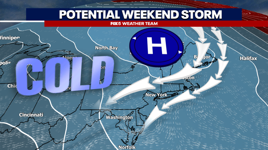
In Favor Of DC Snow: Surface High Pressure
At the surface, cold and dry polar air masses are centralized by strong areas of high pressure. Their motions are directed by the upper atmospheric pattern. On Thursday, a weak storm will pass south of the D.C. region, perhaps bringing a few showers or a bit of mix to our area. While harmless in terms of accumulations, this storm is the key to what happens next.
It is this storm that will turn northward, become energized by the polar jetstream, and deepen into a strong low that will help develop into the 50/50 low that will impact the weekend storm. Models have been in good agreement that surface high pressure will be directed southward around the 50/50 low, setting up north of Lake Ontario.
This is key, and this keeps the Northeast and Mid-Atlantic in a prevailing northerly surface wind pattern. This not only forces cold air southward, but traps it due to our proximity to the Appalachian Mountains. As the weekend storm turns out of the Gulf and turns northward, it’s the fact that cold air is trapped at the surface that leads to ice, mix, or snow, depending on the depth of that cold air.
While we need to watch for exactly how strong the cold air mass will be when it starts pushing southward, right now most guidance does put it in a rather ideal zone for our region.
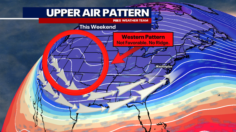
Against DC Snow: Western Pattern
Getting a good winter storm or blizzard is a lot like making a puzzle: you need all the pieces to fit. Right now one of the bigger pieces that is not fitting is the lack of any western ridge component. That is to say, the lack of any strong area of upper level high pressure across the western United States that would buckle the polar jet southward, essentially supercharging our storm system, and dumping even more cold air into the region for the storm to tap into. The pattern appears to be much more zonal, or flat. This is where the upper level winds are primarily west to east, as opposed to more of a northwestern component.
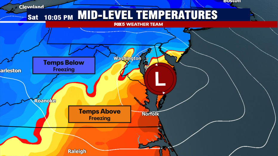
This is concerning for a couple of different reasons. The first is that it could allow the storm to trend farther inland in its tracking. This in turn pulls in more of a southeasterly wind as the storm approaches our area. This floods the middle atmosphere with Atlantic warmth, with above freezing temperatures pushing coming in above the surface. With high pressure still set to the north of us pushing in the cold, this is a scenario that commonly leads to a cold rain, mix, or ice event as opposed to a pure snow event, or one that changes precipitation types.
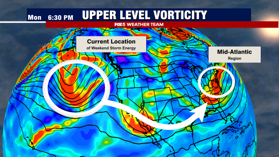
Against DC Snow: Storm Energy
Another feature to watch with this is the upper atmospheric energy that will lead to the formation of what could potentially be the aforementioned winter storm. Right now, that energy is in an area of cold open ocean water in the North Pacific, just south of the Aleutian Islands. This is a part of the world that is notoriously difficult to get reliable data from, due to the lack of direct upper level observation.
Computers instead do a lot of estimating the strength of features based off of satellite data. The energy from this storm is not forecast to hit the west coast of the United States until Wednesday, when it will be more accurately sampled by ground station and balloon measurements. Until that point, be weary of snowfall data and storm track data making the rounds on social media, as it is likely to shift and change greatly in the days ahead.
After it comes ashore, it is primarily a piece of energy in the southern branch, without any northern component to it. As mentioned above, without an added northern component, the storm may have difficulty strengthening until it gets further to the north. Thus, there is a concern that some of these early simulations could show a much stronger storm than will actually be present in a few days, but that will be sorted out in the days ahead. It is something that could vastly impact the forecast, however.
What Are Our Early Thoughts?
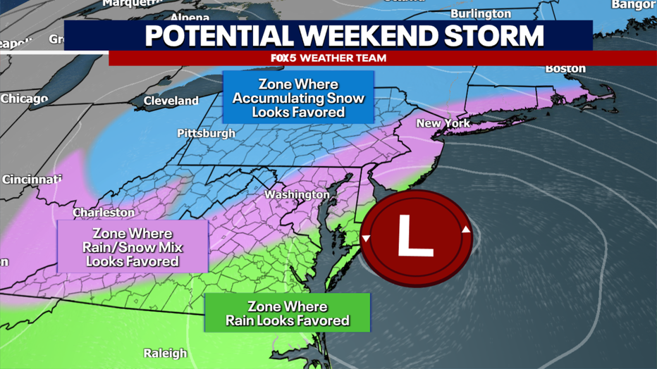
With the atmospheric setup, I am not yet convinced that this is the blizzard that many snow lovers have been waiting on since the January 2016 storm put the DC region under a blizzard warning. The storm may not strengthen enough without a polar jetstream enhancement to keep enough cold air in place for the D.C. and Baltimore corridor.
With the lack of any significant ridge across the western United States, the storm could trend inland and the D.C. region, while they may see some "bookend" snow on the front and back sides of the storm, may deal with a lot of mixing with sleet and rain.
We will continue to update you throughout the course of the week. Right now, the pattern suggests that the risks for the most substantial snows will be west and north of the immediate D.C. region. That does not mean there is not any threat for accumulating snow closer to D.C. A few inches is possible, but it may be that some mixing will cut back on totals near the big cities.
Those along the I-81 corridor and the mountains of Virginia and West Virginia, however, should keep a keen eye on this weekend's storm, as these are regions most likely to see winter storm totals. As is the normal with just about any winter storm, those in elevated areas will have the best shot at the highest totals, which could be over a foot in the mountain areas.
We have several days to monitor this storm, though we most likely won't have a good idea on what the exact track will be until we get closer to the middle of this week, likely later on Wednesday or Thursday morning when the upper atmospheric energy hits the West Coast. Until then, be careful what you read on social media.
The FOX 5 Weather Team is on it, and we will continue to provide you with timely updates throughout the week.

