DC prepares for more rain, wind Friday ahead of Arctic blast, snow risk next week

DC prepares for more rain, wind Friday ahead of Arctic blast, snow risk next week
FOX 5 meteorologist Mike Thomas has your weather forecast for the weekend.
BETHESDA, Md. (FOX 5 DC) - Saying that this winter has been wet is an understatement.
Going back to the start of meteorological winter on Dec. 1, D.C. is off to its wettest start to a winter in history.
READ MORE: DMV Winter 2023-2024 Outlook: Why we're expecting more snow, chance for blizzards in DC this winter

With nearly ten inches of rain so far this winter, it has been 45 years since a winter started even close to this wet, and we could add even more to this total this Friday night into early Saturday as another intense winter storm pushes through the Midwest.
READ MORE: DC-area airports set daily rainfall records

Much like the storm that came through on Tuesday, this storm will be centered well to the west of the D.C. region.
This places us firmly in what is known as the warm sector of the storm, meaning there is no threat that this storm is going to bring us another round of winter weather.
READ MORE: DC snow forecast: Arctic blast Monday; chance for snow into Tuesday?
A difference between this storm and the one we went through this past Tuesday, however, is the timing. Most of the daylight hours should be dry on Friday, with the morning hours even featuring some sunshine.
It’s around the evening commute that the rain should start to move into the region.

Though it is not supposed to last as long as the event this past Tuesday, the rain could be heavy for some time during Friday night.
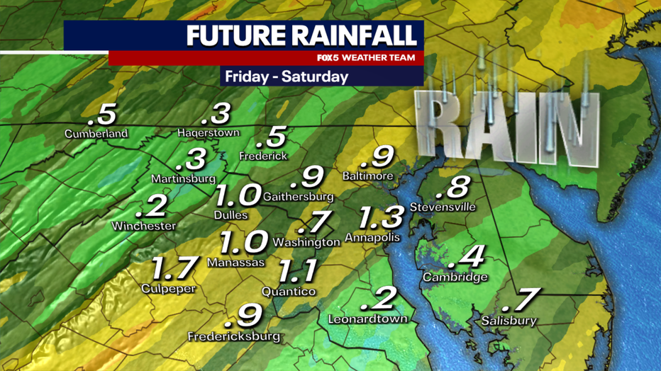
Most of the area is looking at about half an inch to an inch of rain with this event.
Some localized areas could get a bit more heavier downpours. While that would not be a lot given the time of year, when it comes on the back of an event where most of the area picked up 2-3", there could be some flooding concerns once again in the D.C. region.

As the storm moves through the Great Lakes area, it is expected to rapidly intensify. This will bring blizzard-like conditions to parts of the Midwest, including Chicago on Friday where over a foot of snow is possible.
In our region, the rapidly strengthening storm means another round of gusty winds, winds that could potentially peak at 40-50mph on Friday night.
With the heavily saturated soils and given the time of year, another round of downed power outages will be possible for parts of the DMV during the late evening hours into early Saturday.

Unlike the Tuesday event where the rain lasted for most of the day, this system should be a much faster one for our region.
Most of the Mid-Atlantic will dry out before sunrise on Saturday. The one exception will be the mountain areas to the west, where westward-facing slopes can expect several inches of snow to fall.
When news breaks, stream FOX 5 DC anytime. Get the FOX Local app on your smart TV.
While the rain will exit, the winds will not. Saturday will be a breezy day with falling temperatures and wind gusts between 30-40mph possible for much of the day. Winds will improve by Sunday, but it will be a seasonally cold day with highs only in the 40s.

Speaking of cold, this winter has so far lacked any sort of extreme or extensive period of cold so far. That is expected to change as we begin the new week next week.
A strong area of arctic cold will drop out of Canada into the Pacific Northwest to start the weekend, where temperatures could be some 50-80° below normal in parts of Montana. Air will be cold enough to give exposed skin frostbite in just minutes.
While this air mass will moderate as it comes eastward into the early workweek, it is expected to bring an extended period of cold weather to the D.C. region starting next week.

Along with that cold could potentially come D.C.’s best chance at accumulating snow so far this winter.
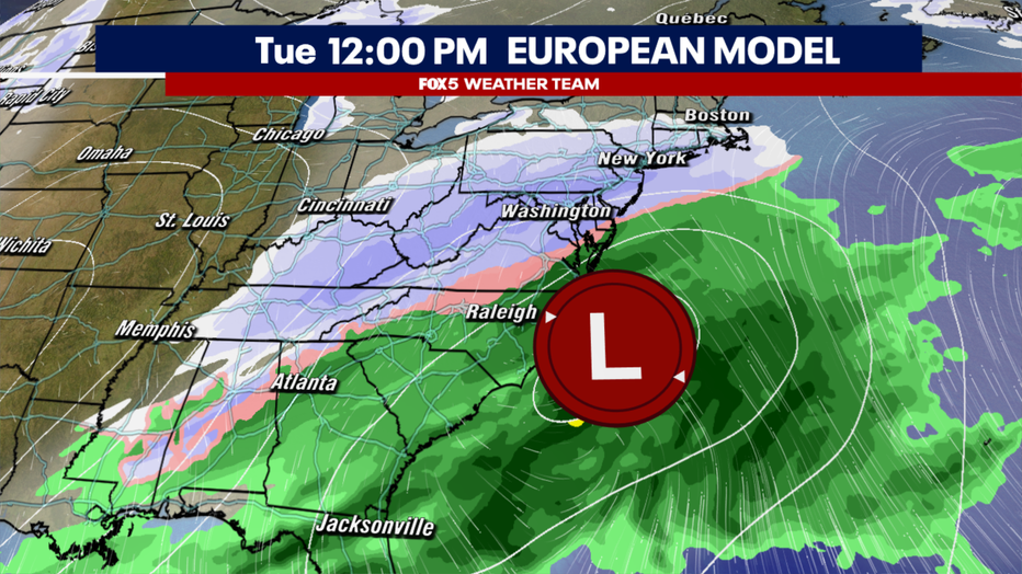
Just beyond the Martin Luther King Jr. holiday on Monday, weather models are battling the risk for some snow in the Mid-Atlantic and Northeast centered around the Tuesday time period.
Unlike the storms we have had this week though, this storm comes on the back of a much shallower dip in the jet stream, one without a particularly strong southern moisture connection.
There is still a great deal of uncertainty as to how much moisture will be present into early next week and how well it will organize.
There is the threat that the cold, dry air mass crossing the country will essentially bulldoze any sort of organized moisture off the eastern coastline. This could prevent an organized storm from developing, and leave the region with just the risk for some lighter snow showers as an upper low passes overhead on Tuesday afternoon.
With this potential storm five days away though, we still have plenty of time to watch it and monitor forecast trends.
The Fox 5 Weather Team will continue to keep you up to date with the latest.

