

DC area expecting heavy rain, wind as 2 powerful winter storms eye central, eastern US
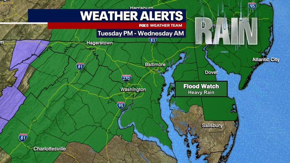
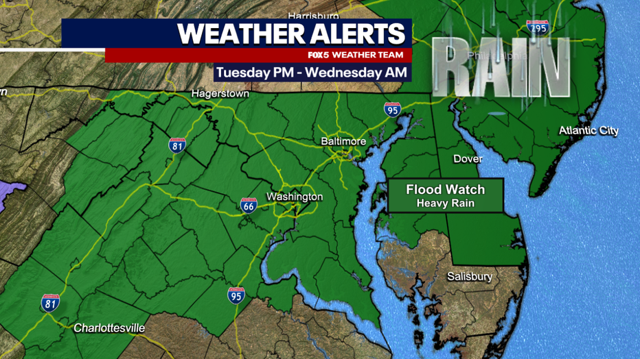
Coastal Flood Watch in effect Tuesday across DC region
Heavy rain and wind is expected to pummel parts of Virginia, Maryland and D.C. on Tuesday, FOX 5 meteorologist Mike Thomas has the latest forecast.
DC area expecting heavy rain and wind Tuesday, Wednesday. Here’s what we can expect
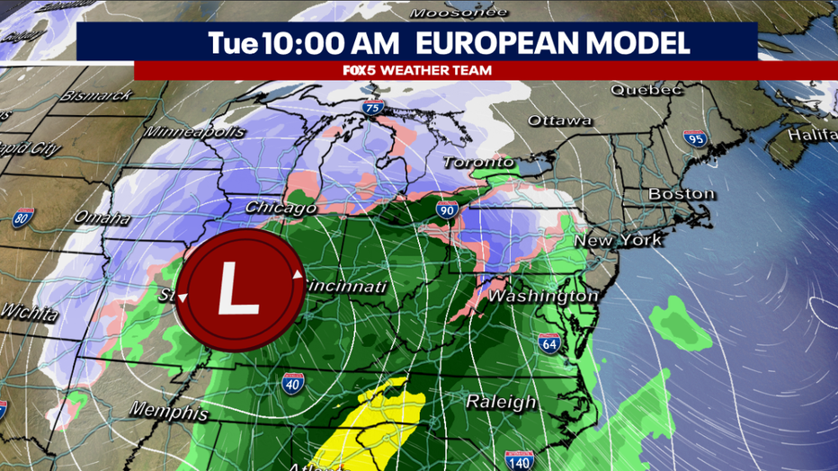
WASHINGTON - Two powerful, potentially blizzard-level storms will impact the eastern half of the country this week. One during the early workweek, with the second coming at the tail end. On Sunday, the first blizzard warnings were issued ahead of the early week system for parts of the Southern Plains, where the system will take form on Monday.
This storm is expected to be among the strongest this winter, but similar to the previous system, it is not expected to bring the immediate D.C. area anything other than rain.
HAZARDOUS WEATHER CONDITIONS | WHAT WE CAN EXPECT
- Flood Watch in effect from January 9, 01:00 PM EST until January 10, 07:00 AM EST
- Coastal Flood Watch in effect from January 9, 01:00 PM EST until January 10, 07:00 AM EST
- Wind Advisory in effect from January 9, 03:00 PM EST until January 10, 01:00 AM EST
IMPACTS:
- A period of moderate to heavy rain is likely to overspread the area Tuesday afternoon and evening. Rainfall totals of two to three inches are expected with localized amounts up to four inches possible.
- Flooding caused by excessive rainfall is possible. Excessive runoff may result in flooding of rivers, creeks, streams, and other low-lying and flood-prone locations. Creeks and streams may rise out of their banks. Flooding may occur in poor drainage and urban areas. Low-water crossings may be flooded.
- Gusty winds could blow around unsecured objects. Tree limbs could be blown down and a few power outages may result. Use extra caution when driving, especially if operating a high profile vehicle. Secure outdoor objects.
READ MORE: DMV Winter 2023-2024 Outlook: Why we're expecting more snow, chance for blizzards in DC this winter
The early week storm is expected to have major impacts on travel across the eastern half of the country. Heavy snow and blowing winds could cover highways and delay the airways from Monday evening through Wednesday morning across the eastern half of the country as the storm intensifies.
Aside from the likely blizzard conditions across parts of the Plains and western Midwest, the National Weather Service is warning of possible strong tornadoes on the storm's southern flank. Parts of Louisiana, Alabama, Mississippi, and Florida are outlooked for severe weather on Monday, which then expands up through Georgia and the Carolinas on Tuesday.
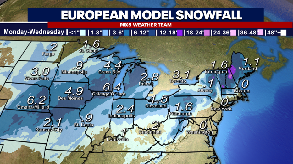
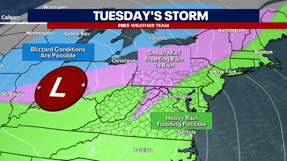
Many people falsely believe that in order for a storm to be considered a blizzard, it has to drop over a foot of snow. This is not the case. You see in the image above, the forecast snow totals at first glance may not break any records across the Midwest. While some areas could approach or exceed a foot of snow, many will fall short of that amount.
Many times, a blizzard actually has nothing to do with snowfall amounts, and instead is focused on wind, and visibility. The criteria for a blizzard is the same both here in Washington, D.C. and Chicago, IL. Winds exceeding 35mph resulting in less than a quater mile visibility or more for at least three hours.
It is the wind component of this storm that will cause the harshest conditions in the Midwest.
In the Mid-Atlantic region, there are some concerns that our western zones could start with a little bit of mix or ice.
These would mostly be confined to the elevated regions out to the west of the I-81 corridor, and the upper elevations of the Blue Ride Mountains as well. For the immediate D.C. area, the threat is once again rain.
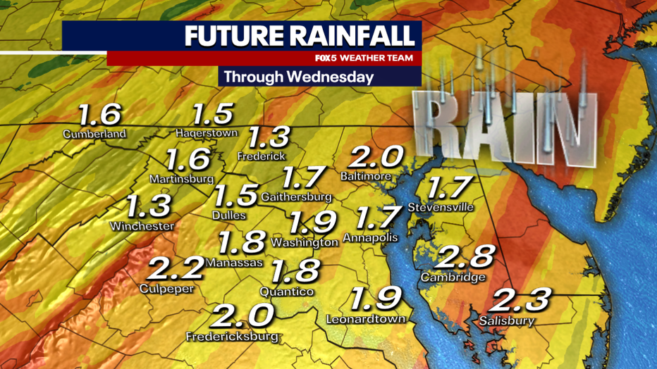
Unlike this past weekend though, this rain could be very heavy at times, with much of our area expected to pick up between 1.5" and 2.5" of rainfall.
All this comes on the heels of not only D.C.'s fourth-wettest December on record, but the first Saturday of the new year that featured over an inch of rain, and you have some very saturated soil.
With heavy rainfall rates expected, the National Weather Service issued flood watches for the entire D.C. region early on Monday morning for the upcoming storm. While we will once again avoid the winter weather, travel could still be treacherous due to heavy downpours most of Tuesday afternoon and evening. We always remind you never to cross any flooded roadways you come across.
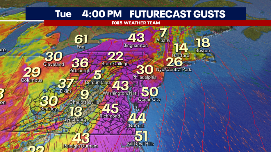
We already mentioned the wind component across the Midwest, but the East Coast will not be spared some of the stronger gusts from the powerful storm.
D.C. could see wind gusts exceeding 40mph on Tuesday afternoon, while coastal areas could see wind gusts exceeding 50mph. This time of year, when combined with the saturated earth, these winds will likely be enough to bring down a few trees and power lines in our region on Tuesday. In addition, the winds are likely to lead to air travel delays throughout the Mid-Atlantic and Northeast, while severe weather could lead to delays in the Southeast.
This is a very large and dynamic storm system that will have large impacts in the front half of the week. It should exit the Northeast by Wednesday afternoon.
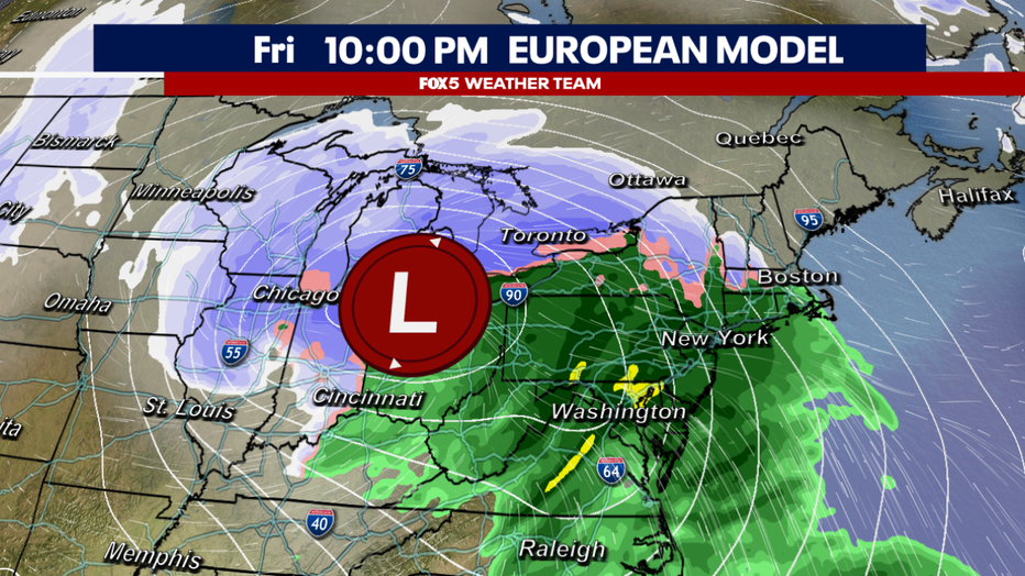
After not more than a few days to dig out in the Midwest, and dry off here along the East Coast, the early week storm system will quickly be followed by another powerful storm in the Thursday to Saturday time-frame. Forecast to take a very similar track to the early week storm, this late week storm is expected to bring further blizzard conditions to the western Midwest and yet more rain to the East Coast.
We will be tracking this storm throughout the week, as any eastern wobble in its track could potentially mean some wintry mix getting closer to the DC area. At the moment, however, it does appear to be a rain event for the D.C. area, focused on Friday.

These two storms come on the front end of what will be the coldest air mass to hit the continental United States so far this winter. The famed polar vortex will be paying a visit to the Pacific Northwest by the weekend.
By Saturday morning, temperatures in parts of Montana could be between 20-40° below zero, anywhere from 60-80°F below normal. Seattle could even fall into the teens or lower 20s during the peak of the cold. This cold is expected to expand eastward into early next week. And, if the storm track stays active, it just may bring some winter weather chances our way as well.