Winter storm 'bomb cyclone' expected to cause travel nightmare across DC region ahead of Christmas weekend

'Bomb cyclone' expected to cause travel nightmare across DC region ahead of Christmas weekend
A powerful, winter ‘bomb cyclone' that could create blizzard conditions for parts of the upper Midwest and Great Lakes is expected to bring freezing temperatures and damaging winds to the D.C. region creating a travel nightmare ahead of the Christmas holiday weekend.
WASHINGTON - Winter officially begins Wednesday afternoon for the Northern Hemisphere, and it is going to kick off with quite the chaotic forecast.
For the better part of a week we have been tracking the potential for a big storm in the eastern half of the United States. While at one time it looked like it could mean big snows for the major cities along the I-95 corridor, weather models have shifted that narrative to greater impacts from snow and winter weather to areas closer to the upper Midwest and Great Lakes.
That does not mean that our local region will dodge all the impacts though, as some drastically falling temperatures and gusty winds could all lead to travel disruptions across much of our region.
Impact #1: Snow, Ice, and Rain
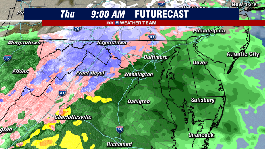
The first threat we have to monitor is how early the moisture starts pushing in on Thursday morning. The sooner it gets here, the more we could be dealing with similar issues like we dealt with last Thursday, in terms of ice and perhaps even some snow issues for parts of our region.
Now, just because of the nature of what we call cold air damming events, it would be the northwestern zones that have the greatest threat of impact from this weather. So for those hitting the roads on Thursday morning, if you are traveling along the I-81, the I-70, or the I-70 corridors just be aware there could be some ice and snow issues in those regions. Winter Storm Watches were actually put up for the mountain areas earlier this afternoon ahead of the storm.
As we get to and beyond the lunchtime hours though, cold air will erode, and the region will primarily deal with plain old rainfall risks though the evening hours. But travel by roadways will be safer in the evening hours, as opposed to the morning hours.
For the immediate D.C. area, the best chance of seeing any winter weather will actually be on the back side of this system on Friday morning into Friday afternoon.
While it would be unlikely to be anything significant, some weather models have suggested that we could see a brief burst of snow as a powerful reinforcing cold front crosses our region. I will say, that weather models can sometimes overdo this, as many times the mountain range to our west can delay the onset of cold air, as cold air is heavy, and it takes some additional time to cross the mountains. In this case however, the strength and depth of the incoming cold pool of air is rather extreme.
There is a legitimate chance that we could see a touch of snow on the back side of the system. Though it would not come with any accumulation. What is a virtual guarantee with the passage of this front though is that winds will start to get awfully gusty…
Impact #2: Gusty Winds
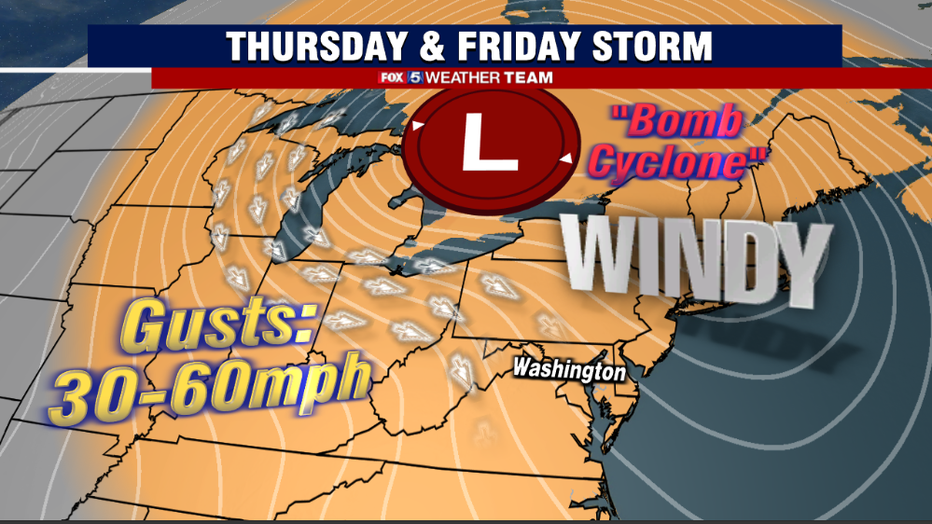
A term that we have become more accustomed to in recent years thanks to social media, a "bomb cyclone" is simply a rapidly intensifying storm system.
While more common over water than land, the upcoming storm this weekend is expected to classify as a bomb cyclone as the center of the storm rapidly lowers in pressure. This has the consequence of unleashing an incredible amount of wind energy. While yes, snowfall and blizzard conditions through parts of the Upper Midwest will enhance some delays, it is the strength of the winds that could exacerbate delays through the Midwest, Northeast, and Mid-Atlantic.
Especially for those planning to hit the skies during the last couple days of the workweek. Winds in parts of the Midwest could gust in excess of 60mph, and the threat for road closures is possible just due to winds alone.
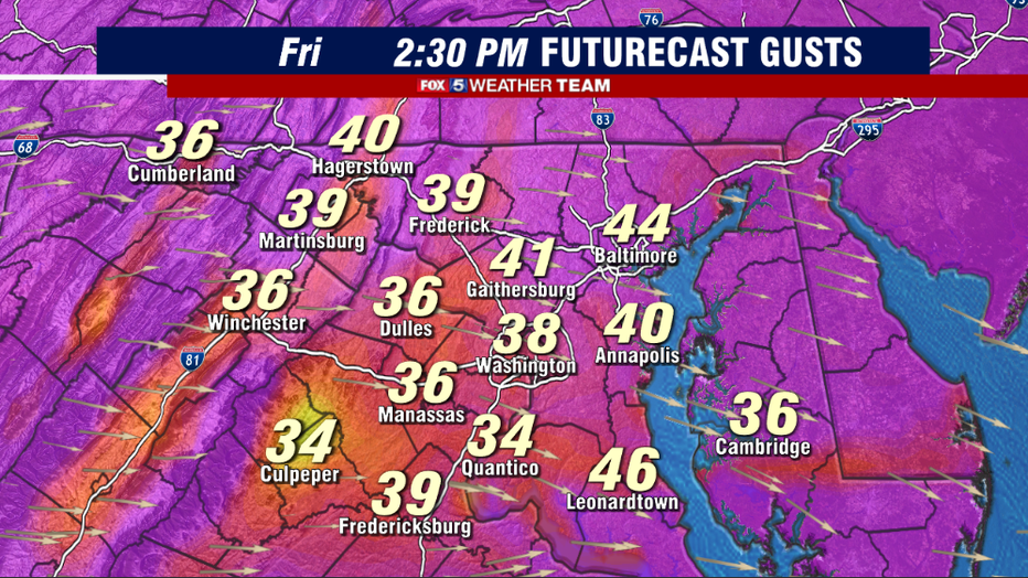
Locally, winds could peak Friday afternoon between 40-45mph around the immediate D.C. region, with isolated regions seeing gusts exceeding 50mph and the mountain regions to the west potentially exceeding 60mph for a period of time. Please be warned of possible travel delays due to the winds and check ahead with your flight times.
Monitor the Chesapeake Bay Bridge as well, which is prone to closures when winds get too extreme.
Impact #3: Dangerous Flash Freeze
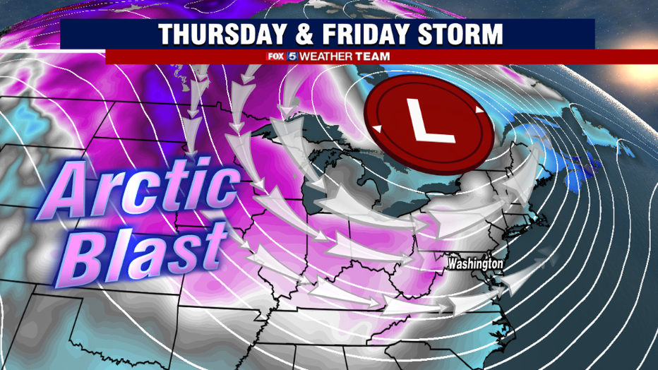
Perhaps the most impactful part of this system for the weekend is the impact that it will have on temperatures. Some of the coldest air we expect to experience for the entirety of this winter is forecast to come down on the other side of this system.
Subzero temperatures are forecast for parts of the Plains, and the cold air will be elongated into the eastern half of the country and send D.C.'s temperatures into the teens by the sunrise hours of Saturday.
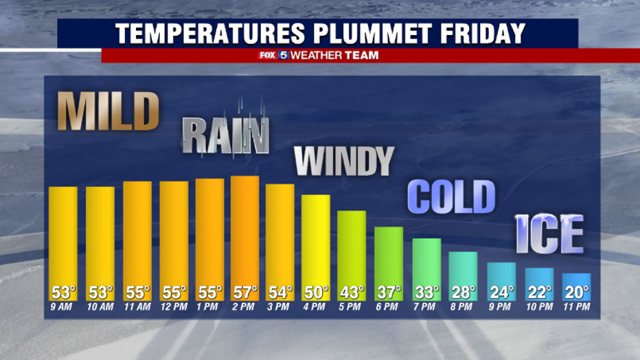
A major concern and something that could make travel delays even worse across the region is what we call a flash freeze. This is when a wet surface has not had adequate time to dry before temperatures tumble below freezing, in this case potentially quickly into the 20s, and this can cause wet surfaces to turn to icy surfaces really quickly. If you plan to travel during the late afternoon and evening hours of Friday please use extreme caution.
Flash freezes are almost impossible to treat for, because there rain initially would wash any pre-treatment away. Black ice will be a major danger in the evening on the roadways, not just in our region but across much of the Northeast at temperatures plummet into the teens in many locations.
Impact #4: Christmas Cold
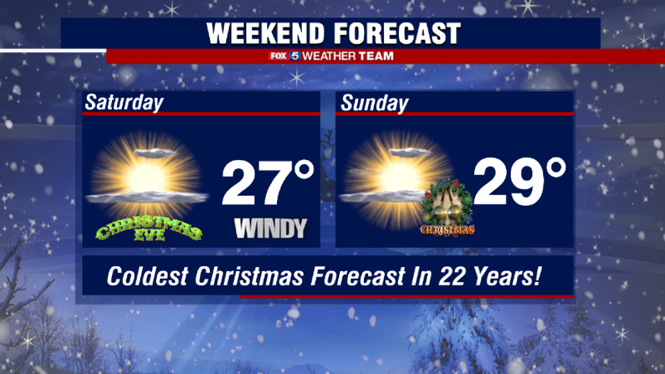
This major storm all results in one of the coldest Christmases the D.C. region has seen in decades. The District of Columbia has not had a Christmas where temperatures failed to break 30° since the year 2000. Low temperatures could be the coldest in some areas on the holiday in over 30 years, since the extreme Christmas of 1989.
The good news is that skies should be mostly sunny, though as the powerful storm shifts north of the Great Lakes it will occasionally bring some periodic cloud cover and perhaps even a stray snow flurry or two, with the greatest chances on Saturday afternoon.
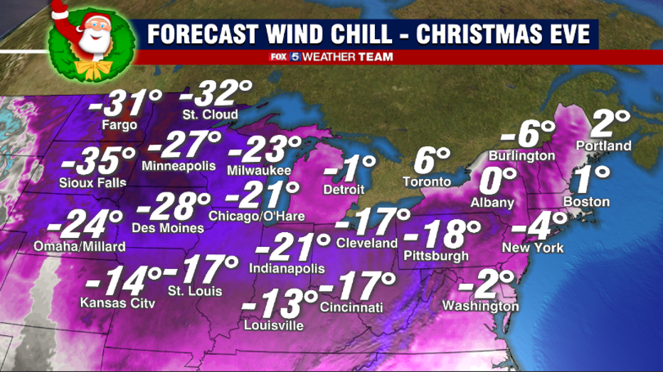
The persistently gusty winds on Christmas Eve will send those wind chills to downright bone chilling levels. It is not often we see the potential for sub-zero wind chills here in Washington, but that potential exists during the morning hours of Saturday.
Cold will be downright dangerous during the holidays across the Northern Plains and Upper Midwest, where (-20°) to (-40°) wind chills will be possible through the holiday weekend. Winds should subside a bit by Sunday, but for those heading out to early morning services on Christmas morning, expect "feels like" temperatures to be in the single digits with air temperatures in the teens to start off Christmas morning.
Hopefully Santa is bringing some extra layers! Please check on your neighbors, the elderly, and beware of the dangers of the temperatures on pets. It may be a good holiday to let those outdoor pets inside to enjoy holiday warmth with the family.
Looking Ahead
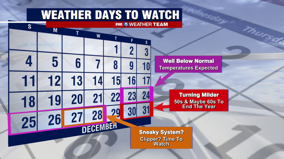
As we look beyond the Christmas holiday weekend, the cold temperatures will slowly fade through the course of next week. Though Monday, Tuesday, and Wednesday are going to straggle to see high temperatures climb out of the 30s. Several weather models have hinted at the potential for snow showers or flurries during the Tuesday-Wednesday time frame that we may need to monitor for, but this is a low confidence forecast at this time.
For those who are just not ready for this level of cold this early in winter, we do have good news. Temperatures are expected to warn considerably by the New Years holiday weekend. While it is a long range forecast, current model projections for New Years Eve and New Years Day both range between 55-60°.
There is some hope for better weather to start 2023…unless you are a snow lover! Stay warm, stay safe, and stay tuned for more updates throughout the week!

