DC region braces for first possible significant snowfall of 2021
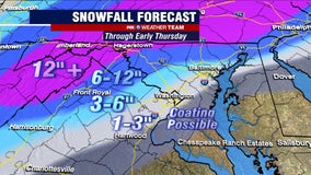
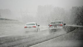
As the temperatures stay low and the wind picks up, our area is bracing for what could be the first significant snowfall in quite some time.
How much snow? Devil in the details for possible winter storm Sunday and Monday
Thursday marks not just the fourth day of the workweek, but also the fourth day in a row that all the major weather forecast computer models are showing the threat for measurable snow in the Washington, D.C. region to end the weekend. Consistency is important in the world of weather forecasting, which is one of the reason that the storm has been all the buzz on social media recently.
Winter threat remains for early next week with snow possible Sunday into Monday
Weather models yesterday afternoon caused quite the stir on social media when the European model called for over two feet of snow early next week across the Washington, D.C. region. We always advise caution with such extreme amounts however. That is not to say that storms like that cannot happen, as we have just passed the five year anniversary of the last storm that did just that, the blizzard of January 2016. Conditions for such storms typically need to be ideal though, they are the "perfect storms" in many ways because the atmospheric setup needs to be just right. As things stand right now, we do not believe we are dealing with such a case here. In fact, the very same model that showed over two feet yesterday is now just showing half a foot as of this morning. Considerably less...but still impactful. Still very much a storm worth watching into early next week.
Snow showers possible Thursday; eyes on late weekend storm risk
A little over a month after the winter solstice and Reagan National, D.C.'s officially measuring post for snowfall, has officially picked up the first measurable snow of the winter season. Though just 0.3", it was the most snow the District has picked up in over a year, and accounts for 50% of last years seasonal snowfall total. While last night's snowfall totals were far from memorable, we do have the potential of possibly adding to it within the next week.
Closings, delays and virtual learning announcements for Tuesday, January 26
Here are the latest closings, delays and virtual learning announcements for Tuesday, January 26 as winter weather moves through the D.C. region Monday morning.
Wintry mess threatens evening commute Monday night; more snow possible late week
Winter since the turn of the New Year has been pretty quiet in the D.C. region.
Winter Storm Watch in effect Monday for areas west of DC
The watch goes into effect Monday evening.
Winter weather possible Monday into Tuesday; lingering cold key to threat
The recipe for winter weather and snow is really not all that difficult. You simply need air cold enough overhead as moisture is moving in and boom...you have either freezing rain, sleet, or snow! In the Mid-Atlantic though, it is not always that easy to hold that cold air in place long enough to give a purely snow event. You need certain features to align atmospherically which is actually a rarer occurrence than I think many people realize. Yes, we do get some big blizzards here in the D.C. region, but they are far from an every year occurrence. The setup has to be just right.
Winter storm may threaten D.C. region early next week
A storm is expected to come on the heels of a very cold weekend in the Washington, D.C. region.
Paraplegic rescue dogs have the time of their of lives playing in Minnesota snow
A group paraplegic pups at a Minnesota shelter had the time of their lives playing in the snow.
First winter storm of 2021 may bring rain, sleet or snow to parts of DC region early next week
The FOX 5 Weather Team continues to monitor the potential of a winter weather event on Tuesday.
WINTER STORM TRACKER: Snow, sleet, and rain slams DC region Wednesday
There are only five days until the official start of winter, but Mother Nature decided to celebrate a little early this year with a winter storm that impacted a large portion of the D.C. region Wednesday.
Winter Storm Warnings issued in parts of DC region ahead of first storm of winter season
The beauty with any winter storm is always in the details, and the details with this upcoming winter storm are pretty messy.
Frederick County in Maryland declares snow emergency
Frederick County could see more than half a foot of snow and as a precaution, the city of Frederick declared a snow emergency Tuesday evening closing all city offices and non-essential operations. County schools are all virtual.
‘This is one thing our kids won’t lose this year’: School district gives virtual students snow day
A West Virginia school superintendent said she will not deprive her district’s students of the first snow day of the year, despite many children learning from home amid the COVID-19 pandemic.
Snow storm forecast: DC region braces for midweek winter weather
It seems like it has been quite some time since D.C. has had to deal with a decent winter storm. In reality, it has been about 2 years.
Snow removal crews grapple with COVID-19
You can now add snow removal to the long list of things that have had to change because of COVID-19.
Gatlinburg's SkyBridge dusted with snow to create 'winter wonderland'
Snow creates 'winter wonderland' at Gatlinburg's SkyBridge.
Winter is coming! Snowflakes spotted in western Maryland Tuesday
Some of the first snowflakes of the season were spotted falling in far western Maryland Tuesday morning.
NOAA’s winter forecast is out: Bitter cold for some, warmer weather for others
The CPC issued its winter outlook on Oct. 15, which covers the months of December through February.


