DC weather: Chilly weekend after snowflakes turn to rain Friday; eyes on Thanksgiving threat
Rare November snow expected in DC Friday before chilly rain takes over
A stormfront is expected to bring snow and some rain to the D.C. region Friday morning. FOX 5 meteorologist Mike Thomas delivers the forecast.
WASHINGTON - Snow … in November? Yes, that is a thing, and it's not as rare as you think.
Sure, it is far from an every year occurrence, but as recently as 2018, D.C. recorded 1.4" of snowfall during the month of November. In fact, the monthly average for November snowfall is 0.1" of snow. Not something to write home about sure, but the point being that, yes, it can snow in November.
It can even snow a considerable amount. On Veterans Day, back in 1987, the city picked up nearly a foot of snow. By comparison, Friday's flakes will seem like a minor inconvenience at best.
Winter storm warning: Flurries possible in DC; western regions could see heavy snow

After being spoiled for much of the month of November, which continues to run as the warmest on record through the first two-thirds of the month, temperatures took a tumble on the back of some gusty winds along a cold front that swept the region on Wednesday night.
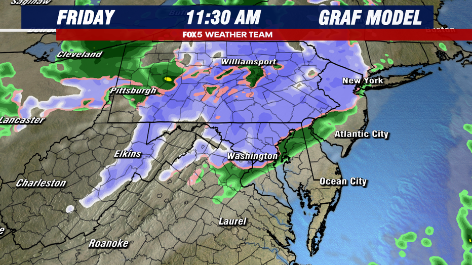
In its wake, a new storm quickly formed off the New Jersey coastline, which will push westward into the Northeast during the day on Friday. As it does so, it is expected to push some snow, and then eventually rain showers into the D.C. region during the morning hours of Friday.

When could the snow arrive?
One thing to note about this event is the timing.
For those up early enough, the day may actually start with some sunshine around the sunrise hours (6:59 a.m. Friday). The latest computer guidance suggests that clouds rise and the risk for snow showers enters the D.C. region during the middle to latter part of the morning, between about 9 a.m.-12 p.m. Because of this, temperatures are likely to be above freezing for much of the area by the time the snow starts to fall, certainly here inside the D.C. metro area. So any snow that does fall initially should melt pretty quickly.
Farther to the north, primarily north of I-70 where snowfall rates have the potential to be a little higher, there is the threat of some grassy accumulations or even an inch or two of wet snow, though this is not likely to last longer than a few hours.

Will the storm impact traffic?
Any morning snow should quickly transition over to mix and then all chilly rain heading into the afternoon hours Friday around D.C. Mix may hang on a little longer closer to the Mason-Dixon area, but those areas too will see an eventual transition over to plain old rainfall.
Any snow that had initially built up on the grass in these regions should pretty quickly melt away. Even without the winter weather, the afternoon and evening hours of Friday do not look fantastic.
It will be quite chilly with most stuck in the middle 40s, and the rain is likely to make for a rather miserable evening commute with wet roadways.

Weekend will be chilly
Thankfully, the weekend will offer some drier weather returning to the D.C. region. Somewhat milder temperatures as well, at least when compared to Friday's temperatures stuck in the 40s.
Both days will feature a mixture of clouds and sunshine, though Saturday will have a cooler feeling as it will be occasionally breezy. Parts of our region may climb back closer to 60°F by Sunday afternoon as winds settle down.

Eyes on potential Thanksgiving holiday weather threat
Looking ahead, we continue to monitor the Thanksgiving holiday for the threat of another storm system to impact our region. While there have been several model runs and some social media buzz that this could potentially be a snowstorm, all indications as of Thursday are that this coming event is leaning more towards a chilly rain.
The timing is still very much in question, with some soaking the region on Thanksgiving Day while others hold off and are more a Black Friday soaker.
We know it is a major week for travel around the nation, so FOX 5 will continue to keep you updated as the details with this next system come together in better focus in the days ahead.

