

Debby’s remnants hit DMV LIVE updates: Flooding concerns, tornado threats remain as storm moves out
WASHINGTON - 1145AM UPDATE
A chaotic morning in and around the nation’s capital after multiple tornado warnings were issued as the remnants of Tropical Storm Debby slammed the region.
The storm’s leftovers brought waves of heavy rain, flash flooding, and strong winds overnight Thursday into Friday morning. The heaviest of the rain was on its way out by noon on Friday. Showers could linger into the evening before clearing out ahead of a sunny and warm weekend.
The storm brought down trees, caused power outages, and swamped flood-prone areas like Annapolis, Maryland and Alexandria Virginia.
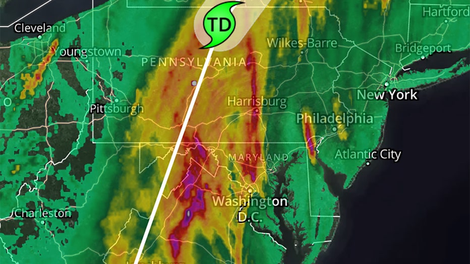
While the storm may be winding down in our region, flooding concerns remain. Washington, D.C. and many of the surrounding counties are under flood warnings that often follow heavy storms that inundate areas with heavy rain in a short amount of time. As much as five inches of rain fell in some parts of the region Friday.
Many costal areas adjacent to the Chesapeake remain under a tornado watch until later this afternoon.
Flooding concerns, tornado threats as storm moves out
1030AM UPDATE
Flooding concerns and the threat of tornadoes continue Friday across the D.C. region as the remnants of Debby churn northward.

The Bay Bridge is under full wind restrictions. The Hatem and Nice/Middleton Bridges are under wind warnings.
Here's what that means:
Wind Warnings (sustained wind speeds of 30-39 mph for a continuous period of 10 mins or more; or wind gusts persistently exceed 30 mph over a period of 15 mins) operators of house trailers, box trailers, motorcycles, vehicles with roof-mount racks containing cargo or any other vehicle that may be subject to high winds are advised to use caution while traveling across the bridge.
Full Wind Restrictions (sustained wind speeds exceeding 50 mph for a continuous period of 10 mins or more; or wind gusts persistently exceed 50 mph over a period of 15 mins) only automobiles, pickup trucks, flatbed trailers, commercial buses and heavy-laden tractor/trailers are permitted to cross the bridge. Tractor-box trailer combinations will not be permitted to cross any bridge if the gross weight is less than 64,000 pounds.
9AM UPDATE
A tornado warning that was issued for Washington, D.C. on Friday morning has cleared as the remnants of Tropical Storm Debby pushed through, unleashing soaking rains, flash flooding and gusty winds across the area.

Debby’s remnants flood roadways, strand vehicles in Maryland
The remnants of Tropical Storm Debby flooded roadways and stranded vehicles Friday in parts of Maryland as it hammered the region with heavy rains, flash flooding and the threat of tornadoes.
Here's the latest power outage numbers:
Pepco 2,419
BGE 12,340
Dominion Energy 1,070
SMECO 200
830AM UPDATE

Debby’s remnants hit DMV LIVE updates: Tornado Warning issued for DC
A Tornado Warning was issued for D.C. Friday as remnants of Debby hit the DMV with soaking rains, flash flooding and gusty winds.
A tornado warning remains in effect until 8:45 AM EDT for the central District of Columbia.
At 8:30 AM EDT, a severe thunderstorm capable of producing a tornado was located over Gallaudet University, moving north at 35 mph.
Hazard: Tornado.
Source: Radar indicated rotation.
Impact: For those in the direct path of a tornado touchdown, flying debris will be dangerous to those caught without shelter. Damage to roofs, siding, and windows may occur. Mobile homes may be damaged or destroyed. Tree damage is likely.
This tornadic thunderstorm will remain over mainly rural areas of the central District of Columbia, including the following locations: National Arboretum.
Precautionary/Preparedness Actions:
Take cover now! Move to a basement or an interior room on the lowest floor of a sturdy building. Avoid windows. If you are outdoors, in a mobile home, or in a vehicle, move to the closest substantial shelter and protect yourself from flying debris.
820AM UPDATE
Multiple Tornado Warnings have been issued across the DMV.
A tornado warning remains in effect until 8:30 AM EDT for north central Carroll County…
At 8:13 AM EDT, a severe thunderstorm capable of producing a tornado was located near Westminster, moving north at 35 mph.
Hazard… Tornado.
Source… Radar indicated rotation.
Impact… For those in the direct path of a tornado touchdown, flying debris will be dangerous to those caught without shelter. Damage to roofs, siding, and windows may occur. Mobile homes may be damaged or destroyed. Tree damage is likely.
This tornadic thunderstorm will remain over mainly rural areas of north central Carroll County, including the following locations… Wagners Mill, New Windsor, and Uniontown.
Precautionary/preparedness actions…
Take cover now! Move to a basement or an interior room on the lowest floor of a sturdy building. Avoid windows. If you are outdoors, in a mobile home, or in a vehicle, move to the closest substantial shelter and protect yourself from flying debris.

Annapolis underwater as Debby’s remnants flood streets
Large portions of downtown Annapolis were underwater Friday as the remnants of Debby flooded streets on its way up the coast.
8AM UPDATE
A Tornado Warning remains in effect until 815 am edt for southwestern Prince George’s, northwestern Charles, and southeastern Fairfax Counties.
At 807 AM EDT, a severe thunderstorm capable of producing a tornado
was located over Huntington, moving north at 40 mph.
HAZARD...Tornado.
SOURCE...Radar indicated rotation.
IMPACT...For those in the direct path of a tornado touchdown, flying
debris will be dangerous to those caught without shelter.
Damage to roofs, siding, and windows may occur. Mobile
homes may be damaged or destroyed. Tree damage is likely.
This tornadic thunderstorm will remain over mainly rural areas of
southwestern Prince Georges, northwestern Charles and southeastern
Fairfax Counties, including the following locations... Mount Vernon,
Bryans Road, and Accokeek.
PRECAUTIONARY/PREPAREDNESS ACTIONS...
TAKE COVER NOW! Move to a basement or an interior room on the lowest
floor of a sturdy building. Avoid windows. If you are outdoors, in a
mobile home, or in a vehicle, move to the closest substantial shelter
and protect yourself from flying debris.
The National Weather Service in Sterling Virginia has issued a
* Tornado Warning for North central Carroll County in north central Maryland...
* Until 830 AM EDT.
* At 804 AM EDT, a severe thunderstorm capable of producing a tornado
was located near Westminster, moving north at 40 mph.
HAZARD...Tornado.
SOURCE...Radar indicated rotation.
IMPACT...For those in the direct path of a tornado touchdown,
flying debris will be dangerous to those caught without
shelter. Damage to roofs, siding, and windows may occur.
Mobile homes may be damaged or destroyed. Tree damage is
likely.
* This dangerous storm will be near...
Westminster around 810 AM EDT.
Other locations impacted by this tornadic thunderstorm include
Wagners Mill, New Windsor, Marston, and Uniontown.
PRECAUTIONARY/PREPAREDNESS ACTIONS...
TAKE COVER NOW! Move to a basement or an interior room on the lowest
floor of a sturdy building. Avoid windows. If you are outdoors, in a
mobile home, or in a vehicle, move to the closest substantial shelter
and protect yourself from flying debris.
745AM UPDATE
TORNADO WARNINGS for Montgomery, Howard, Carroll Counties. TORNADO WATCHES are in effect for the entire DMV. FLASH FLOOD WARNINGS are in place for parts of the region on Friday as the remnants of Debby bring heavy rains, flash flooding and damaging winds.
7AM UPDATE
Tornado Watches for:
District of Columbia
Maryland Counties Included:
-Anne Arundel
-Baltimore
-Calvert
-Caroline
-Carroll
-Cecil
-Charles
-Dorchester
-Frederick
-Harford
-Howard
-Kent
-Montgomery
-Prince George’s
-Queen Anne’s
-Somerset
-St. Mary’s
-Talbot
-Wicomico
-Worcester
Maryland Independent Cities Included:
-Baltimore City
Virginia Counties Included:
-Accomack
-Arlington
-Caroline
-Essex
-Fairfax
-Fauquier
-King and Queen
-King George
-King William
-Lancaster
-Loudoun
-Middlesex
-Northumberland
-Prince William
-Richmond
-Spotsylvania
-Stafford
-Westmoreland
Virginia Independent Cities Included:
- Alexandria
- Fairfax
- Falls Church
- Fredericksburg
- Manassas
- Manassas Park
Adjacent coastal waters included are
- Delaware Bay waters north of East Point NJ to Slaughter Beach DE
- Delaware Bay waters south of East Point NJ to Slaughter Beach DE
- Chesapeake Bay north of Pooles Island MD
- Chesapeake Bay from Pooles Island to Sandy Point MD
- Chesapeake Bay from Sandy Point to North Beach MD
- Chesapeake Bay from North Beach to Drum Point MD
- Chesapeake Bay from Drum Point MD to Smith Point VA
- Tidal Potomac from Key Bridge to Indian Head MD
- Tidal Potomac from Indian Head to Cobb Island MD
- Tidal Potomac from Cobb Island MD to Smith Point VA
- Patapsco River including Baltimore Harbor
- Chester River to Queenstown MD
- Eastern Bay
- Choptank River to Cambridge MD and the Little Choptank River
- Patuxent River to Broomes Island MD
- Tangier Sound and the inland waters surrounding Bloodsworth Island
- Chesapeake Bay from Smith Point to Windmill Point VA
- Rappahannock River from Urbanna to Windmill Point
Delaware counties included are
- Kent
- New Castle
Pennsylvania counties included are
- Adams
- Berks
- Bradford
- Bucks
- Carbon
- Chester
- Columbia
- Cumberland
- Dauphin
- Delaware
- Juniata
- Lackawanna
- Lancaster
- Lebanon
- Lehigh
- Luzerne
- Lycoming
- Monroe
- Montgomery
- Montour
- Northampton
- Northumberland
- Perry
- Philadelphia
- Pike
- Schuylkill
- Snyder
- Sullivan
- Susquehanna
- Union
- Wayne
- Wyoming
- York
645AM UPDATE
Tornado Warnings for all parts of DMV have expired. Flash Flood Warnings have been issued for parts of D.C., Maryland, and Virginia.
The National Weather Service in Sterling Virginia has issued a
* Flash Flood Warning for...
Northwestern District of Columbia...
South Central Montgomery County in central Maryland...
Arlington County in northern Virginia...
Northeastern Fairfax County in northern Virginia...
The Western City of Alexandria in northern Virginia...
The City of Falls Church in northern Virginia...
* Until 945 AM EDT.
* At 637 AM EDT, Doppler radar indicated thunderstorms producing
heavy rain across the warned area. Between 0.5 and 1 inch of rain
has fallen. The expected rainfall rate is 3 to 5 inches in 1 hour.
Additional rainfall amounts of 1 to 2 inches are possible in the
warned area. Flash flooding is ongoing or expected to begin
shortly.
HAZARD...Flash flooding caused by thunderstorms.
SOURCE...Radar.
IMPACT...Flash flooding of small creeks and streams, urban
areas, highways, streets and underpasses as well as
other poor drainage and low-lying areas.
* Some locations that will experience flash flooding include...
Arlington... Alexandria...
Bethesda... Annandale...
Springfield... Vienna...
Groveton... Falls Church...
Mantua... Fort Belvoir...
Pimmit Hills... Mclean...
American Legion Bridge... Rosslyn...
Potomac... Burke...
Oakton... Lincolnia...
Tysons Corner... Franconia...
PRECAUTIONARY/PREPAREDNESS ACTIONS...
Turn around, don`t drown when encountering flooded roads. Most flood
deaths occur in vehicles.
Move to higher ground now. Act quickly to protect your life.
640AM UPDATE
The National Weather Service has issued Tornado Warnings for parts of Maryland and Virginia as the remnants of Debby hit the Washington, D.C., Maryland, and Virginia regions with heavy rains, flash flooding and damaging winds.
A TORNADO WARNING REMAINS IN EFFECT UNTIL 645 AM EDT FOR EAST
CENTRAL FAIRFAX AND THE SOUTHWESTERN CITY OF ALEXANDRIA...
At 639 AM EDT, a severe thunderstorm capable of producing a tornado
was located over I395 and I495 Interchange, or over Springfield,
moving north at 55 mph.
HAZARD...Tornado.
SOURCE...Radar indicated rotation.
IMPACT...For those in the direct path of a tornado touchdown, flying
debris will be dangerous to those caught without shelter.
Damage to roofs, siding, and windows may occur. Mobile
homes may be damaged or destroyed. Tree damage is likely.
This dangerous storm will be near...
Annandale around 645 AM EDT.
Other locations impacted by this tornadic thunderstorm include North
Springfield, Hayfield, and West Springfield.
PRECAUTIONARY/PREPAREDNESS ACTIONS...
TAKE COVER NOW! Move to a basement or an interior room on the lowest
floor of a sturdy building. Avoid windows. If you are outdoors, in a
mobile home, or in a vehicle, move to the closest substantial shelter
and protect yourself from flying debris.
630AM UPDATE
VIRGINIA TORNADO WARNING
The National Weather Service in Sterling Virginia has issued a Tornado Warning for...
Southern Arlington County in northern Virginia...
Southeastern Fairfax County in northern Virginia...
East central Prince William County in northern Virginia...
The southwestern City of Alexandria in northern Virginia...
* Until 645 AM EDT.
* At 622 AM EDT, a severe thunderstorm capable of producing a tornado
was located near Woodbridge, moving north at 55 mph.
HAZARD...Tornado.
SOURCE...Radar indicated rotation.
IMPACT...For those in the direct path of a tornado touchdown,
flying debris will be dangerous to those caught without
shelter. Damage to roofs, siding, and windows may occur.
Mobile homes may be damaged or destroyed. Tree damage is
likely.
* This dangerous storm will be near...
Springfield, Groveton, Fort Belvoir, Woodbridge, Burke, Lorton,
Franconia, Hybla Valley, and Newington around 625 AM EDT.
Alexandria, Annandale, Huntington, Lincolnia, and I395 and I495
Interchange around 630 AM EDT.
Mantua around 635 AM EDT.
Other locations impacted by this tornadic thunderstorm include
Hayfield, North Springfield, Mount Vernon, West Springfield,
Ravensworth, Mason Neck, and Potomac Heights.
PRECAUTIONARY/PREPAREDNESS ACTIONS...
TAKE COVER NOW! Move to a basement or an interior room on the lowest
floor of a sturdy building. Avoid windows. If you are outdoors, in a
mobile home, or in a vehicle, move to the closest substantial shelter
and protect yourself from flying debris.

FOX 5 Weather forecast for Friday, August 9
Taylor Grenda has the FOX 5 Weather forecast for Friday, August 9
MARYLAND TORNADO WARNING
...A TORNADO WARNING REMAINS IN EFFECT UNTIL 630 AM EDT FOR
NORTHWESTERN CHARLES COUNTY...
At 622 AM EDT, a severe thunderstorm capable of producing a tornado
was located near Woodbridge, moving north at 45 mph.
HAZARD...Tornado.
SOURCE...Radar indicated rotation.
IMPACT...For those in the direct path of a tornado touchdown, flying
debris will be dangerous to those caught without shelter.
Damage to roofs, siding, and windows may occur. Mobile
homes may be damaged or destroyed. Tree damage is likely.
Locations impacted include...
Bryans Road, Potomac Heights, Marbury, and Rison.
PRECAUTIONARY/PREPAREDNESS ACTIONS...
TAKE COVER NOW! Move to a basement or an interior room on the lowest
floor of a sturdy building. Avoid windows. If you are outdoors, in a
mobile home, or in a vehicle, move to the closest substantial shelter
and protect yourself from flying debris.
If a tornado or other severe weather is spotted, report it to the
National Weather Service or your local nearest law enforcement agency
who will send your report. This act may save lives of others in the
path of dangerous weather.
6AM UPDATE
A TORNADO WARNING REMAINS IN EFFECT UNTIL 615 AM EDT FOR WEST
CENTRAL CHARLES COUNTY...
At 602 AM EDT, a severe thunderstorm capable of producing a tornado
was located over Fairview Beach, moving north at 40 mph.
HAZARD...Tornado.
SOURCE...Radar indicated rotation.
IMPACT...For those in the direct path of a tornado touchdown, flying
debris will be dangerous to those caught without shelter.
Damage to roofs, siding, and windows may occur. Mobile
homes may be damaged or destroyed. Tree damage is likely.
This tornadic thunderstorm will remain over mainly rural areas of
west central Charles County, including the following locations...
Nanjemoy.
Debby’s remnants hit DC live updates: Tornado Warning remains in effect
PRECAUTIONARY/PREPAREDNESS ACTIONS...
TAKE COVER NOW! Move to a basement or an interior room on the lowest
floor of a sturdy building. Avoid windows. If you are outdoors, in a
mobile home, or in a vehicle, move to the closest substantial shelter
and protect yourself from flying debris.
Tornadoes are extremely difficult to see and confirm at night. Do not
wait to see or hear the tornado. TAKE COVER NOW!