

Hurricane tracker: Could Helene impact DC area? Current track, timing
WASHINGTON - Remnants of Tropical Storm Helene could possibly impact the Washington, D.C. region later this week.
Helene intensified into a named storm Tuesday and could potentially become a major hurricane later this week.
Forecast models currently predict it will reach Category 2 status and make landfall near Florida’s Gulf Coast by Thursday evening.
The storm’s remnants are projected to move towards the Tennessee Valley or the Midwest.
If the storm’s path shifts slightly, its remnants could impact the Washington, D.C. area late Friday into Saturday morning.
"If the track would go a little further west, we wouldn't see too much in the way of impacts here in the Washington area," FOX 5's Tucker Barnes said. "But some of the models to try to bring us some rain here by Friday and Saturday. So we've got some question marks for the end of the week."
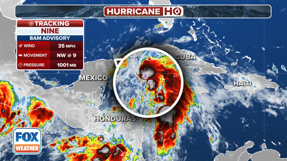
Tropical Storm Helene formed in the northwestern Caribbean Sea on Tuesday, becoming the eighth named storm of the 2024 Atlantic hurricane season.
The National Hurricane Center (NHC) said the system, formerly known as Potential Tropical Cyclone Nine, developed into a tropical storm in the Caribbean Sea approaching the Gulf of Mexico as showers and thunderstorms became sufficiently organized around the area of low pressure.
Preparations are underway along Florida's Panhandle and Gulf Coast states for dangerous storm surge, heavy rain and flash flooding from Helene as the storm is expected to strengthen in the coming days. Under the current track, Helene could make landfall as a hurricane Thursday along Florida's Big Bend region.
Where is Tropical Storm Helene?
The NHC found that maximum sustained winds reached at least 40 mph, allowing for the formation of Tropical Storm Helene on Tuesday morning.
Tropical Storm Helene information and location.
The system is moving northwest, and that general motion is expected into Tuesday night, followed by a faster northward to north-northeastward motion on Wednesday and Thursday.
Where are watches and warnings in effect?
A Tropical Storm Warning is in effect for the Lower Florida Keys west of the Seven Mile Bridge and for the Dry Tortugas.
A Tropical Storm Watch is in effect for the Middle Florida Keys from the Seven mile Bridge to the Channel 5 Bridge.
A Hurricane Watch is in effect from Englewood to Indian Pass and Tampa Bay.
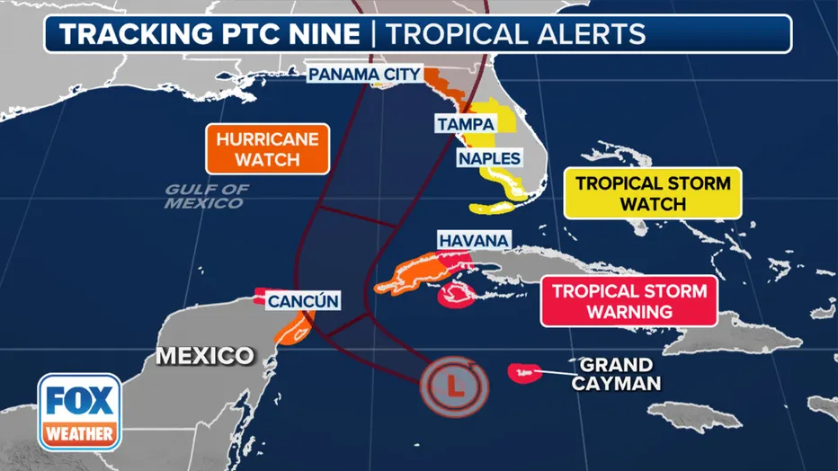
Watches and warnings from Helene.
With the current forecast, hurricane conditions are possible within the watch areas by early Wednesday, and tropical storm conditions are expected in the warning areas beginning Tuesday.
The NHC said residents of the northeastern Gulf Coast, the Florida Panhandle and parts of Florida's west coast should continue to monitor the forecast for updates.
Projected path: Where is Tropical Storm Helene going?
Tropical Storm Helene is likely to bring gusty winds, heavy rain with the potential for flash flooding, coastal flooding and dangerous beach conditions to Mexico's Yucatan Peninsula, western Cuba and the U.S. Gulf Coast from Louisiana to Florida.
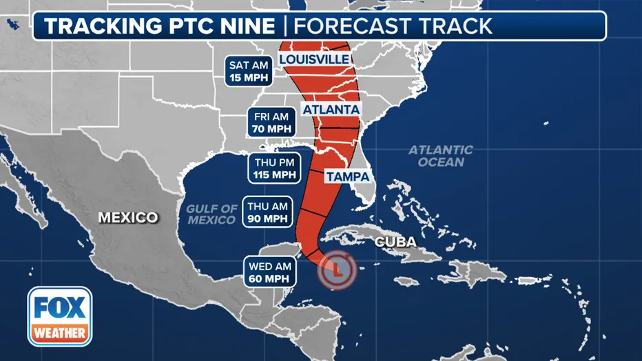
Tropical Storm Helene forecast cone. (FOX Weather)
According to the NHC, models suggest a more well-defined center should develop through Monday and Tuesday, and conditions appear favorable for significant strengthening as the system moves across the Gulf of Mexico, potentially making landfall in Florida on Thursday.
Spaghetti models
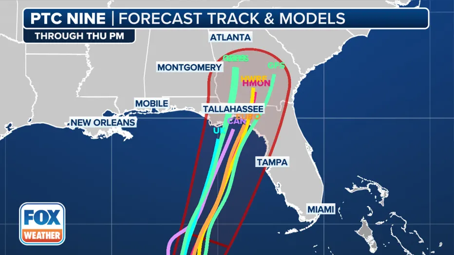
Tropical Storm Helene spaghetti models. (FOX Weather)
Heavy rainfall will spread from the Gulf Coast into the Southeast U.S. beginning on Wednesday and continuing through Friday, potentially causing flash and river flooding.
What's next to watch?
One area under watch is a tropical disturbance near the west coast of Africa, according to the NHC.
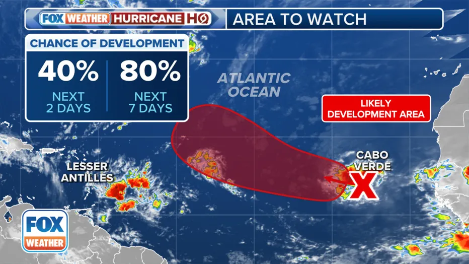
A look at the latest odds of development a tropical disturbance in the Atlantic. (FOX Weather)
"Environmental conditions appear favorable for gradual development of this system, and a tropical depression is likely to form in a few days while it moves westward to west-northwestward across the eastern and central tropical Atlantic," the agency noted in its latest outlook Tuesday.
Right now, the NHC is giving the system a high chance of development.
NOAA Hurricane Center
For more information, click HERE.
Steven Yablonski and Aaron Barker, with the Associated Press, helped contribute to this report.